Ticker for May 31, 2012
MESONET TICKER ... MESONET TICKER ... MESONET TICKER ... MESONET TICKER ...
May 31, 2012 May 31, 2012 May 31, 2012 May 31, 2012
Drought Update
Catchy title, eh??
The latest U.S. Drought Monitor map shows the drought situation before any
of the rains that fell Tuesday night through Thursday morning (remember, there
is a 7 a.m. Tuesday cutoff point for consideration of moisture). Some of this
will obviously be adjusted for next week's map, but other areas will
undoubtedly see further deterioration minus additional rains.
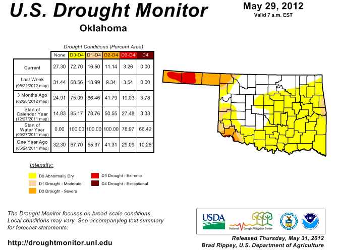
You will notice a larger area of "abnormally dry" conditions (D0 - the
precursor to drought development). Some of that will be relived by the rains
of the last couple of days. Other parts of the state saw an intensification.
One area of great concern, and you'll see why a bit later, is that new area
of moderate drought in far eastern Oklahoma. Those dry conditions continue to
creep over from Arkansas and points farther east.
And if there is one thing you do NOT want, it's something creeping over from
Arkansas. Can I get an amen?
Harper County went from D0-D1 to mostly D2 based on my first-hand account of
the conditions out there. Those of you that have followed the story of the
struggles my favorite little pond in the world south of Buffalo has endured
over the last couple of years will be glad to know it has officially reached
mudhole status once again. It ain't much, but it's a step up from dry. However,
it is obviously shrinking to oblivion once again and remains a far cry from
where it was in its heyday.
May 27, 2012: 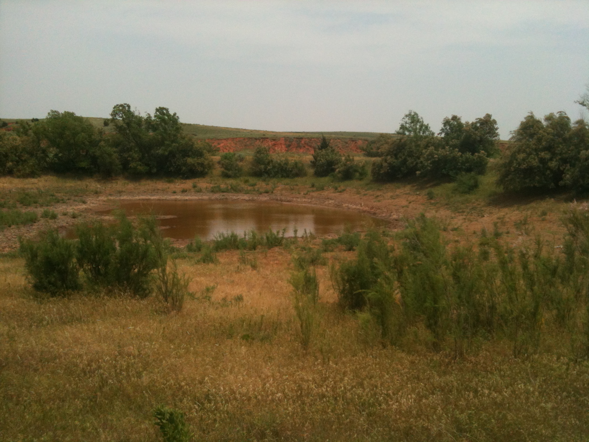
May 2009: 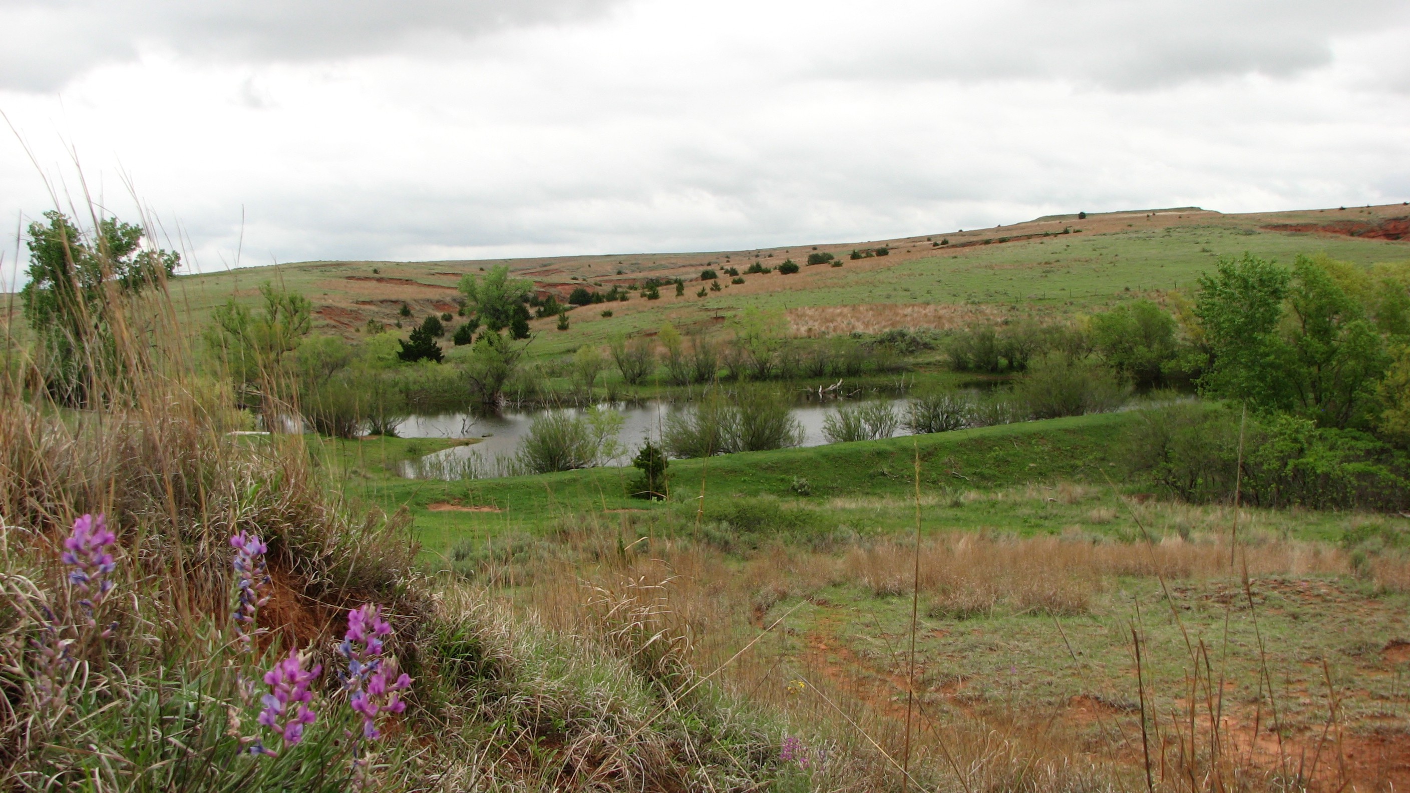
The recent rains were still found to be somewhat lacking in some areas that
desperately needed it, and maybe a bit too much too fast in other areas.
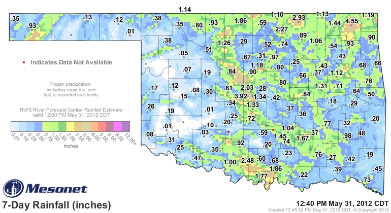
Ask Arnett or Slapout, who both managed to finish with about a swallow of water
for the month. Of the 120 Oklahoma Mesonet stations, 24 finished the month
(unless we get a spot of rain later today) with less than an inch of rainfall.
And much of the state continued with less than adequate moisture as we head into
the hottest (and time of most water stress from evaporation, transpiration and
human consumption) part of the year. The Ninnekah recorded 6.17 inches during
May to lead all Mesonet stations.
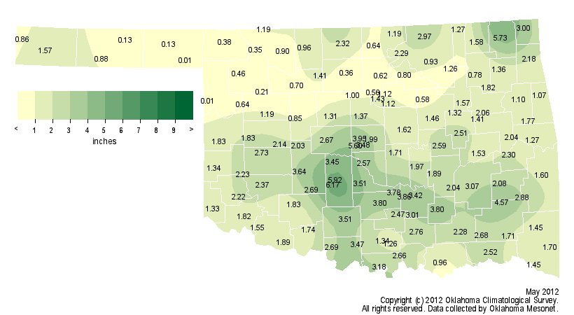
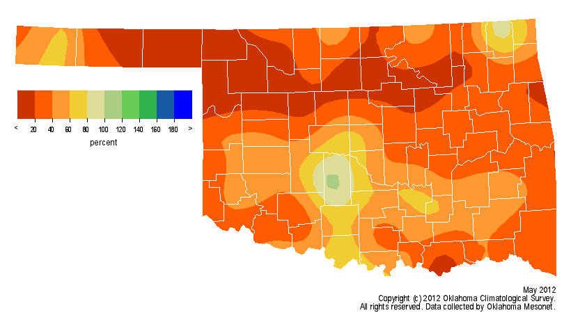
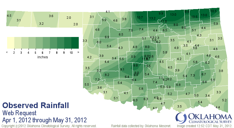
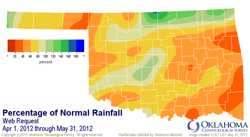
Combined with April, things didn't improve all that much in some areas. Eastern,
southern and northwestern Oklahoma are still being popped by the heat and lack of
moisture. One benefit of the April deluges in north central Oklahoma is they are
counteracting some of the damage from a dry May. The continued dry areas are
both obvious and troubling, however.
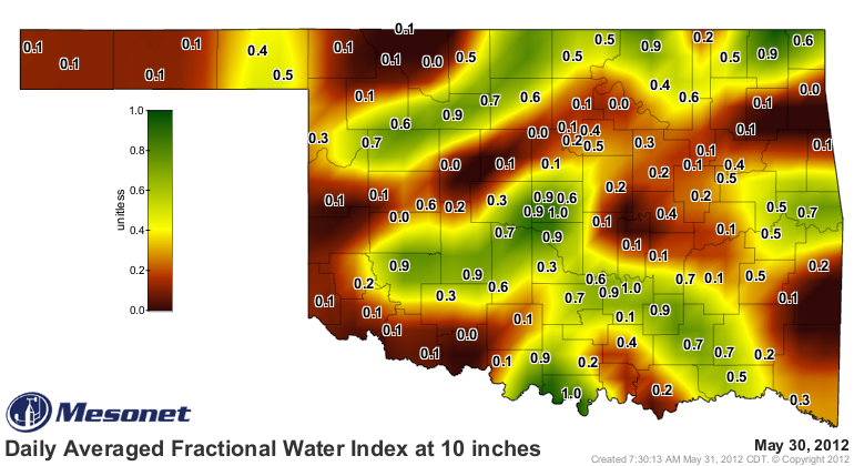
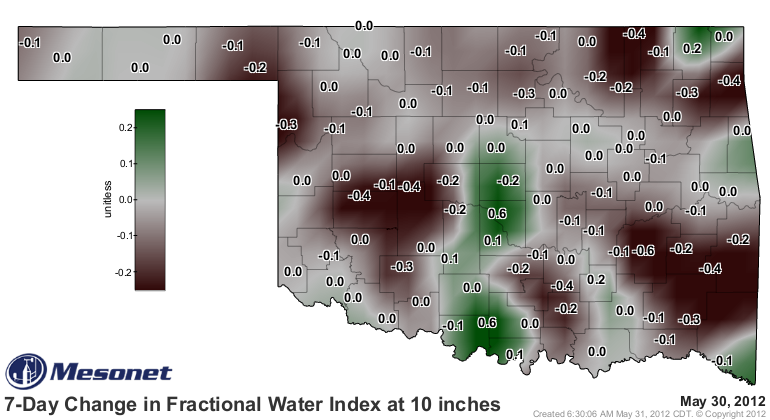
The areas that have received rain and those that haven't, or at least haven't
kept up with demand from the sun and plants, show up quite well on the
Mesonet soil moisture map as well. These maps are from data at the 10-inch
depth. Some areas on the 7-day change map don't show up because they simply
have no room to drop any further.
There is still plenty of time to recover before summer arrives. Now "plenty"
might be subject to interpretation, but until I see the whites of July's eyes,
I'm holding out hope.
Gary McManus
Associate State Climatologist
Oklahoma Climatological Survey
(405) 325-2253
gmcmanus@mesonet.org
May 31 in Mesonet History
| Record | Value | Station | Year |
|---|---|---|---|
| Maximum Temperature | 107°F | WAUR | 1998 |
| Minimum Temperature | 36°F | BOIS | 2004 |
| Maximum Rainfall | 5.41″ | OKCN | 2013 |
Mesonet records begin in 1994.
Search by Date
If you're a bit off, don't worry, because just like horseshoes, “almost” counts on the Ticker website!