Ticker for May 15, 2012
MESONET TICKER ... MESONET TICKER ... MESONET TICKER ... MESONET TICKER ...
May 15, 2012 May 15, 2012 May 15, 2012 May 15, 2012
Whither rain??
Mother Nature is determined to make me look stupid, and I definitely don't need
any help in that department. I've been bragging continuously how the spring rains
will help keep our summer from going to the extreme side. Well, that was a good
idea in principle, except there was no guarantee the rain would continue. Now
that we are smack dab in the middle of Oklahoma's normal (HAHA!) rainy season,
the spigots have suddenly turned off. And if we're not careful, we're going to
end up with this May as one of our driest on record just in time for summer. Take
a look at our rainfall so far this month.
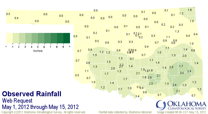
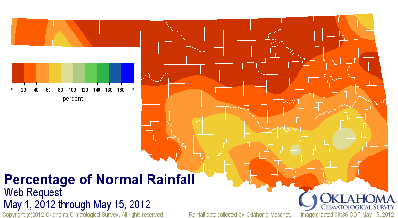
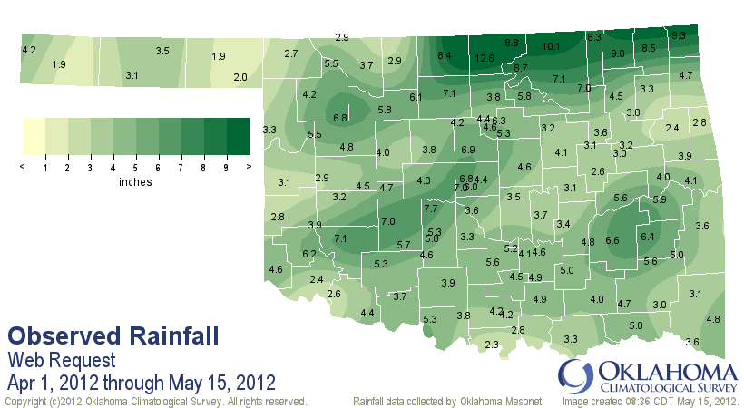
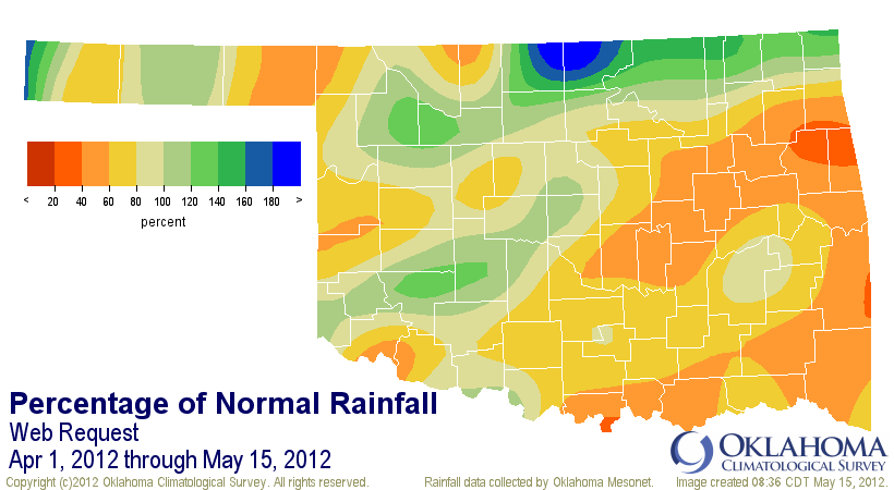
Now all those zeroes in the first map across northern Oklahoma aren't all that
unwelcome after the dosing of torrential rains they received in April. Remember,
some of those towns (e.g., Blackwell, Ponca City) broke their all-time April
rainfall records. For other parts of the state, however, the dry weather has
continued on from April.
And remember (once again) that this dearth of moisture has come with unusual
heat. Our March was easily the warmest on record, April the 10th warmest, and
our year-to-date (January-April) and spring-to-date (March-April) periods
have both shattered the record books. Upper-90s and 100s were common throughout
the western half of the state in late April and the first week of May. That
tends to speed up the impacts of going without rainfall, and can hasten those
areas quickly back into drought.
Where will May temperatures end up? It's going to end in the top half of the
warmest for sure and will be moving up the rankings over the next week with
more heat. It's currently about 4 degrees above normal for the first half of
the month.
-****-
Max T Min T Avg T
May 1-15 Avg (2012) 80.6F 58.5F 69.6F
May 1-15 Normal 77.5F 53.5F 65.6F
Departure 3.1F 5.0F 4.0F
-***-
I can say this with very little uncertainty, however ... both the January-May
and March-May (spring) statewide average temperatures will shatter
the previous record marks (both held by similar periods in 2006). If we keep
May's statewide average for 2012 where it was today (69.6F), the records would
look like this:
January-May 2012 55.7F
January-May 2006 55.1F
March-May 2012 64.2F
March-May 2006 62.9F
The May temperature will obviously finish higher than that, so the writing's
on the wall for May temperatures. May precipitation is more uncertain. The
driest May on record dates back to 1988 with a statewide average of 1.3 inches.
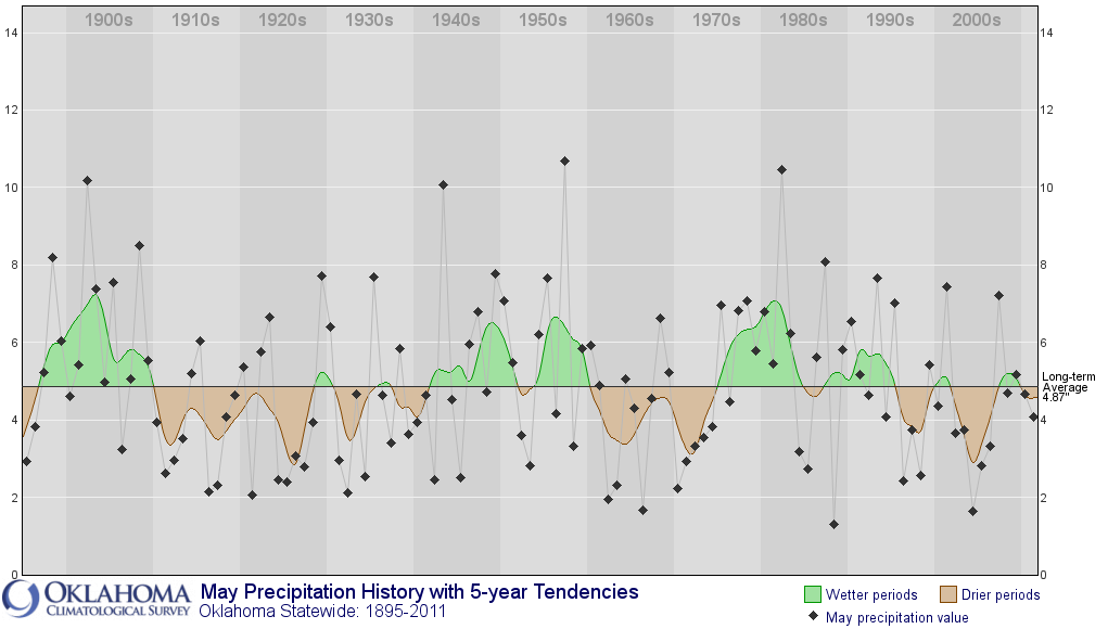
The statewide average for May thus far stands at 0.87 inches with very little
rainfall in sight until the weekend. And then we have another week to go to add
to our rainfall totals, so odds don't favor us breaking that record, but we
could definitely end up on the low side for the month. For kicks (come on, join
me in climatological excitement!), notice how our May rainfall totals have been
favoring the dry side over the last 20 years of so? Interesting!
As mentioned throughout the last 365 days or so, burgeoning dry conditions are
not the ideal state to have heading into summer. We're very quickly approaching
the time of year when things like precipitation and soil moisture (or lack
thereof on both accounts) have a significant impact on what type of summer heat
we experience. No need to rehash last year's debacle by Mother Nature, but
any slowdown in the rains can mean more heat. As shown in a Ticker gone by,
temperatures for the summer months of June-August show a strong negative
correlation with precipitation (i.e., it's hotter when it doesn't rain, it's
milder when it does). This graph illustrates that. Each column is a month
(January to the far left) and each bar is a section of the state. Bars below
are a negative correlation, bars above are positive correlations. The
correlations are clearly more significant during the summer months.
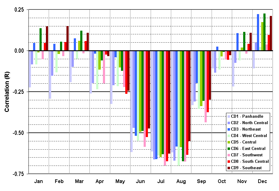
The correlations are not too strong for May, which is probably why we've had
nice weather over the last week or so instead of baking. But during that June-
August period, the power of the sun takes over and dry weather can quickly
spell HEAT!
Mother Nature has yet to write that story, however. Let's not panic until we
see the whites of her eyes (or the reds on the map).
Gary McManus
Associate State Climatologist
Oklahoma Climatological Survey
(405) 325-2253
gmcmanus@mesonet.org
May 15 in Mesonet History
| Record | Value | Station | Year |
|---|---|---|---|
| Maximum Temperature | 104°F | GRA2 | 2022 |
| Minimum Temperature | 32°F | BOIS | 2011 |
| Maximum Rainfall | 5.38″ | KETC | 2020 |
Mesonet records begin in 1994.
Search by Date
If you're a bit off, don't worry, because just like horseshoes, “almost” counts on the Ticker website!