Ticker for May 10, 2012
MESONET TICKER ... MESONET TICKER ... MESONET TICKER ... MESONET TICKER ...
May 10, 2012 May 10, 2012 May 10, 2012 May 10, 2012
Drought returning to parts of Oklahoma?, and the latest tornado numbers
There's a reason drought is known as the "creeping hazard." It will often
manifest itself and gain a toe-hold before you realize it. You take your eye off
of drier areas, drawn by other weather matters such as tornadoes and torrential
rainfall, and the next time you look ... things have gone downhill without you
even knowing there is a hill! Now there isn't much to worry about just yet, but
the southern/southeastern half of the state has started to dry out a bit. That
is evident in data from the Oklahoma Mesonet. Take a look at the rainfall map
from April 1-May 10 and you can get a sense of where the rains fell (by the
lake-full in some cases), and where they stayed away.
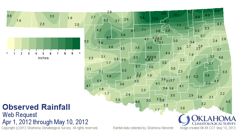
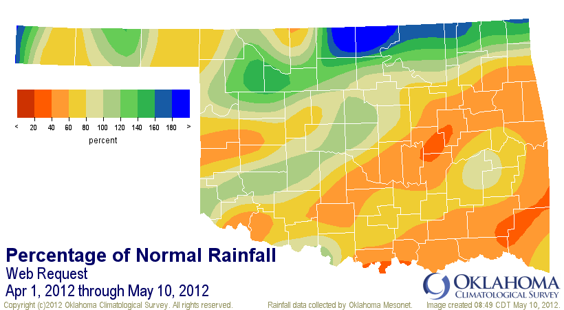
So if you were sitting in the northern third of Oklahoma or along parts of the
I-44 corridor, you received your fair share. Other parts of the state, not so
much. Another telling indicator is the soil moisture reaction to the rainfall
deficits.
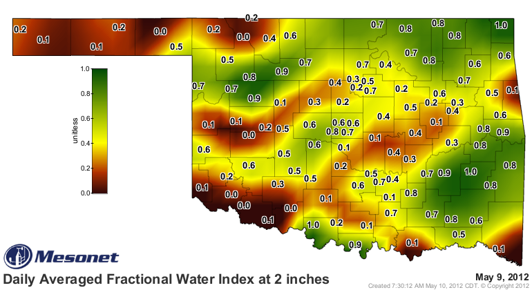
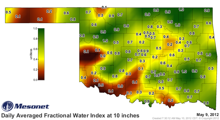
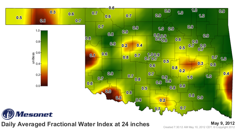
A pretty clear indication that the topsoils are beginning to dry a bit and that
is slowly starting to help dry out those lower levels as well. This is not a
shock, of course. The missed precipitation in parts of the state to go along
with the unusual warmth has placed a lot of pressure on the soil moisture once
again. The heat has been a double-edged sword. Not only does it increase
evaporation, but it has spurred growth of the state's vegetation, which also
draws moisture from the soils. Here's an even better indicator ... the change
in soil moisture at 10 inches over the last seven days.
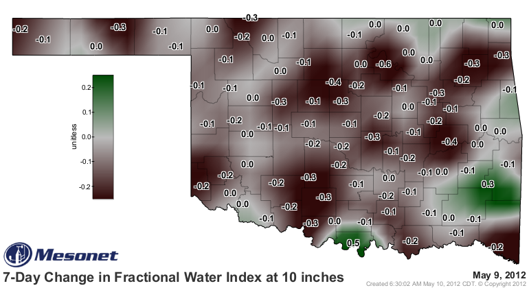
As Scooby Doo would say: "RUH ROH!" Now this isn't reason to panic just yet.
The essence of convective precipitation is hit-and-miss. Some parts of the
state have just been unlucky so far. And to be truthful, those areas that
received too much rain (hey to Blackwell and Ponca City) have also been unlucky.
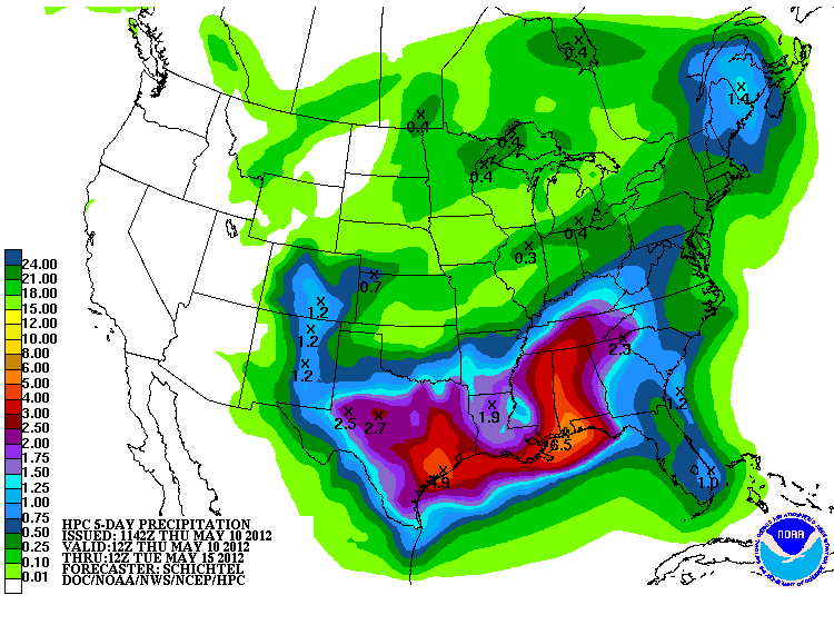
Some relief might be on its way as we speak (write?). The latest rainfall total
prediction from the NWS' Hydrometeorological Prediction Center indicates a
chance for 0.5-1.5 inches of moisture across far southern Oklahoma over the
next few days.
The U.S. Drought Monitor report from this morning continues to show about the
same drought picture in Oklahoma that we've had for the last few weeks.
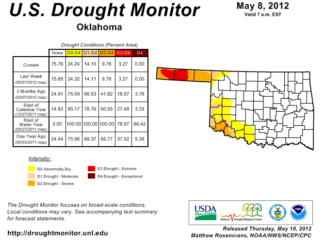
Again, nothing to panic about. Still lots of time for the spring rains to
return to those parts of the state. Plus, the drier weather will benefit the
wheat harvest and also keep some of those moisture-related wheat diseases at
bay. We will continue to keep track of any sort of increasing dry conditions.
Drought is perhaps the most boring of all weather phenomena ... that's why
climatologists are so well-suited for the job.
------------------------------------------------------------------------------
The latest number of confirmed tornadoes in the state thus far in 2012 is
up to 50 according to Tornado Tally-Upper Doug Speheger from the Norman NWS
office. That includes five twisters in March, 43 in April and two from May.
That is shockingly close to the record-setting April number of 50 from last
year, and now marks this April as the second-most active since accurate records
began in 1950. That's a total of 93 April tornadoes over the last two years.
At this time last year, Oklahoma had a total of 51 tornadoes. Being close to
last year's pace is certainly a bit alarming, especially since 2011 ended up
with a second-highest annual total of 119.
What does this portend for the rest of May and 2012? Not a thing. Speculating
on tornado number using extrapolation is a fool's game, and I might be boring,
but I ain't no fool!
Gary McManus
Associate State Climatologist
Oklahoma Climatological Survey
(405) 325-2253
gmcmanus@mesonet.org
May 10 in Mesonet History
| Record | Value | Station | Year |
|---|---|---|---|
| Maximum Temperature | 102°F | ERIC | 2022 |
| Minimum Temperature | 31°F | EVAX | 2019 |
| Maximum Rainfall | 5.62″ | IDAB | 2009 |
Mesonet records begin in 1994.
Search by Date
If you're a bit off, don't worry, because just like horseshoes, “almost” counts on the Ticker website!