Ticker for May 4, 2012
MESONET TICKER ... MESONET TICKER ... MESONET TICKER ... MESONET TICKER ...
May 4, 2012        May 4, 2012        May 4, 2012        May 4, 2012


When's winter again?

Oklahoman reporter Bryan Painter sends along word from southwestern Oklahoma
that wheat harvest has started already, possibly as early as it ever has, at
least in the memory of some local wheat folks:

"The Oklahoma wheat harvest is underway with at least one report of
wheat being cut on Thursday. 'We received our first load of new crop
wheat this morning,' said Mike Cassidy of Cassidy Grain in Frederick
Friday. 'Brittan Newhouse cut the wheat yesterday, May 3rd, 2012.
Grain came from 6 miles west of Frederick, off of the Gottschall Farm.
This is earliest harvest date that I am aware of.' Typically harvest
around Frederick starts a week or so before or just after Memorial
Day. But a warm winter and spring have pushed the start date up this
year."

I decided to take a look back at our temperatures over the last 16 months or
so. To this cold-blooded climatologist, this year has been an absolute pleasure
thus far (check back in August) The way I remember things working, we went from
bone-cracking cold in January to mid-February 2011, to really warm (relatively)
weather after mid-February. And then except for a month-long hiatus in
September, it pretty much stayed that way since.

How good is my memory?

What were we talking about again? Oh yeah, temperatures!

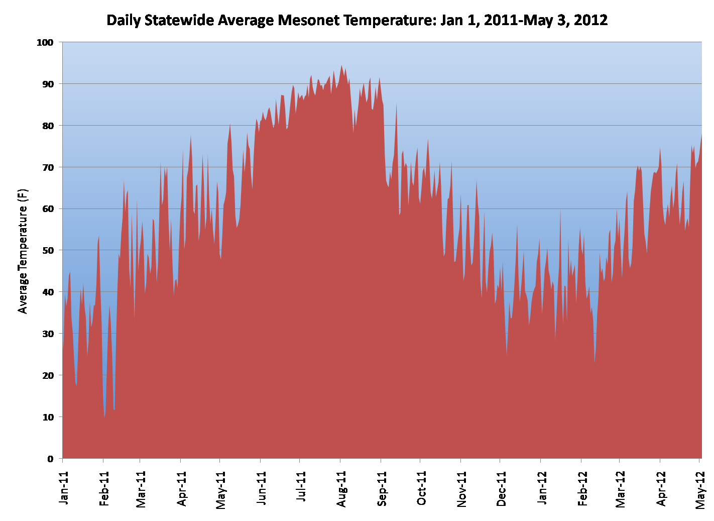
So starting with January 1, 2011, I calculated a statewide average temperature
for every day through yesterday, May 3, 2012, from the Oklahoma Mesonet.
Plotting it up, it turns out some of my recollections are actually true.


From this graph, the bone-cracking cold of Jan-Feb 2011 definitely shows up.
Notice the end of January and the first few days of February...COLD, BLIZZARDY!,
then a warm-up that came with a westerly Chinook-type wind that helped melt a
lot of snow, then the second cold/wintry blast of Feb. 9 and 10 (-31 degrees at
Nowata, coldest temperature ever recorded in Oklahoma).

Then the abrupt transition (100-degree temperature swing) to a warm second half
of February. A steady warm up through spring with a bit of a cool down from
time to time (late-March, late-May). Then straight into the summer from hell.
A tad bit of a cool down in August that ended all of our consecutive day
streaks of triple-digit temperatures, then the bottom dropped out of the heat
right at the beginning of September.

A slow descent into a VERY mild winter, obviously nothing like last year (only
two remotely cold periods showing up in late November and mid-February) then
an abrupt rise back into a very warm spring. You'll notice one difference
between the March and April periods of this year vs. last year -- the peaks that
designate the warm stretches this year last much longer. They're more like
plateaus whereas they resembled points last year. Also, very few dips down into
colder territory.

Obviously the biggest plateau was June-August, 2011, the hottest summer for
any state since records began in 1895. Will this summer be a plateau, or a
collection of points?

Check back in August.

Gary McManus
Associate State Climatologist
Oklahoma Climatological Survey
(405) 325-2253
gmcmanus@mesonet.org
May 4 in Mesonet History
| Record | Value | Station | Year |
|---|---|---|---|
| Maximum Temperature | 106°F | ALTU | 2020 |
| Minimum Temperature | 26°F | KENT | 2013 |
| Maximum Rainfall | 5.55″ | VINI | 1999 |
Mesonet records begin in 1994.
Search by Date
If you're a bit off, don't worry, because just like horseshoes, “almost” counts on the Ticker website!