Ticker for May 2, 2012
MESONET TICKER ... MESONET TICKER ... MESONET TICKER ... MESONET TICKER ...
May 2, 2012        May 2, 2012        May 2, 2012        May 2, 2012


Potpourri ... or alternatively, Mother Nature continues to act the fool

So many tidbits, so little time. Just doesn't seem like we can get an extended
period of boring weather in Oklahoma, and as a climatologist, I do boring for a
living! Regardless, here are some of the strange and fascinating (remember, I
deal in boring for a living) factoids I've come across in the last few days.

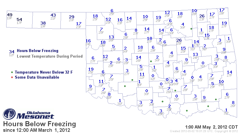
Late Freeze Worries
-------------------
Remember how we were all worried that a late freeze was going to arrive sometime
in March or April and destroy the wheat crop, or the grape crop, or our urban
ornamentals? Didn't happen. Not only did it not happen, it REALLY didn't happen.


Talk about going out with a whimper. I haven't seen such unrealized fears since
some obscure Associate State Climatologist warned about continued drought in
September 2011. Let's see, how do I delete on this thing...

Tornadoes Upping the Ante Again
-------------------------------
Super-Duper Tornado Guru Doug Speheger has counted at LEAST 30 confirmed tornadoes
so far for April. That places April 2012 as the third most active April on record
since accurate statistics began in 1950, behind 2011's 50 and 1957's 40. Added
to the five confirmed twisters in March and the annual count is now up to 35.
Lots of May left to up the ante, but that's also lots of time left to bust (we
hope). Annual average for Oklahoma is 55.

April's Lowest Measured Temperature of 30 Degrees
-------------------------------------------------
Okay, I told you yesterday that only two Mesonet sites reached 32 degrees or
lower (and they stayed at 32 degrees, and for less than an hour each). Plus
the NWS COOP observer at Goodwell measured a 30 degrees. There was also a 32
degree reading from the Beaver COOP observer. Looking back at all the Aprils
for all the stations since 1893, the only year I can find that had such a
dearth of below-freezing readings is 1906 when the lowest recorded reading
ended up as 31 degrees (Fort Sill). There were only 50 reporting stations then,
so they weren't sampling the atmosphere quite as well as we do now. And there
is a lag of about three months for all the COOP station data to get fully
reported, so a colder mark could sneak in there later. Still pretty incredible.

Above Normal Temperatures Are Old Hat
-------------------------------------
With April now in the books, that brings the streak of above-normal statewide-
averaged temperatures up to seven (last September was 1.4 degrees below normal).
That's also 10 out of the last 11, 12 out of the last 14, and 19 out of the
last 25 that have finished above normal starting in April 2010. July 2010 and May
2011 finished right at normal. Seven of the last 13 months have finished
significantly above normal (3 degrees or higher) with March being the winner
at 9.2 degrees above normal.

Blackwell Thumbs Nose at 2011
-----------------------------
A reader alerted me to this. Blackwell saw 10.9 inches of rain in the recent
3-day deluge that left widespread flooding in north central Oklahoma. That's
nearly 5 inches more than Hooker saw in all of 2011 (6.2 inches). In fact, it's
more than all of these Mesonet stations.

Hooker         6.2 inches
Godowell       8.7 inches
Boise City     9.0 inches
Arnett         9.5 inches
Altus         10.3 inches
Kenton        10.5 inches
Erick         10.5 inches
Hollis        10.8 inches

Okay, I've regurgitated enough tidbits for now. I now return you to your
regularly scheduled June weather. Whoops! I meant May.

Gary McManus
Associate State Climatologist
Oklahoma Climatological Survey
(405) 325-2253
gmcmanus@mesonet.org
May 2 in Mesonet History
| Record | Value | Station | Year |
|---|---|---|---|
| Maximum Temperature | 105°F | ALTU | 2020 |
| Minimum Temperature | 24°F | BOIS | 2013 |
| Maximum Rainfall | 4.04″ | HASK | 2022 |
Mesonet records begin in 1994.
Search by Date
If you're a bit off, don't worry, because just like horseshoes, “almost” counts on the Ticker website!