Ticker for April 20, 2012
MESONET TICKER ... MESONET TICKER ... MESONET TICKER ... MESONET TICKER ...
April 20, 2012     April 20, 2012     April 20, 2012     April 20, 2012


La Nina nearly gone, El Nino chances slip a bit

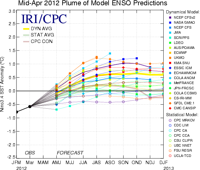
The latest ENSO (El Nino/Southern Oscillation) model prediction plume continues
to show a rapid transition to ENSO-neutral conditions in the equatorial south
pacific from our double-dip helping of La Nina. Nothing shocking there...La Nina
(and El Nino) does tend to fade during the summer months anyway, as we saw last
summer. Check out the plume for yourself. Remember, an anomaly of -0.5C or less
indicates a La Nina event and greater than +0.5C would signify an El Nino.


The dynamical models have recently gained some ground on the statistical models
and have proven to have more skill, and specifically, research has shown that
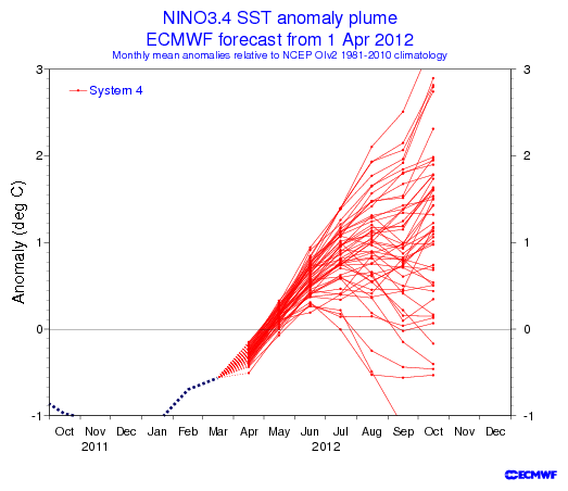
the ECMWF SSTA model has performed the best. That is especially worth noting
since it is predicting a +1.0C anomaly for the July-September 3-month period,
which would represent El Nino conditions. Here's a spread of the ECMWF forecasts.


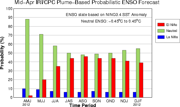
Now based on ALL of the model output (statistical and dynamical), the forecasts
still slightly favor ENSO-Neutral over El Nino as we get into the cool season.
The forecasts show little chance for a triple-dip La Nina event.


The dynamical forecasts altogether point towards El Nino, the statistical models
show ENSO-Neutral, and both sets together have a slight tendency towards ENSO-
Neutral. If we go with what is considered the most skillful approach,
the development of at least a weak El Nino would be probable as we approach
fall.

Important to remember that we are still in the "spring barrier" season when
these models have the least amount of skill. We'll see more confident forecasts
when we get into June. And as I'm reminded by colleague Victor Murphy of the
NWS Southern Region, of the 10 previous double-dip La Nina events, six reverted
to El Nino in the third year and four went back to La Nina for another go-round.
NONE became ENSO-Neutral in the third year.

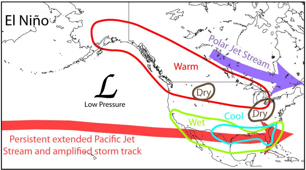
Why is it important for us? Well, it does tend to give the southern tier of the
U.S. a bit of a wetter winter, and also a bit cooler here in the Southern
Plains and the Southeast.


During El Nino events, the pacific jet streak tends to straighten and get pulled
to the south. The warm waters in the region forms storms farther to the south
off the coast of California and those systems then travel across the southern
U.S. Hence, an increased probability of above normal precipitation. Remember,
however, that the atmosphere is not always this simple. Not all El Ninos
play out the same way...the odds are simply stacked a bit more towards this
type of behavior.

If we do happen to end up with ENSO-Neutral conditions, all bets are off.
Supposedly we would then get a more "normal" (but less predictable) winter
season.

"Normal"...whatever the heck that is!

Gary McManus
Associate State Climatologist
Oklahoma Climatological Survey
(405) 325-2253
gmcmanus@mesonet.org
April 20 in Mesonet History
| Record | Value | Station | Year |
|---|---|---|---|
| Maximum Temperature | 98°F | GRA2 | 2022 |
| Minimum Temperature | 24°F | BOIS | 2021 |
| Maximum Rainfall | 2.74″ | VINI | 2025 |
Mesonet records begin in 1994.
Search by Date
If you're a bit off, don't worry, because just like horseshoes, “almost” counts on the Ticker website!