Ticker for April 19, 2012
MESONET TICKER ... MESONET TICKER ... MESONET TICKER ... MESONET TICKER ...
April 19, 2012 April 19, 2012 April 19, 2012 April 19, 2012
Drought fading fast, and the tornado/heavy rain correlation
The latest U.S. Drought Monitor map released this morning shows 75% of the
state now without any sort of dry designation. For those playing along at home,
we'll call that designation "D-nada" to go along with the D0-4 intensity scale.
The D-nada designation rose about 8% from last week's 67% mark.
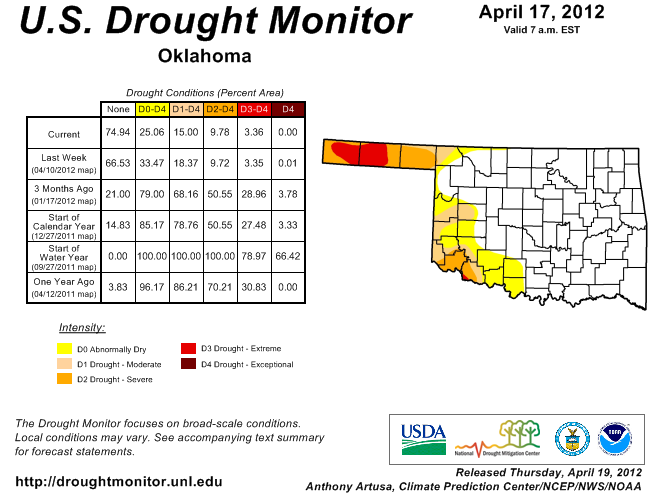
Sort of beating-a-dead-horse territory, but it is worth repeating ... at the
start of the water year on October 1, 2011, 66% of the state was covered by
exceptional (D4) drought, the worst designation on the drought intensity scale.
One year ago at this time, 85% of Oklahoma was suffering from at least abnormally
dry conditions. The current week's improvement was a result of the severe storms
of last weekend. We'll talk more about that in a minute.
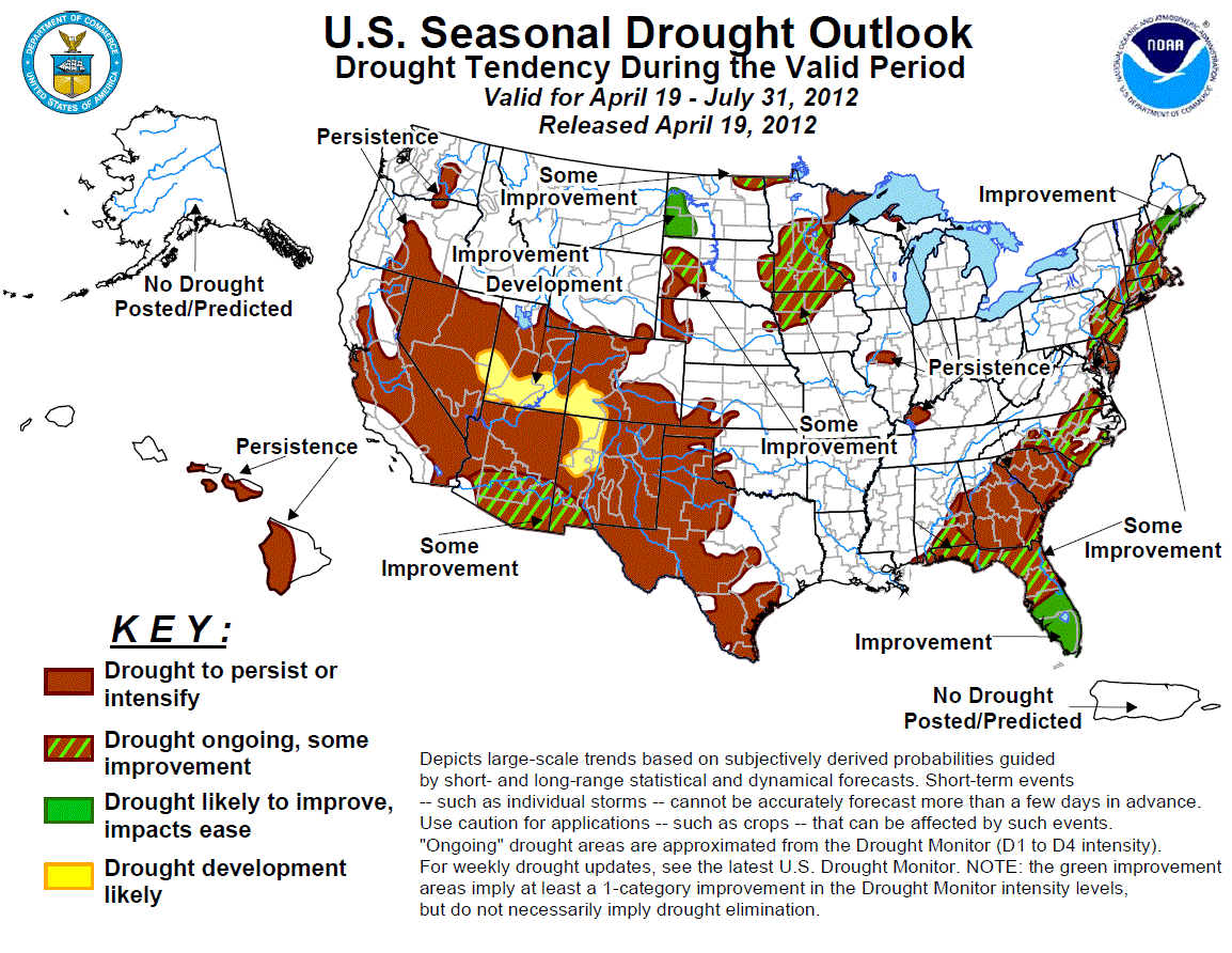
The latest U.S. Seasonal Drought Outlook from the NWS' Climate Prediction Center
(CPC) shows drought persisting through July in those parts of the state where it
already exists. No development is expected by the CPC where drought has been
alleviated for the rest of the state, so good news there.
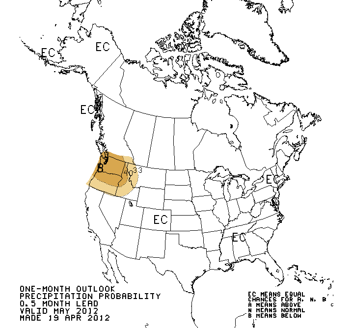
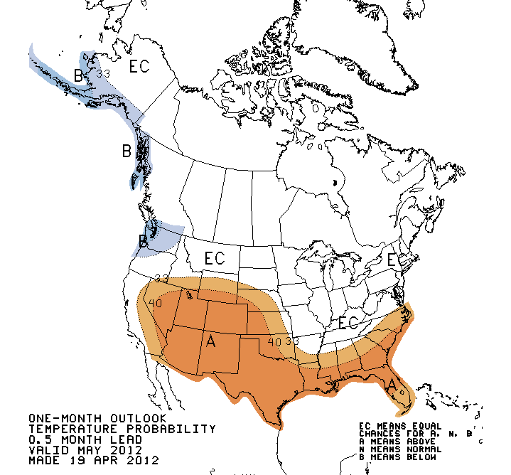
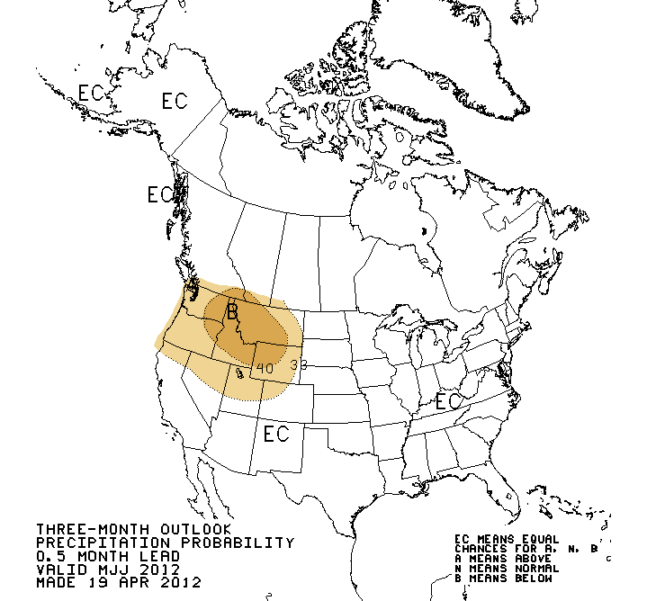
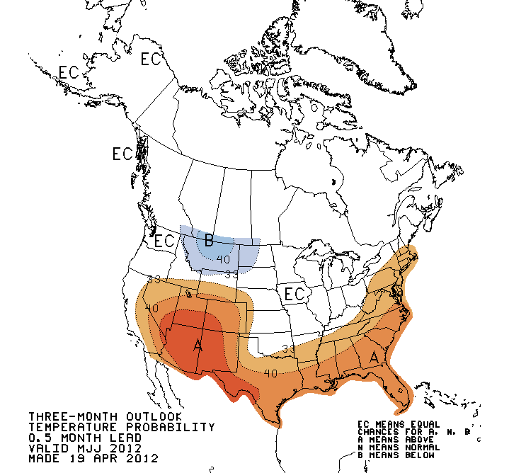
That assessment is generally based on the CPC outlooks for temperature and
precipitation for May and for the May-July period. In short, warmer than
normal weather in the southern High Plains is expected to increase evaporation
demands and aid the persistence of drought conditions. I would have to consider
this outlook to be one of low confidence, since the precip and temperature
outlooks lack much skill as we get into the warmer part of the year. Here are
the outlooks. They reflect the last of the impacts of the fading La Nina. Those
impacts generally become much weaker in the warm months, regardless of the
strength of La Nina (or El Nino). Again, skill drops considerably in the warm
season, and even more so without a strong ENSO signal. Summertime heat is
strongly correlated with summertime precipitation, and summertime precipitation
is incredibly difficult to forecast even in medium time scales.
May
May-July
***********************************************************
The tornadoes stay mainly in the rain in Oklahomain
The latest estimate from NWS-Norman tornado guru Doug Speheger shows 25
confirmed tornadoes for Oklahoma thus far this year. All of those have been
in March and April with counts of five and 20, respectively. Those numbers are
still very preliminary, but they are more likely to go up than down with
further review. As any Okie worth their salt knows, springtime rainfall in
Oklahoma comes with thunderstorms, and some of those thunderstorms will be
severe, and some of those severe thunderstorms will spawn tornadoes. The
heavy rainfall-tornado correlation has worked out a little too well this year.
Take a gander at these March 1-April 19 rainfall maps from the Oklahoma Mesonet.
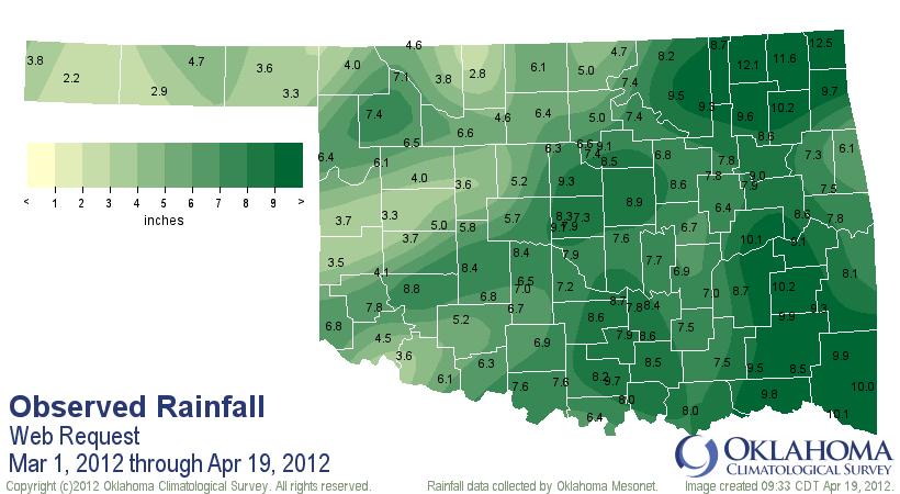
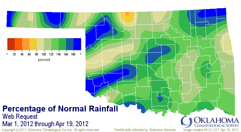
In general, if you are in one of those areas with the 160-200 percent of
normal rainfall, you were in twister territory during the last two months. Take
a look at this modified percent normal rainfall map with tornado numbers
thrown on there.
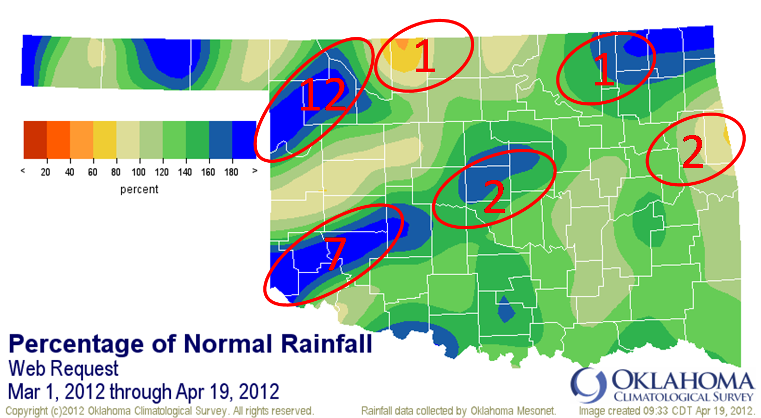
Verrrrrrry interesting. Texas County, you got lucky!
Gary McManus
Associate State Climatologist
Oklahoma Climate Survey
(405) 325-2253
gmcmanus@mesonet.org
April 19 in Mesonet History
| Record | Value | Station | Year |
|---|---|---|---|
| Maximum Temperature | 95°F | HOLL | 2023 |
| Minimum Temperature | 21°F | BOIS | 2013 |
| Maximum Rainfall | 4.77″ | NEWP | 2025 |
Mesonet records begin in 1994.
Search by Date
If you're a bit off, don't worry, because just like horseshoes, “almost” counts on the Ticker website!