Ticker for March 22, 2012
MESONET TICKER ... MESONET TICKER ... MESONET TICKER ... MESONET TICKER ...
March 22, 2012 March 22, 2012 March 22, 2012 March 22, 2012
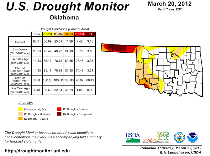
Drought Ends for Much of Oklahoma
Heavy rain associated with this week?s slow-moving storm system brought one
hazard back to the state, even as it was ending another. The abundant moisture
produced flooding in eastern and central Oklahoma, but also alleviated drought
impacts that had plagued the state over the last 19 months. The result was a
much-improved Oklahoma drought picture. According to the latest U.S. Drought
Monitor report released Thursday morning, the area of the state completely free
of drought or abnormally dry conditions rose from 27 percent last week to 63
percent this week. At the drought?s zenith in September 2011, the entire state
was suffering some level of drought. At that point, having just exited the
hottest summer on record for any state dating back to 1895, 69 percent of
Oklahoma was mired in exceptional drought, the U.S. Drought Monitor?s worst
category. This week's report is the best for Oklahoma since October 5, 2010,
when 66 percent of the state had no drought or abnormally dry conditions.
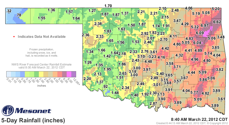
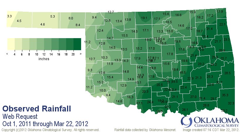
According to data from the Oklahoma Mesonet, rainfall totals of 4-6 inches were
common throughout the eastern half of the state for Monday through Thursday
morning. Estimated totals from radar indicate some localized areas in the
northeast received more than 8 inches. Virtually the entire state received at
least an inch of rain, with more general amounts of 2-4 inches spread
throughout western and central Oklahoma. The Mesonet site at Pryor led totals
with 6.95 inches. With rain continuing to fall, only three of the Mesonet?s 120
stations failed to record at least an inch of rainfall, and unfortunately they
are located in areas of the state still hit hard by drought impacts. Kenton has
had a paltry-but-welcome quarter-inch of moisture in the far western Panhandle.
Its neighbor Boise City and Tipton in far southwestern Oklahoma received around
three-quarters of an inch. Fifty-nine Mesonet sites recorded at least 3 inches
of rain through Thursday morning, with 33 of those reporting more than 4 inches.
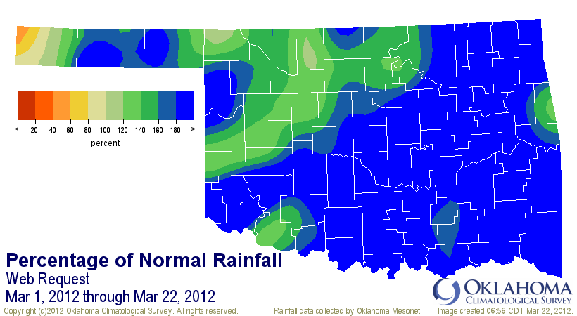
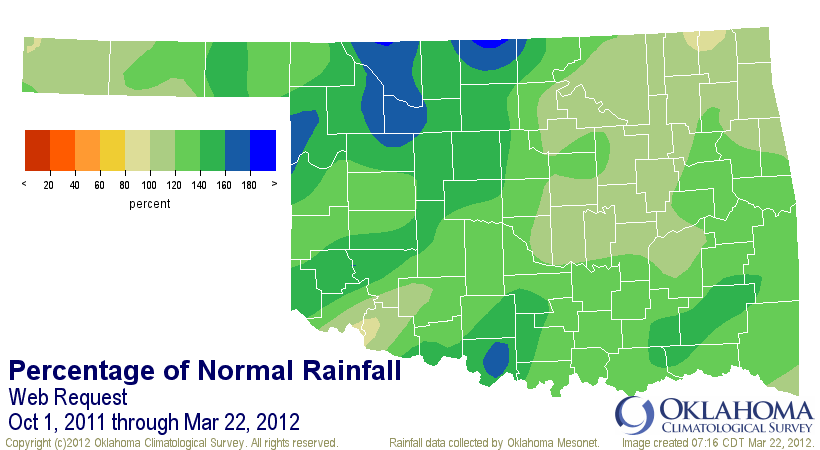
The statewide average going into Thursday morning stood at 4.3 inches, 2.1
inches above normal. That ranks the month already as the 10th wettest March on
record with more than a week left to go, and the 13th wettest January-March
period.
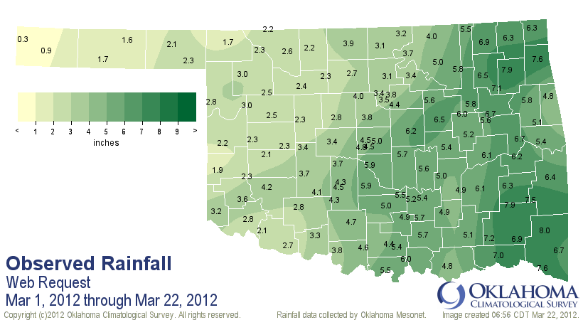
The drought was just getting a toehold in March 2011, which ended as the eighth
driest on record with a statewide average of 0.71 inches. The relief this March
continues the momentum of drought eradication that began in October 2011. Since
that time, also known as the start of the water year, the state has received an
average of 17.3 inches of rain, a surplus of 3.6 inches. The water year runs
from Oct. 1-Sep. 30. The water year thus far is the 12th wettest on record,
compared to the same period last year, which was the seventh driest.
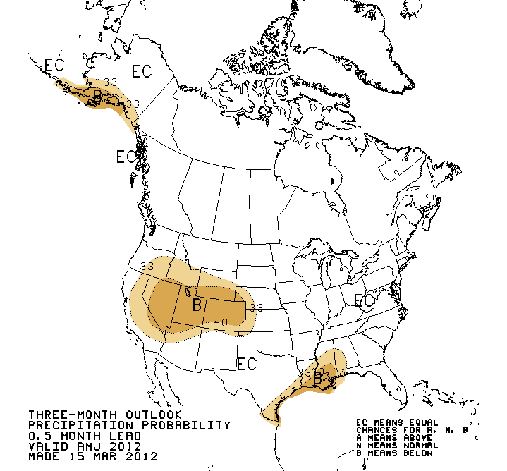
The outlooks for April-June from the National Weather Service?s Climate
Prediction Center are uncertain about Oklahoma?s precipitation chances through
that period. They indicate equal chances of below-, above- or near-normal
precipitation, meaning no clear climate signal exists to tip the forecast in
one direction. Two of those possibilities would be favorable for Oklahoma.
Anything but below normal rainfall will continue to alleviate existing drought
impacts, and prevent more drought from developing.
Gary McManus
Associate State Climatologist
Oklahoma Climatological Survey
(405) 325-2253
gmcmanus@mesonet.org
March 22 in Mesonet History
| Record | Value | Station | Year |
|---|---|---|---|
| Maximum Temperature | 92°F | WALT | 2011 |
| Minimum Temperature | 12°F | MEDF | 2002 |
| Maximum Rainfall | 3.70 inches | PUTN | 2007 |
Mesonet records begin in 1994.
Search by Date
If you're a bit off, don't worry, because just like horseshoes, “almost” counts on the Ticker website!