Ticker for March 20, 2012
MESONET TICKER ... MESONET TICKER ... MESONET TICKER ... MESONET TICKER ...
March 20, 2012 March 20, 2012 March 20, 2012 March 20, 2012
Heavy rains and flooding pound eastern half of state
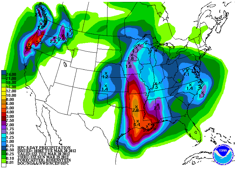
Rainfall totals have continued to increase as the upper-level low pressure system
responsible for this mess meanders about to the west of us. Who can blame it? I
hear New Mexico is lovely this time of year. The problem, of course, is that it
has continued to dump more and more rain across the eastern half of the state ...
more rain than that area can handle. Mesonet rainfall totals through 9:15 a.m.
show the damage being done in eastern Oklahoma, where rain continues to fall.

The highest total measured by the Mesonet is 6.1 inches at Pryor (again, rain
continues to fall in that area), but the radar-estimated totals look to have gone
as high as 8 inches just to the east of that area. Those higher totals appear
fairly widespread. Down into central Oklahoma, Norman led the way with 4.11
inches.
Here are the top 20 totals from the Mesonet for this event (remember, rain still
falling!):
-****-
Pryor 6.10" Eufaula 4.40"
Jay 5.48" Hugo 4.40"
Porter 5.33" Vinita 4.35"
Inola 5.08" Nowata 4.22"
Antlers 5.01" Wilburton 4.21"
Clayton 4.94" Haskell 4.18"
Hectorville 4.65" Chandler 4.13"
Bristow 4.53" Okmulgee 4.11"
Bixby 4.46" Norman 4.11"
Claremore 4.44" Miami 4.02"
-***-
That's an incredible amount of rain in such a short time period. Most of that
has fallen in the last 24 hours, prompting widespread flood warnings of all
varieties (flash and river) in the eastern half of the state. The statewide
average total is now up to 3.69 inches for March, 1.71 inches above normal and
already tied for the 22nd wettest March since records began in 1895 ... with
more rain on the way! Last March was the eighth driest on record, if you will
recall. The wettest March on record for the state is 1973's 7.46 inches.
The one area of the state lagging far behind for this system is also the area
that needs it the most - the Panhandle. Boise City, Goodwell, Hooker and Kenton
have yet to receive rain during this event, and less than a quarter of an inch
for the month. There is still hope for those folks, however, as the upper-level
low moves across the state. Forecast amounts as high as an inch exist for that
region over the next couple of days (and even more for northern and eastern
Oklahoma as well).
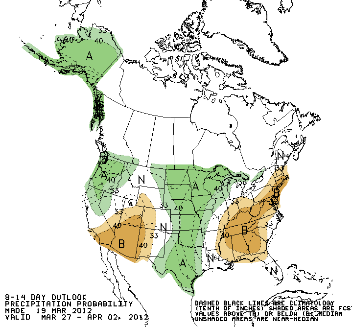
And don't look now, but the NWS' Climate Prediction Center sees increased
chances for above normal precipitation during the 8-14 day period (March 27-
April 2) as well.
So batten down the hatches! Might as well hatten the batches while you're at it.
Oklahoma's wild weather ride appears to be back in service.
Please keep your hands inside the ride at all times. Thank you.
Gary McManus
Associate State Climatologist
Oklahoma Climatological Survey
(405) 325-2253
gmcmanus@mesonet.org
March 20 in Mesonet History
| Record | Value | Station | Year |
|---|---|---|---|
| Maximum Temperature | 98°F | BUTL | 2017 |
| Minimum Temperature | 8°F | KENT | 2016 |
| Maximum Rainfall | 5.14 inches | FORA | 2007 |
Mesonet records begin in 1994.
Search by Date
If you're a bit off, don't worry, because just like horseshoes, “almost” counts on the Ticker website!