Ticker for March 19, 2012
MESONET TICKER ... MESONET TICKER ... MESONET TICKER ... MESONET TICKER ...
March 19, 2012 March 19, 2012 March 19, 2012 March 19, 2012
Hydrometeorological meteors striking the earth in a tumultuous fashion
Yep, it's finally raining and it's raining hard. The highest totals thus far have
been scattered across western Oklahoma. Mangum leads the pack as of 9:50 a.m.
on this fine Monday morning with 1.74 inches. The Mesonet rainfall map with the
radar estimated overlays show the totals in localized areas in the southwest
approached 3 inches. Unfortunately, it looks like the part of the state hit
hardest by drought, the western two-thirds of the Panhandle, might have rolled
snake-eyes once again.
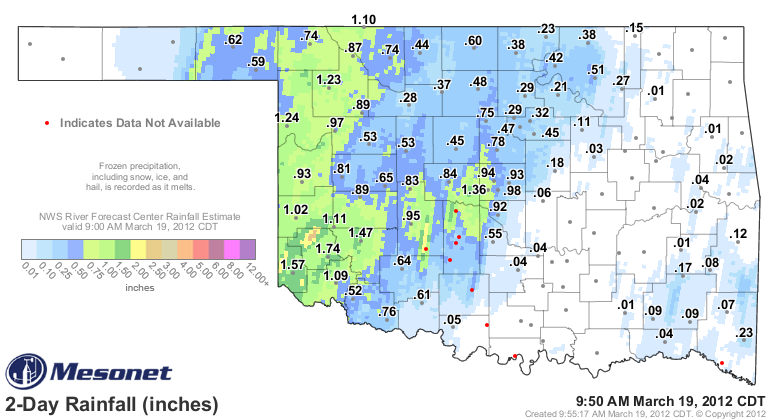
Even Beaver County in the Panhandle got into the act with 0.5-0.75 inches. Those
numbers will continue to grow to the east over the next 24-48 hours. A good 4-8
inches of rainfall will be possible in eastern Oklahoma, raising concerns for
flash flooding. Much of eastern Oklahoma is therefore under a flash flood watch
through Wednesday morning. Localized amounts of up to 15 inches will be possible.
"WIDESPREAD RAINFALL AMOUNTS FROM 4 TO 8 INCHES ARE EXPECTED
ACROSS A GOOD PORTION OF EASTERN OKLAHOMA AND NORTHWEST
ARKANSAS. ISOLATED AREAS COULD RECEIVE RAINFALL AMOUNTS BETWEEN
A FOOT AND 15 INCHES. WIDESPREAD AND POTENTIALLY CATASTROPHIC
AREAL FLOODING AND RIVER FLOODING WOULD RESULT SHOULD THESE AMOUNTS
MATERIALIZE.
This graphic from our friends at the NWS Tulsa Forecast Office paints a very
un-pretty picture.
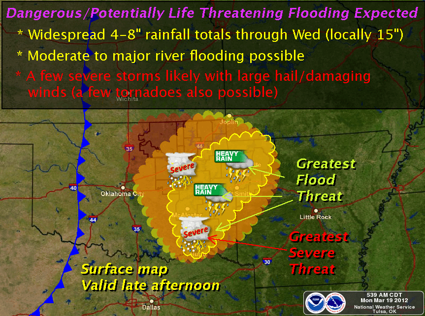
Notice the tornado threat. Oklahoma's tornado count for 2012 finally got rolling
with a preliminary total of four twisters yesterday, all in Greer County. Last
year's total seems to be solidifying at 119, second most since records began
in 1950, so 2012 has a long way to go.
You can track all of the rainfall in your local-locality on our Mesonet website:
http://www.mesonet.org/index.php/weather/category/rainfall
************************************************************
Finally, the Mesonet site at Walters (WALT) is now the site formerly known as
Walters. We do have a new site down there, however, so Walters fans can quit
worrying. The new site will be known as "WAL2" (sorry, WALL-E was taken). Here
are some particulars.
Walters (WAL2)
* Station Number: 136
* Location: 4 miles NW of Walters
* County: Cotton
* Latitude: 34.399570? / 34? 23' 58" N
* Longitude: -98.345690? / 98? 20' 44" W
* Elevation: 323 meters above Mean Sea Level
Gary McManus
Associate State Climatologist
Oklahoma Climatological Survey
(405) 325-2253
gmcmanus@mesonet.org
March 19 in Mesonet History
| Record | Value | Station | Year |
|---|---|---|---|
| Maximum Temperature | 97°F | BEAV | 2017 |
| Minimum Temperature | 5°F | EVAX | 2023 |
| Maximum Rainfall | 4.46 inches | PRYO | 2012 |
Mesonet records begin in 1994.
Search by Date
If you're a bit off, don't worry, because just like horseshoes, “almost” counts on the Ticker website!