Ticker for March 16, 2012
MESONET TICKER ... MESONET TICKER ... MESONET TICKER ... MESONET TICKER ...
March 16, 2012 March 16, 2012 March 16, 2012 March 16, 2012
March temperatures out of control, and western Oklahoma rain shield ... activate!
There are two rules in talking about rain chances for western Oklahoma:
1. Do not talk about rain chances for western Oklahoma.
2. DO NOT TALK ABOUT RAIN CHANCES FOR WESTERN OKLAHOMA!
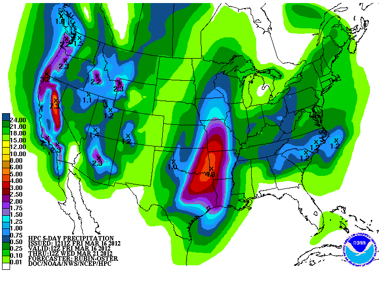
The latest forecasts for next weeks rain event have begun to shift those rain
chances to the east. The 5-day precipitation total from the NWS' HPC now has the
biggest bullseye in far southeastern Oklahoma. There is still a good 1-2 inches
through central Oklahoma and a coat hook of an inch or so up into the northwest,
at least through next Wednesday morning.
This will change. I still have hope that it can shift back to the west,
and there is a chance of convective precip over the next few days before the
big event. Unfortunately, it does not look widespread.
The big story lately has been the ridiculous temperature regime we've had
thrust upon us. At this point, best to just quit worrying about a later freeze
and enjoy it. With half of the month gone now, we can look at some numbers.
According to preliminary data from the Oklahoma Mesonet, the statewide average
temperature for March 1-15 was 55.5 degrees. Doesn't sound too impressive until
you compare it to normal.
-****-
Max Temps Min Temps Mean Temps
Statewide Avg. 68.7 42.4 55.5
Normal 60.5 34.6 47.6
Departure 8.2 7.8 7.9
-***-
Now we're talking ... the statewide average temperature for the first half of
March was 7.9 degrees above normal, split just about evenly between highs and
lows. The warmest March on record in Oklahoma, based on statewide average, was
2007's 58.3 degrees. This March at 55.5 degrees would be the seventh warmest
on record, but it has lots of time to warm up some more.

Now many of you, especially in agriculture, will recall what happened after
that warm March in 2007. We ended up with the eighth COOLEST April on record
with an average of 55.2 degrees, only the second time since 1895 that April
was more cool than March. Made even more odd by the fact that April 2006 was
the warmest April on record! So lots of topsy-turvy temperatures going on. It's
Oklahoma, what else is new. But that April cool-down in 2007 did tremendous
amounts of damage to Oklahoma's wheat and orchard crops with a couple of big
freeze events.
Wait a minute, I'm not done! That was followed quickly by easily the wettest
June on record in the state with an average of 9.84 inches, which led to the
wettest SUMMER on record for the state with an average of 18.02 inches.
The point? Well, I think I lost that a long time ago, but here's something to
consider. Trying to extrapolate the next month's or even season's weather
is not always the best plan of action. The summer of 2007 was actually below
normal temperature wise following that warm March, but also important to
remember that Oklahoma summertime temps are strongly governed by rainfall.
Back to March for a minute - comparing the Oklahoma Mesonet numbers to daily
records from the closely-located NWS COOPerative stations indicates a lot of
records have no doubt fallen in the first 15 days of March. Again, not official
since we're comparing Mesonet to COOP, but according to that comparison as
many as 202 locations across the state have either broken or tied records on
the warm side of the thermometer. Of those 202 temperature records, 187 were
for highest minimum temperatures and only 15 were for highest maximum
temperatures. This morning had widespread highest minimum temperature records
that look to have been broken but are not included in those counts.
Now if we kept out temperature of 55.5 for the rest of March (even though it
looks as if it will keep rising), that will be good for the fourth-warmest first
three months of the year since 1899. The Jan-March period of 1986 leads the
list with an average of 47.7 degrees. This year's would be 47.2 degrees. That
record may fall in addition to March's.
So after the warmest summer on record in 2011, not only for Oklahoma but the
entire United States, and the 11th-or-so warmest winter this year, we may look
at this coming summer with a bit of trepidation. Watch the precipitation
patterns though, a much more important predictor of Oklahoma summer temperature
patterns than early-year warmth.
Gary McManus
Associate State Climatologist
Oklahoma Climatological Survey
(405) 325-2253
gmcmanus@mesonet.org
March 16 in Mesonet History
| Record | Value | Station | Year |
|---|---|---|---|
| Maximum Temperature | 91°F | BEAV | 2015 |
| Minimum Temperature | 11°F | BOIS | 2005 |
| Maximum Rainfall | 3.01 inches | CALV | 1998 |
Mesonet records begin in 1994.
Search by Date
If you're a bit off, don't worry, because just like horseshoes, “almost” counts on the Ticker website!