Ticker for March 15, 2012
MESONET TICKER ... MESONET TICKER ... MESONET TICKER ... MESONET TICKER ...
March 15, 2012 March 15, 2012 March 15, 2012 March 15, 2012
Drought's lifeboat taking on water
Listen (or read), I will admit I'm not the best forecaster in the world. I
realized that pretty quickly after my first few attempts at prognosticating the
weather. I'm much better off telling folks what happened AFTER an event
instead of before. But even I can see we have a pretty good rain on the way for
early next week. And this comes after the rain of last week that has once again
dealt a fairly serious body blow to the drought of 2010-12. The latest U.S.
Drought Monitor map reflects the changes due to the rains from that slow-moving
system that struck last Wednesday-Sunday.
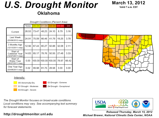
Major improvements occurred across most of the northwestern half of the state,
save for the Panhandle. The amount of extreme-exceptional (D3-D4) drought dropped
from 19% to 9%. Severe-exceptional (D2-D4) drought dropped from 42% to 24%, and
drought of any kind, moderate-exceptional (D1-D4), sunk to 48% of the state.
That's a change from last week's 66% of the state in drought. Unfortunately, the
Panhandle continues to languish in extreme-exceptional drought. The last rain
event was not kind to most of that area with less than a quarter of an inch
in Cimarron and Texas Counties and about a half of an inch in Beaver County.
More great news comes from the CPC forecasters with their latest U.S. Seasonal
Drought Outlook, released this morning. It reflects the possibility for that
rain system next week with "Drought likely to improve, impacts ease" for
the main body of the state. The eastern third of the Panhandle gets into the
act with the "some improvement" tag.

The reasoning, from CPC forecaster (and former OCS grad student) Brad Pugh:
"As an upper-level trough progresses from the western conus, another
round of beneficial rainfall is expected across the central/southern
Great Plains during latter half of March. Due to elevated odds for
above median precipitation forecast during the day 6-10 period and a
relatively wet climatology during the outlook period, improvement
can be expected across parts of the central/southern Great Plains."
So while that trough that is expected to progress from the western conus (and
we all know just how painful that can be), please keep in mind that it is not
even over land yet where it can be better sampled by instruments, and therefore
better forecast. In the next few days, the exact locations of the heavy rains
will come into better focus.
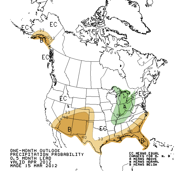
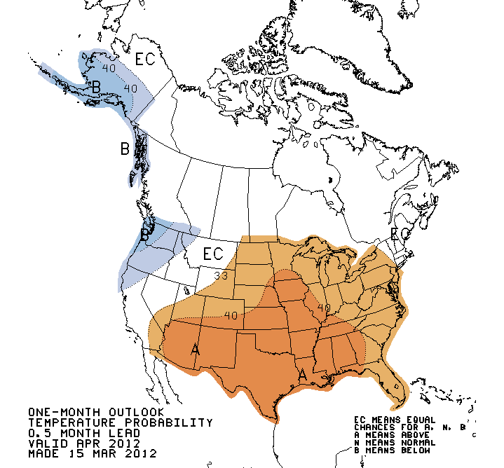
The latest April and April-June outlooks were also released by the CPC. Now that
we're approaching the warm season, and La Nina continues to fade, their
skill will diminish quite rapidly. That is reflected in the April-June outlooks.
For April itself, however, the familiar pattern remains with increased chances
of above normal temperatures across the entire state, and increased odds of
below normal rainfall in the Panhandle.
April
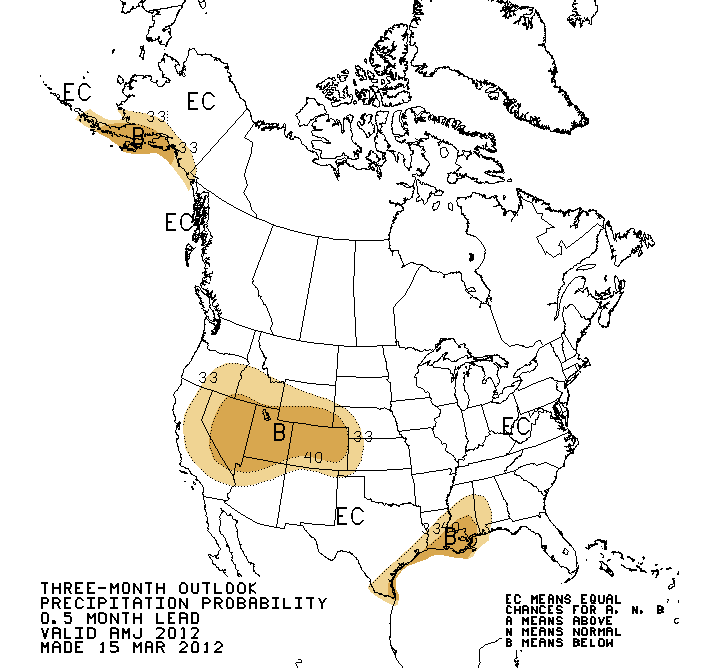
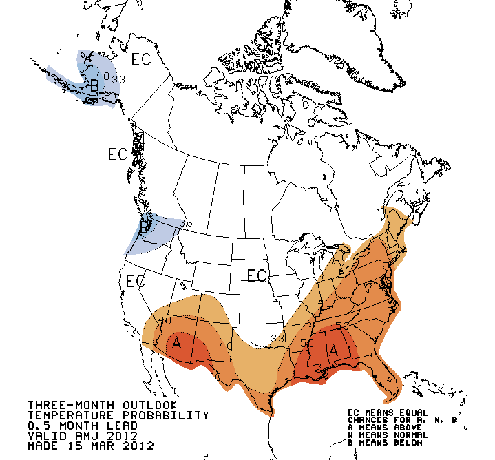
For the April-June period, 95% of the state is painted in the "EC" or "Equal
Chances" area, a reflection of the outlooks' lack of skill (meaning there are
no forecast tools available to favor above-, below- or near-normal outlooks).
A similar outlook was produced for the April-June temperature outlook.
April-June
Bring on the rain! To heck with a possible jinx, or a change in the forecast.*
* Note: Not responsible for jinxes or changes in forecast.
Gary McManus
Associate State Climatologist
Oklahoma Climatological Survey
(405) 325-2253
gmcmanus@mesonet.org
March 15 in Mesonet History
| Record | Value | Station | Year |
|---|---|---|---|
| Maximum Temperature | 88°F | ALV2 | 2013 |
| Minimum Temperature | 14°F | SLAP | 1997 |
| Maximum Rainfall | 3.96 inches | WILB | 2014 |
Mesonet records begin in 1994.
Search by Date
If you're a bit off, don't worry, because just like horseshoes, “almost” counts on the Ticker website!