Ticker for March 1, 2012
MESONET TICKER ... MESONET TICKER ... MESONET TICKER ... MESONET TICKER ...
March 1, 2012 March 1, 2012 March 1, 2012 March 1, 2012
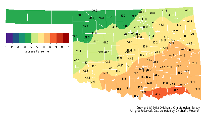
Warm February Closes Out Eleventh Warmest Winter in Oklahoma
Golf clubs replaced parkas as the outdoor accessory of choice this winter, and
Oklahoma?s kids can only dream of missed school days filled with sledding and
snowball fights. The mildness of this winter ? the 11th warmest on record at
nearly 3 degrees above normal ? stands in stark contrast to the cold, snowy
experiences of the previous two years. The winter of 2009-10 was the state?s
seventh coldest on record at more than 4 degrees below normal. Statewide average
records date back to 1895. Oklahoma City and Tulsa both recorded approximately 23
inches of snow that cool season. The snow was plentiful last winter as well.
Tulsa measured the highest seasonal snowfall total in its history with 26.1
inches, and the small town of Spavinaw broke the all-time state record for
24-hour snowfall with 27 inches. Tulsa has recorded a paltry 1.7 inches of snow
so far this cool season and Oklahoma City reported a similar total of 1.8 inches.
The all-time state record minimum temperature also fell last year with a reading
of minus 31 degrees at Nowata on Feb. 10. Across the 120-station Oklahoma
Mesonet weather network, 266 below-zero temperatures were recorded last winter
compared to just four such readings this winter. This winter ranked as the
ninth warmest in Oklahoma City dating back to 1891. Tulsa?s average winter
temperature tied for the sixth warmest dating back to 1905.
*note: Mesonet temperature maps are missing data in the Panhandle due to
technical difficulties
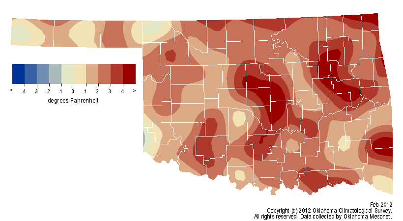
Winter Temperatures

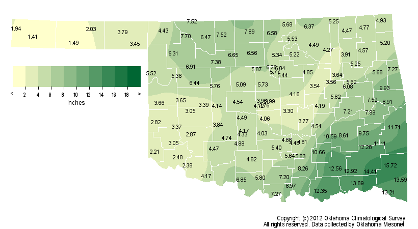
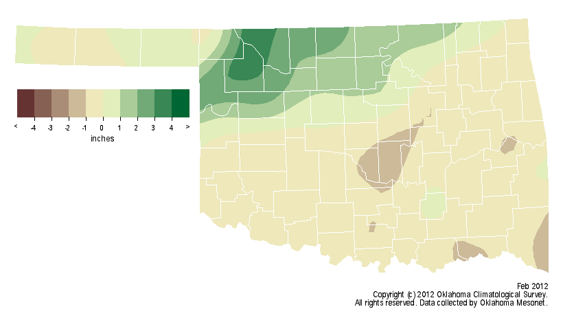
Winter Precipitation
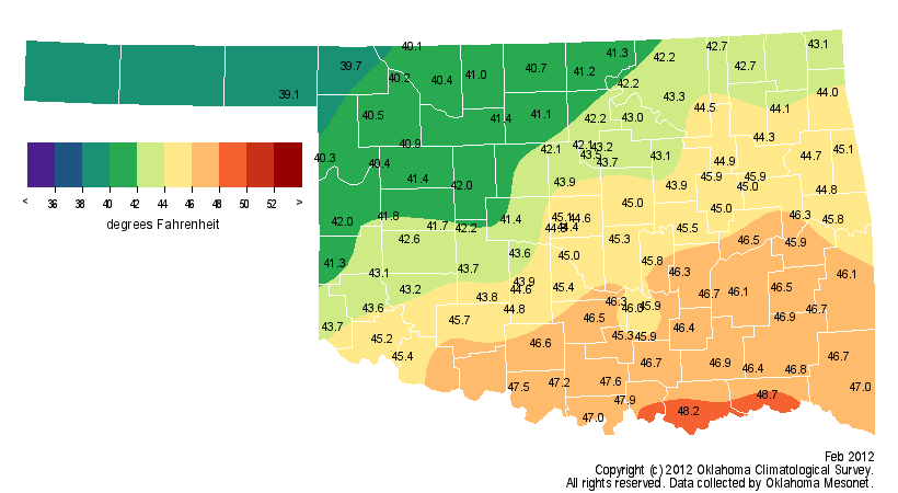
At 2 degrees above normal across the state, February?s warmth was not quite as
striking as the previous two winter months, but it still managed to rank as the
33rd warmest February on record. The statewide average precipitation total of
1.78 inches was virtually normal and ranked as the 42nd wettest February on
record. Much of the state was actually a bit on the dry side, but the fourth
wettest February on record for north central Oklahoma helped boost the
statewide average. This winter was the second wettest on record for north
central Oklahoma with an average total of 6.84 inches, a surplus of 3.39 inches.
Statewide, this winter was the 30th wettest with an average of 6.08 inches,
0.85 inches above normal.
February Temperatures
February Precipitation


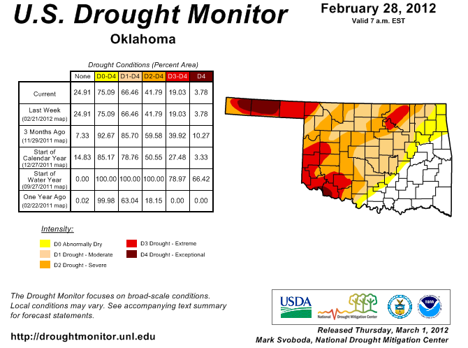
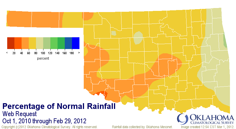
The abundant moisture over the last several months helped alleviate drought
conditions that have existed since October 2010. The most recent U.S. Drought
Monitor report, released March 1, reveals 66 percent of the state remains in
some level of drought, as opposed to 93 percent at the end of November 2011.
The most severe drought conditions remain in the Panhandle and southwestern
Oklahoma, where agricultural producers have expressed concerns of another
dismal year if rains fail to materialize soon. Much of southeastern and east
central Oklahoma is completely free of drought thanks to beneficial rains over
the last several months. On the opposite side of the state, parts of the
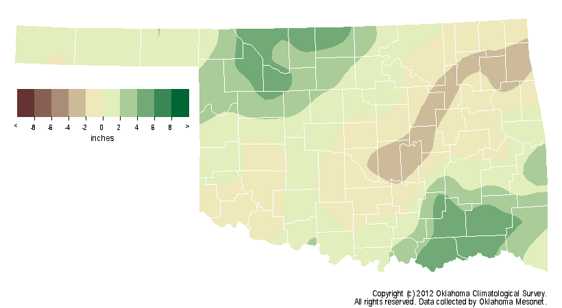
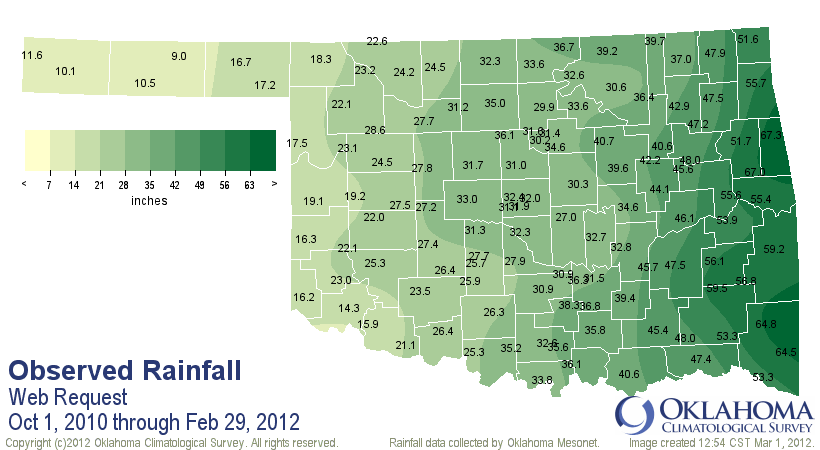
Oklahoma Panhandle have received less than 10 inches of rain in the 17 months
since the start of October 2010.
US Drought Monitor
October 2010-February 2012 precipitation totals
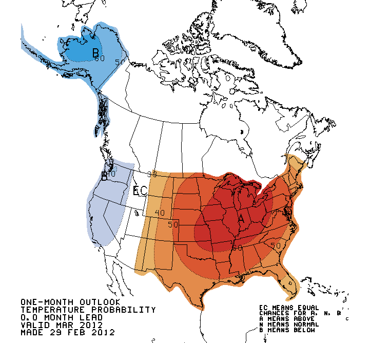
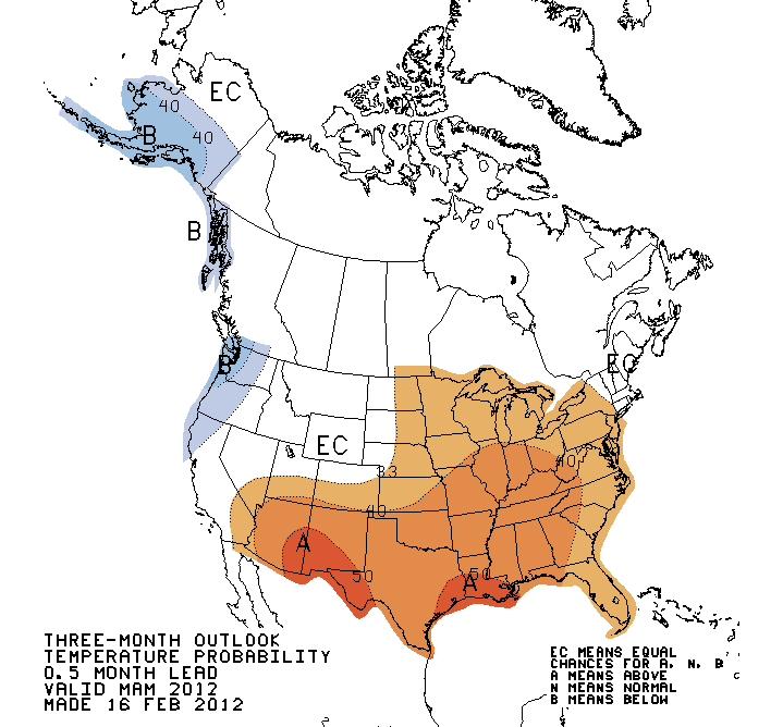
The temperature outlook from forecasters at the National Weather Service?s
Climate Prediction Center (CPC) is for the unusual warmth of winter to bleed
right into March and continue through spring for much of the eastern two-thirds
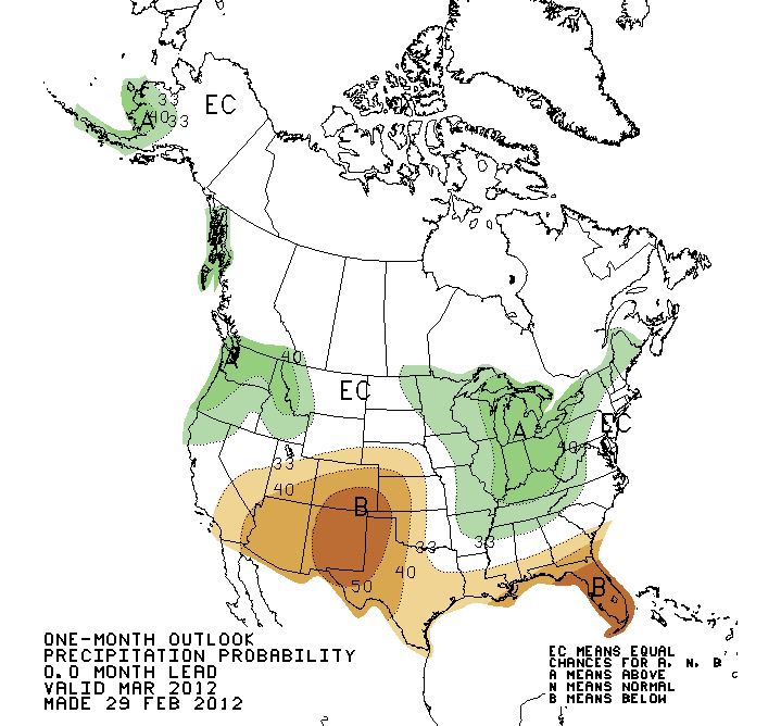
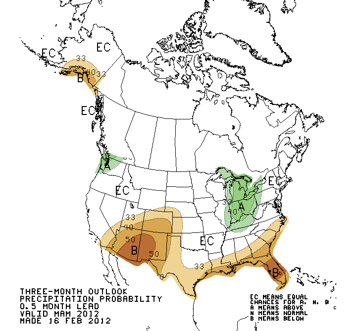
of the United States. The precipitation outlook calls for increased chances of
below normal precipitation across the western half of Oklahoma for March and
for the Panhandle and extreme western Oklahoma through spring. Equal chances
for above-, below- and near-normal precipitation exist for the rest of the
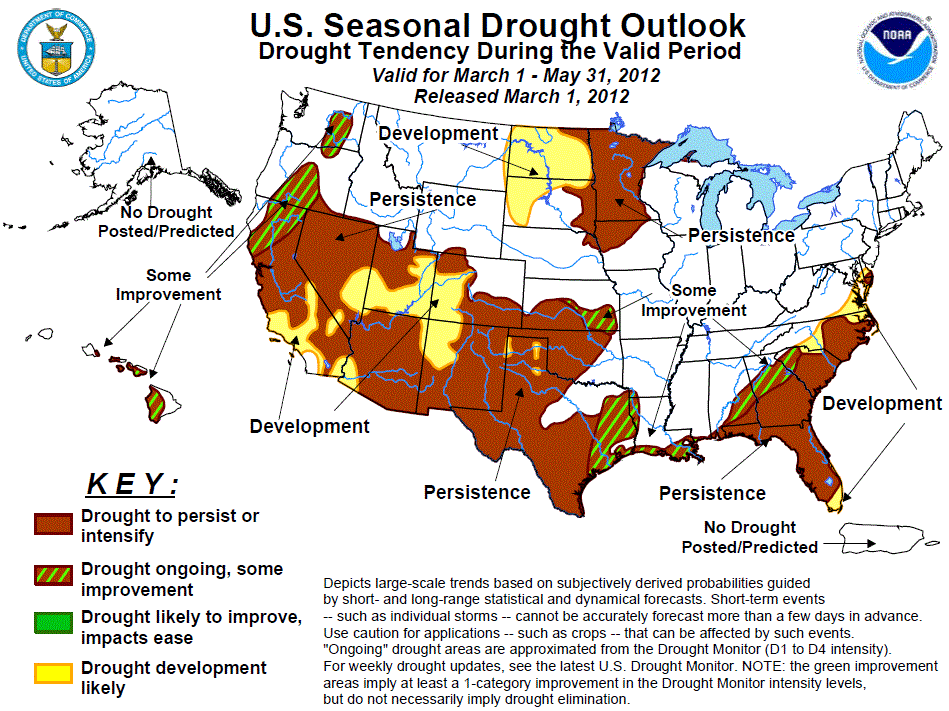
state. Unfortunately, the latest Seasonal Drought Outlook from the CPC reflects
those chances for warmer and drier weather over the next three months. That
outlook calls for the persistence or intensification of drought conditions
through May for much of western, northern and central Oklahoma.
March Outlooks
March-May Outlooks
CPC Seasonal Drought Outlook
Gary McManus
Associate State Climatologist
Oklahoma Climatological Survey
(405) 325-2253
gmcmanus@mesonet.org
March 1 in Mesonet History
| Record | Value | Station | Year |
|---|---|---|---|
| Maximum Temperature | 95°F | NEWP | 2006 |
| Minimum Temperature | 7°F | GOOD | 2001 |
| Maximum Rainfall | 1.86 inches | HUGO | 1997 |
Mesonet records begin in 1994.
Search by Date
If you're a bit off, don't worry, because just like horseshoes, “almost” counts on the Ticker website!