Ticker for March 6, 2012
MESONET TICKER ... MESONET TICKER ... MESONET TICKER ... MESONET TICKER ...
March 6, 2012 March 6, 2012 March 6, 2012 March 6, 2012
One gullywasher, coming up!
Looks like we have our first really slow-moving upper-level storm of the spring
on tap for the next few days. With any luck, it will sit out over the Four Corners
area spinning and pumping moisture up over Oklahoma from the Gulf of Mexico. And
apologies in advance for any folks affected by possible flooding, but that
pretty much comes with the territory to get springtime rains in Oklahoma. At
least there is not an indication of widespread severe weather with this episode.
Now given the drought conditions we have across the state, it seems only an idiot
would complain about this storm system. So here are my complaints (you could see
that one coming, right?). First, here is the latest 5-day precipitation forecast
product from the NWS' Hydrometeorological Prediction Center (HPC).
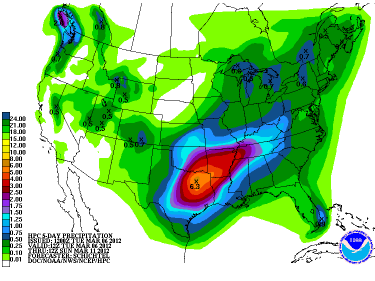
So we can see in that forecast graphic for today through Sunday morning that much
of the eastern half of the state receives about 2-6 inches of rain. Great! Awesome
for those parts of the state that still need it. Still, the western half of
Oklahoma, at least from this forecast, gets about 1.5 inches and less, with the
hardest hit areas in the Panhandle receiving less than a half of an inch. The
Panhandle has seen many many days of above normal temperatures and severe winds
throughout the continuation of their exceptional drought. Any moisture they
receive tends to get blasted out of the soils as soon as it falls.
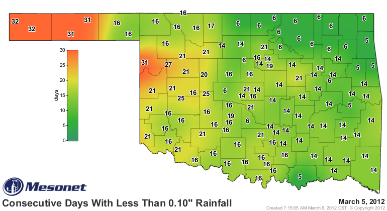
The state has been drying out over the last few weeks, and the winds haven't
helped. These consecutive days without rainfall maps from the Oklahoma Mesonet
tell the story. Pay particular attention to the northwest, however.
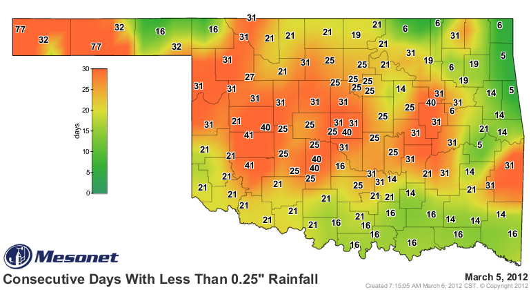
Seventy-seven days without a a quarter of an inch of rainfall in a single day
in the Panhandle and 30-40 days over other areas ... a fairly sad statistic to
say the least. One more day of extreme fire danger until blessed relief. A lot
of damage will be done to the soils in the Panhandle today with winds gusting
to 50 mph, high temperatures in the 80s and relative humidity down in the teens.
Hopefully some of that heavy moisture will shift about 500 miles to the
northwest.
Gary McManus
Associate State Climatologist
Oklahoma Climatological Survey
(405) 325-2253
gmcmanus@mesonet.org
March 6 in Mesonet History
| Record | Value | Station | Year |
|---|---|---|---|
| Maximum Temperature | 87°F | ALV2 | 2017 |
| Minimum Temperature | 9°F | KENT | 2018 |
| Maximum Rainfall | 2.10 inches | COOK | 1995 |
Mesonet records begin in 1994.
Search by Date
If you're a bit off, don't worry, because just like horseshoes, “almost” counts on the Ticker website!