Ticker for February 6, 2012
MESONET TICKER ... MESONET TICKER ... MESONET TICKER ... MESONET TICKER ...
February 6, 2012 February 6, 2012 February 6, 2012 February 6, 2012
More rainy, less wimpy
I know I don't speak for everybody (I actually applied for that job but I didn't
even get an interview), but I was running around on Saturday like I had been
transported to the North Pole with only a t-shirt and shorts to keep me warm.
Rightfully so, of course. After all, wind chills did get down to the bone-
chilling 20s in central Oklahoma! Yes, I have become a wimp. I'll blame it
on the hottest summer for any state in the U.S. since records began in 1895 (and
the hottest month, July 2011, for any state in the U.S. since 1895), the eighth
warmest year in Oklahoma (2011) since 1895, the eight warmest January (2012) and
the 16th warmest December-January. My body, just like a lot of living things
in the area, thought for sure we were headed for springtime already. So after a
brush with the brutal, frigid ... okay, just a tad below normal weather the last
few days, I was left searching for the parka.
The statewide average temperature on Sunday was 38.4 degrees according to the
Oklahoma Mesonet, good for the 23rd coolest day in the state since November 2011.
For no good reason other than I like making tables, here are the 10 coldest days
thus far since November (average temperatures, based on highs and lows averaged
together):
-****-
Date Avg. Temp (F)
2011/12/6 24.7
2012/1/12 28.5
2011/12/7 30.3
2011/12/5 30.7
2011/12/23 31.9
2012/1/18 32.3
2012/1/21 32.7
2011/12/9 33.7
2011/12/10 33.8
2011/12/24 34.2
-***-
By the way, that 24.7 degrees on December 6 would be tied for the 11th coldest
day last winter.
*******************************************************************************
Speaking of springtime, the storms that struck the state late last week did a
world of good up in northwestern Oklahoma. The Oklahoma Mesonet totals and the
NWS River Forecast Center's radar estimated overlay shows a good 3-5+ inches
fell from Arnett up through Wood County, with associated amounts to the east
of 1-3 inches.
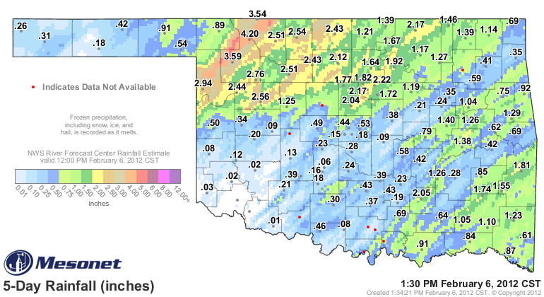
The demarcation between the heavy rains and the not-so-heavy rains is remarkably
tight as you go northwest. Enough that I'm not holding out much hope for relief
at my favorite fishing pond in the light green 0.75 inch area in Harper County.
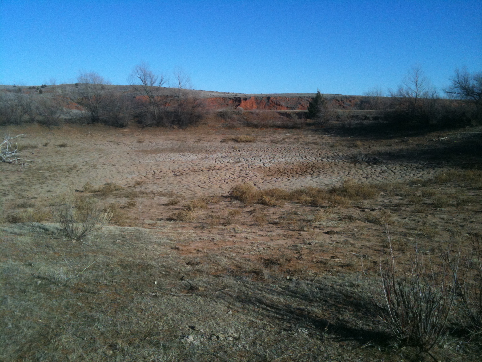
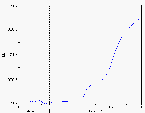
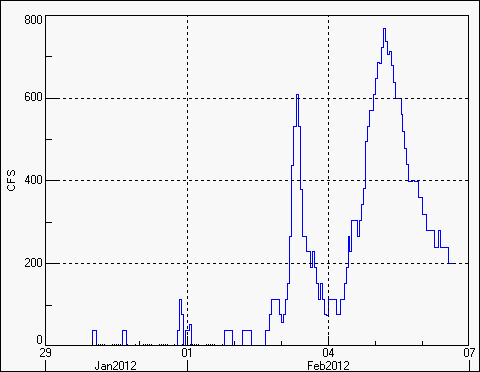
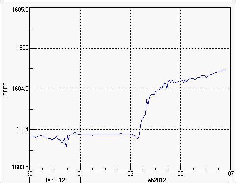
Fort Supply Lake, just to the northwest of that 3.59 inch total at Woodward and
right in the 5+ inches radar estimated rainfall, is now at 95% capacity after
languishing between 60-75% over the last several months. You can see how the
heavy rains upped the inflow and level at Fort Supply using the U.S. Army Corps
of Engineer reservoir level data.
Some other lakes we have been concerned about were not quite as fortunate.
Canton Lake in northwestern Blaine County was in the 2-3 inch radar estimated
area, yet it's level rose only to 32% of capacity, up from 28% just before the
rainfall event.
What is evident is that short-term impacts and concerns due to the drought have
diminished tremendously. There is a lot of soil moisture to work with as we
emerge into spring, befitting crops and pastures. A few areas are still
concerned with those long-term impacts, like reservoir levels. Much of the
central Oklahoma Panhandle is still suffering from both long-term and short-term
concerns, as is far southwestern Oklahoma. Let's hope their turn for a downpour
is next.
Now, with reports of a bit below normal to near normal temperatures (and up to
1.5 inches of snow in the northwest) on the plate for the next few days, I'm
off to find a hole to hibernate.
After stocking up on bread and milk, of course.
Gary McManus
Associate State Climatologist
Oklahoma Climatological Survey
(405) 325-2253
gmcmanus@mesonet.org
February 6 in Mesonet History
| Record | Value | Station | Year |
|---|---|---|---|
| Maximum Temperature | 84°F | BEAV | 2009 |
| Minimum Temperature | 0°F | CAMA | 2014 |
| Maximum Rainfall | 2.59″ | PRES | 1999 |
Mesonet records begin in 1994.
Search by Date
If you're a bit off, don't worry, because just like horseshoes, “almost” counts on the Ticker website!