Ticker for February 9, 2012
MESONET TICKER ... MESONET TICKER ... MESONET TICKER ... MESONET TICKER ...
February 9, 2012 February 9, 2012 February 9, 2012 February 9, 2012
Drought relief in the northwest, La Nina fading away
It's always good to see more white appear on the U.S. Drought Monitor, even as we
get excited about the possibility of more white on the ground around here over
the next several days. However it falls, be it rain or snow, it will be much
welcomed moisture. Freezing rain? Sorry, the inn is full.
The drought map released this morning shows the good work in northwestern
Oklahoma after last week's 3-5 inches of rain. A somewhat rare two-category
improvement from "extreme" to "moderate" drought was indicated from northern
Roger Mills through Woods County. A one-category improvement was also
established from Dewey County up through Grant and Kay Counties.
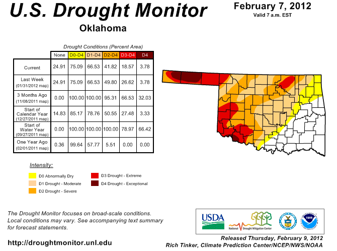
Is it the end of drought? No, but it's a great step for those areas in that part
of the state that continued to miss the big rainfalls. Now we need to spread that
to the northwest and south.
******************************************************************************
Our old "friend" La Nina fading away
I almost hate to see it go since it has been somewhat kind to Oklahoma this
go around. The previously mentioned parts of the state would not agree, but
the amount of rainfall under this La Nina event for much of the state has been
nothing short of miraculous. I had been spreading the news early last fall that
normal precipitation amounts were not going to be enough to bring us out of
drought. Lo and behold, the atmosphere came through in the clutch.

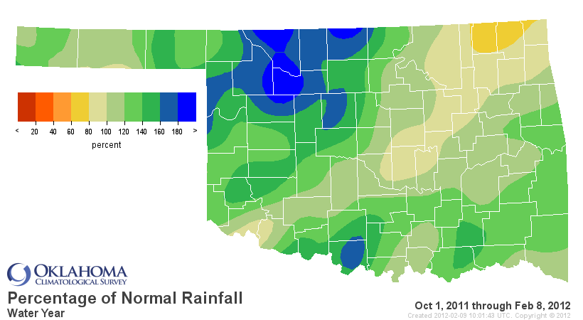
That's the key to understanding these large-scale climate influences, like
ENSO (El Nino/Southern Oscillation) or the Arctic Oscillation (AO) ... they
are meant to be guides at best. Not all act the same, just like "normal"
October precipitation totals at any particular location are made up of a wide
range of amounts. When all the factors came together, lots of rain in parts of
the Southern Plains was the result.
Regardless of its influence, La Nina is definitely on its way out. The National
Weather Service's Climate Prediction Center released its latest ENSO Diagnostic
Discussion this morning and pronounced La Nina to be near death.
"A majority of models predict La Ni?a to weaken through the rest of the
Northern Hemisphere winter 2011-12, and then to dissipate during the
spring 2012 ... Therefore La Ni?a is likely to transition to
ENSO-neutral conditions during March-May 2012."
Here you can see the model predictions for ENSO, with that reduction of the
sea surface temperature anomaly over the next couple of three-month periods.
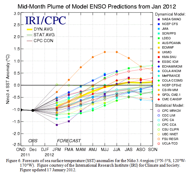
Now most of the models keep the anomaly in ENSO-neutral range into next fall.
A few of the models indicate a return to El Nino territory (anomaly greater
than 0.5C degrees) into the fall. There are a couple of caveats to these
outlooks that you absorb when you listen to the ENSO experts long enough.
1) There is no skill in statistical or dynamic model forecasts of long-range
ENSO this early.
2) February through may is a well-known and well-understood blackout or frailty
period of the forecasts.
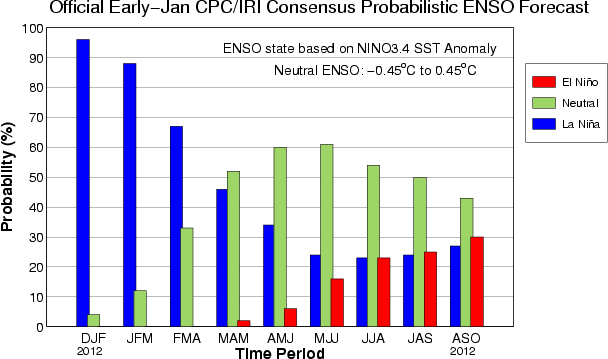
Here you can see the best available information, as gleamed from those model
forecasts, in the form of a graph and a table. The time periods are three-month
overlaps (e.g., MAM = March/April/May).
-****-
Season La Ni?a Neutral El Ni?o
DJF 2012 96% 4% 0.1%
JFM 2012 88% 12% 0.2%
FMA 2012 67% 33% 0.4%
MAM 2012 46% 52% 2%
AMJ 2012 34% 60% 6%
MJJ 2012 24% 61% 16%
JJA 2012 23% 54% 23%
JAS 2012 24% 50% 25%
ASO 2012 27% 43% 30%
-***-
So from the model forecasts, ENSO-Neutral is the most likely state going into
the next cool season. In reality, all you see there is the flattening out of
any particular forecast, with all three probabilities approaching 33%.
Now here's another kicker. When I solicited input from some of the country's
ENSO experts, they had some very interesting tidbits. Of the last 10 double-dip
La Ninas, four were followed by another La Nina and six were followed by El
Nino. One expert even said that ENSO-Neutral would be the most shocking result
next winter, at least using analogs.
Now let me run all of that through my "Okie from the Panhandle" translator for
you: Wait until June when the ENSO forecast skill increases to more trustworthy
levels. And remember, whether the forecast is for La Nina, ENSO-Neutral or El
Nino, it should be used as a guide only. An influencing factor, if you will.
"Usually" is a much nicer phrase than "supposed to."
Or "fixing to" for us Okies.
Gary McManus
Associate State Climatologist
Oklahoma Climatological Survey
(405) 325-2253
gmcmanus@mesonet.org
February 9 in Mesonet History
| Record | Value | Station | Year |
|---|---|---|---|
| Maximum Temperature | 82°F | GRA2 | 2000 |
| Minimum Temperature | -18°F | MEDF | 2011 |
| Maximum Rainfall | 1.02″ | VINI | 2001 |
Mesonet records begin in 1994.
Search by Date
If you're a bit off, don't worry, because just like horseshoes, “almost” counts on the Ticker website!