Ticker for February 1, 2012
MESONET TICKER ... MESONET TICKER ... MESONET TICKER ... MESONET TICKER ...
February 1, 2012 February 1, 2012 February 1, 2012 February 1, 2012
January Sees Warm Winter Continue for Oklahoma
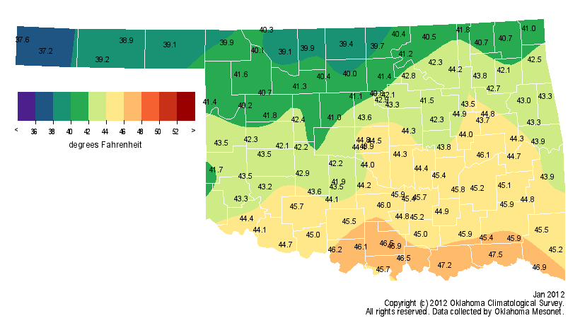
Snow was mostly a no-show during January as Oklahoma?s mild winter weather
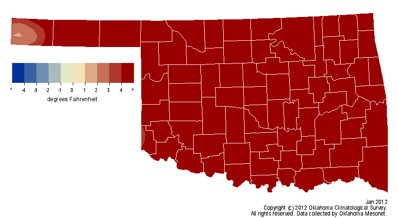
continued for a second month. The average temperature across the state soared to
nearly 7 degrees above normal to rank as the eighth warmest January since records
began in 1895. Combine that with a mild December and the first two months of the
winter season finished at more than 3 degrees above normal and ranked as the 16th
warmest such period on record. That story is not confined to Oklahoma. Much of
the United States has experienced an extremely mild winter thus far, accompanied
by a remarkable lack of snowfall. Temperatures in the Northern Plains states of
the Dakotas and Minnesota were 8-11 degrees above normal during January. By
January 31, only 19 percent of the United States was covered by snow. In
Oklahoma, only a few localized areas in central and northeastern parts of the
state reported snowfall totals of more than an inch for the month. The blizzard
that struck the Panhandle in mid-December remains the only significant snowstorm
to strike the state this season.
OK January Temperatures
US Snow Depth: 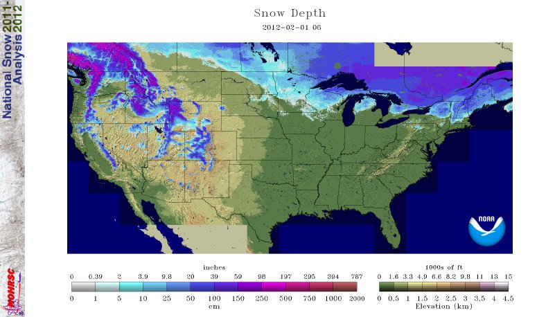
US Jan. Temps: 
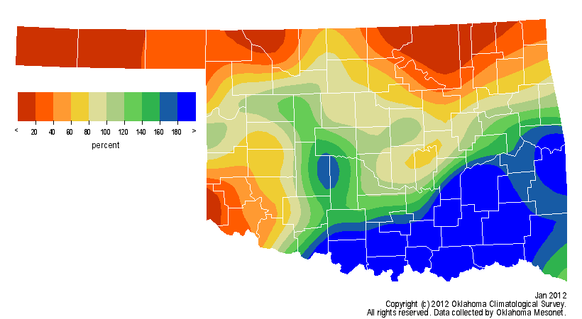
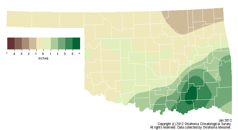
While the snowflakes were few and far between in January, there was plentiful,
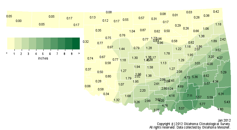
drought-quenching rainfall to be had for parts of the state. Southeastern and
south central Oklahoma saw totals range from 4-7 inches according to data from
the Oklahoma Mesonet. South central?s average total of 3.62 inches ranked as
the ninth wettest January for that area since 1895. Those generous totals were
enough to propel the statewide average rainfall during January to more than a
quarter of an inch above normal and a ranking of 38th wettest. Other parts of
the state were not so fortunate. Much of western and northern Oklahoma totaled
less than half of an inch of precipitation. The Mesonet site at Boise City
received no measurable precipitation for the month and Copan barely wet the
gauge with a hundredth of an inch. Northeastern Oklahoma?s average January
total of a little more than a half of an inch was the 15th lowest on record
while the Panhandle averaged just over a tenth of an inch. The Mesonet site at
Lane led the state with 7.11 inches of rainfall. Tulsa?s total of 0.61 inches
was 1.05 inches below normal and Oklahoma City was nearly an inch above normal
with a total of 2.23 inches.
OK January Precipitation
Drought was eliminated in the southeastern quarter of the state thanks to
abundant rainfall since last October. Rainfall totals of 15-25 inches were
recorded since October 1, 2011, in south central and southeastern Oklahoma.
Unfortunately, much of western and northern Oklahoma remains in severe to
extreme drought according to the latest Drought Monitor report. In those areas,
precipitation amounts of less than 10 inches ? and in some cases less than 5
inches ? have made small strides against the dry weather, but long-term
deficits of more than 15 inches since the beginning of the drought continue to
dominate. Many farm ponds remain extremely low or completely dry. Levels at
some state reservoirs were also quite low. Skiatook Lake in northeastern
Oklahoma was at 62 percent of capacity as of January 31 and Canton Lake in the
northwest was at 29 percent of capacity. The low level at Lake Altus in the
southwest remains a concern for area cotton farmers. The lake, which is at 18
percent capacity, is vital to the area?s cotton growers due to its use as an
irrigation source. Significant recharge will need to occur throughout spring
for use by cotton growers.
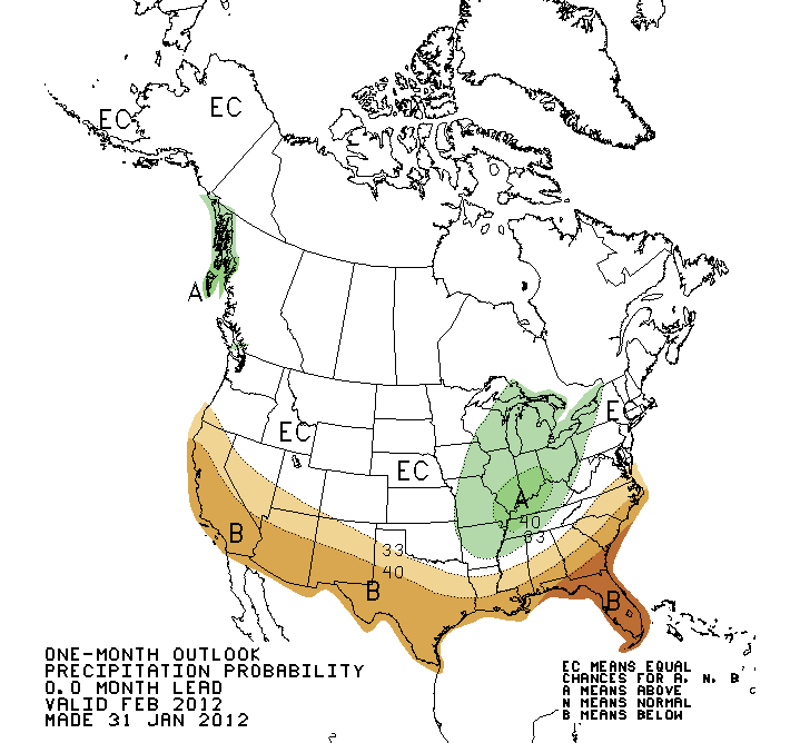
The latest February outlooks from the National Weather Service?s Climate
Prediction Center are noncommittal for precipitation over Oklahoma. In their
view, there is an equal chance of above-, below- or near-normal precipitation
for the month. On the temperature side, they are seeing increased odds of above
normal temperatures to end the winter season. Should that occur, the concern
for Oklahoma?s vegetation could increase. Early and continuous warmth can bring
plants out of dormancy earlier, leaving them more vulnerable to late-freeze
events similar to what the state experienced in 2007 and 2009.
February CPC Outlooks

Gary McManus
Associate State Climatologist
Oklahoma Climatological Survey
gmcmanus@mesonet.org
(405) 325-2253
February 1 in Mesonet History
| Record | Value | Station | Year |
|---|---|---|---|
| Maximum Temperature | 81°F | SLAP | 2003 |
| Minimum Temperature | -7°F | BOIS | 2011 |
| Maximum Rainfall | 1.61″ | MTHE | 2011 |
Mesonet records begin in 1994.
Search by Date
If you're a bit off, don't worry, because just like horseshoes, “almost” counts on the Ticker website!