Ticker for January 31, 2012
MESONET TICKER ... MESONET TICKER ... MESONET TICKER ... MESONET TICKER ...
January 31, 2012   January 31, 2012   January 31, 2012   January 31, 2012


A sneak peak at the January 2012 temperature statistics

There are a few things I have learned by observation. One is to not walk up a
muddy hill carrying a six pack of cokes in each hand. Another is to never turn
around and talk to somebody while walking by telephone poles. One more is to
never count the last day of a month out in its ability to mess up your statistics.
So as you read these facts and tidbits about this January's weather, keep in mind
we have one more unusually warm day to go.

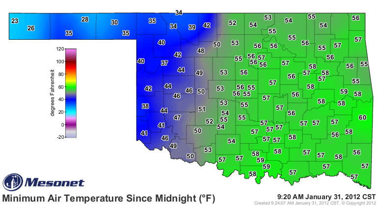
To begin, how unusually warm will January 31, 2012, be? Well, it's already off
to a good start. Check out this morning's low temperatures from the Oklahoma
Mesonet and compare those to the record warm minimum temperatures for that date
in Oklahoma history.

Records:
This morning:

As you can see, we had a large number of stations across the eastern two-thirds
of the state near or exceed their previous high minimum temperature records.
Oklahoma City's record high minimum temperature for January 31 is 52 degrees,
set way back in 1911. The low thus far today has been 55 degrees, so that would
have set a record. The problem there (and with the other hourly stations that
take their observations from midnight to midnight) is that a cold front will be
moving through later today and we'll probably see the thermometer back below
those record numbers by midnight. For those stations that take their low
temperature reading for the day at 6 a.m. or some other time, those records will
probably stand (don't get me started).

Here are the January 2012 temperature stats for the nine different climate
divisions in Oklahoma, as well as the statewide averages. I've thrown January
2011 averages on there for comparison.

-****-
Clim Div	Avg Temp    Dep from Norm    Rank since 1895	Jan-11
Panhandle	  39.0	         6.0	       8th Warmest	 32.5
North Central	  40.3	         6.8	      11th Warmest	 32.0
Northeast	  42.5	         7.9	       6th Warmest	 33.5
West Central	  42.2	         7.2	      10th Warmest	 34.8
Central           43.3	         7.1	       8th Warmest	 35.2
East Central	  44.4	         7.1	       9th Warmest	 36.0
Southwest	  43.9	         6.4	       9th Warmest	 36.4
South Central	  45.8	         6.7	       9th Warmest	 37.2
Southeast	  45.6	         6.0	      10th Warmest	 35.7
Statewide	  42.9	         6.8	       8th Warmest	 34.8
-***-

So about 7 degrees above normal. And about 6-9 degrees warmer than last January!
Remember that on January 31 last year, the blizzard was about to hit the fan.
And Mother Nature didn't clean that mess up until mid-February.

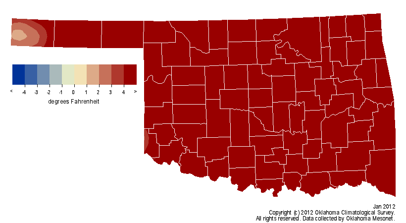
Here we can see those temperatures in pictures. It was so warm it blew right
off the scale in the departure from average map.


The highest temperature recorded this month was the 79 at Mangum on the 16th and
the lowest was 9 degrees at Nowata on the 18th.

Here are the numbers for winter thus far (Dec 2011-Jan 2012).

-****-
Clim Div	Avg Temp	Departure	Rank
Panhandle	  35.0	           1.0	    49th Warmest
North Central	  38.8	           3.8	    13th Warmest
Northeast	  40.5	           4.1	    13th Warmest
West Central	  40.5	           4.3	    10th Warmest
Central	          41.6	           3.8	    12th Warmest
East Central	  43.0	           4.0	    14th Warmest
Southwest	  41.7	           3.1	    21st Warmest
South Central	  43.8	           3.2	    20th Warmest
Southeast	  44.6	           3.6	    13th Warmest
Statewide	  41.0	           3.4	    16th Warmest
-***-

So not the warmest first two months of winter, but it's nothing to sneeze at
either. The only thing that stopped it from moving up the ranks was
that massive blizzard in mid-December out in the Panhandle. That snowpack kept
that area well below normal for the second half of December and brought the
statewide average down a few notches.

Finally, there are still quite a few stations in southeastern Oklahoma that
have yet to see a day where the high temperature remains below freezing, and
many more that have only seen one day.


Will the warm weather continue into February? The latest outlooks for next
month should be out later today. Hopefully they'll give us a clue as to what
we can expect for February.

By the way, I was not the recipient of the face full of mud or telephone pole
I talked about in my first paragraph. Having the last day of the month spoil
my carefully laid out statistics? Guilty.

Check back tomorrow.

Gary McManus
Associate State Climatologist
Oklahoma Climatological Survey
(405) 325-2253
gmcmanus@mesonet.org
January 31 in Mesonet History
| Record | Value | Station | Year |
|---|---|---|---|
| Maximum Temperature | 80°F | WAUR | 2018 |
| Minimum Temperature | 2°F | EVAX | 2023 |
| Maximum Rainfall | 3.45″ | CLOU | 2002 |
Mesonet records begin in 1994.
Search by Date
If you're a bit off, don't worry, because just like horseshoes, “almost” counts on the Ticker website!