Ticker for October 20, 2011
MESONET TICKER ... MESONET TICKER ... MESONET TICKER ... MESONET TICKER ...
October 20, 2011 October 20, 2011 October 20, 2011 October 20, 2011
Drought intensifies in eastern Oklahoma, CPC releases bleak winter outlook
There is a lot of information contained in this Ticker, and little of it good.
If you want to save it for Halloween night to scare the kids, feel free.
As has been the case throughout 2011, one part of the state receives a decent
rainfall but other areas of Oklahoma spend weeks with little relief. That
pattern continued as northeastern Oklahoma missed out on the beneficial rains
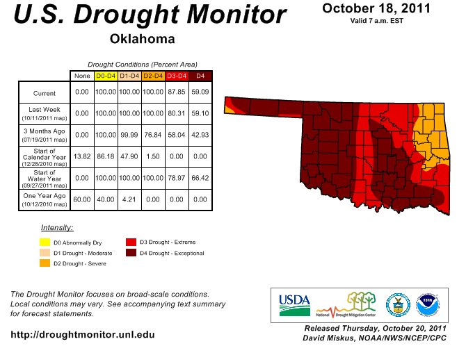
of two weeks ago. The newest U.S. Drought Monitor map reflects growing concerns
over reservoir levels in eastern Oklahoma with an increase in coverage of D3 or
"extreme" drought. The coverage of D3-D4 drought increased from 80 percent
last week to 87 percent across the state. All of the state is covered by
severe-to-exceptional (D2-D4) drought.
The little bit of rain that fell with the cold front earlier this week was not
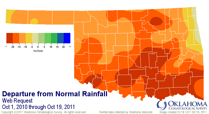
enough to generate improvement in the drought picture in southeastern Oklahoma
where deficits are on the order of 20-25 inches since last October. The rainfall
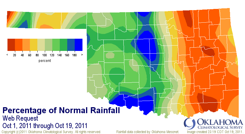
pattern for the month thus far is opposite of what we've seen for much of 2011
- above normal moisture in the western half of the state and below normal in
the eastern half. Overall, the statewide average rainfall total through
October 19 is 1.81 inches, about a quarter of an inch below normal. Deficits
are between 1.5-2.5 inches in eastern Oklahoma, however.
2011 is shaping up to be one of the state's driest on record, and is actually
threatening the all-time driest year of 19.04" in 1910. The statewide average
total stands at 17.71 inches through the 19th, 12.72 inches below normal.
The Oklahoma Mesonet site at Hooker has only recorded 3.7 inches of
precipitation this year, threatening the all-time lowest annual total for a
single location of 6.53 inches recorded at the Cimarron County town of Regnier
in 1956. Plenty of time remains to avoid those records during 2011, although
the state's driest time of the year is quickly approaching. Normal rainfall
for the remainder of the year is approximately 5 inches.
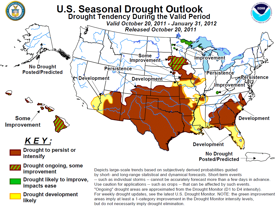
The latest U.S. Seasonal Drought Outlook from the NWS' Climate Prediction
Center (CPC) gives little hope for improvement in the Southern Plains drought
conditions at least through January 31st. Oklahoma remains firmly ensconced
in the "drought to persist or intensify" area thanks to the strengthening La
Nina in the equatorial pacific waters.
Quoting the CPC directly ("HIGH CONFIDENCE FORECAST"):
"Across the southern tier of states and in the central Plains, drought
is expected to persist and expand into adjacent areas. Except for
wetness being favored in Colorado and northern New Mexico for the
6-10 day period, all tools are in remarkable concert, pointing toward
drier than normal conditions. Thus, this is a high confidence forecast."
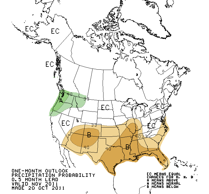
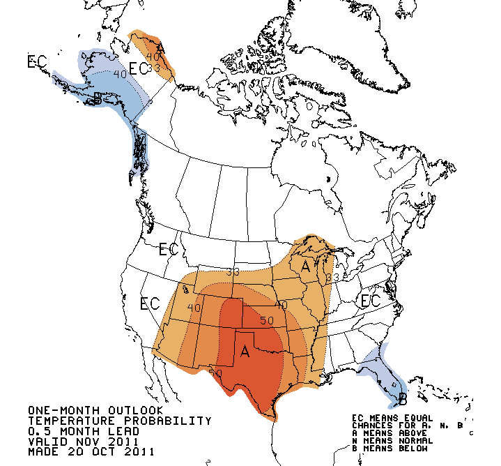
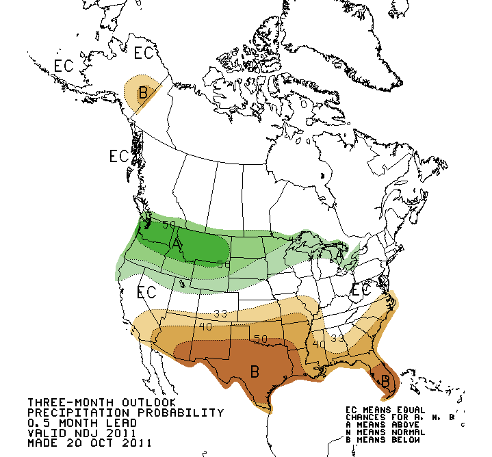
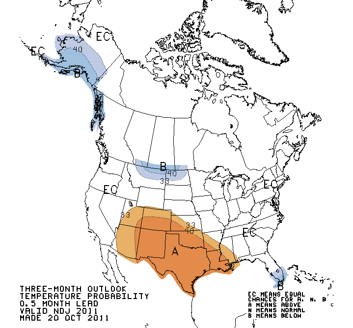
The outlooks for November/November-January/December-February are all dominated
by the classic La Nina signal, and hold little good news for Oklahoma and the
Southern Plains. These are probability maps and indicate increased chances for
below normal precipitation and above normal temperatures. No information is
contained in them about the magnitude of the precipitation deficits or
temperature anomalies.
November Outlooks
November-January Outlooks
Winter Outlooks (December-February)
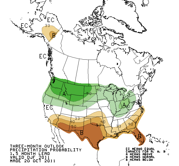
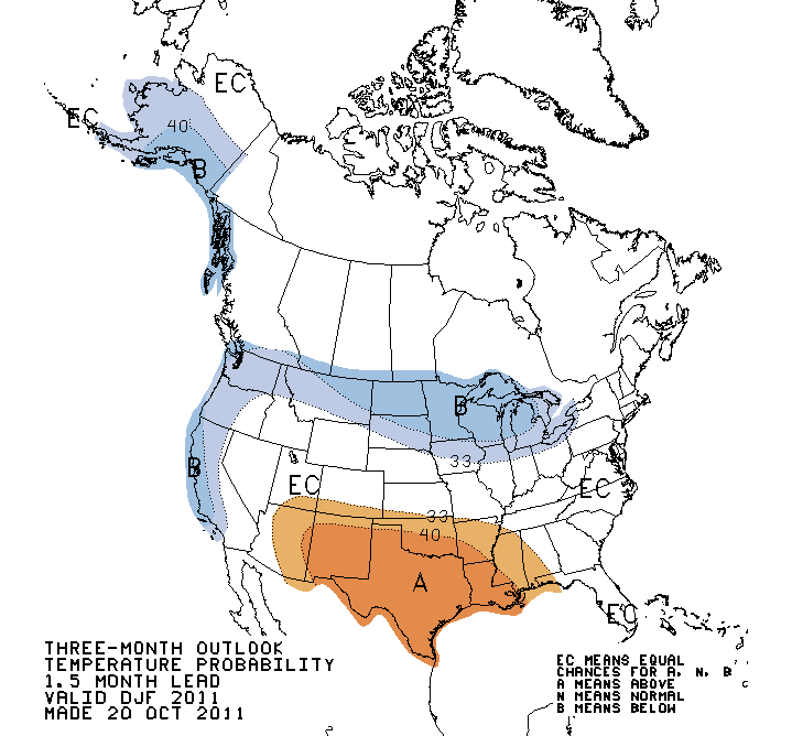
The three-month outlooks that blend into spring have similar patterns for both
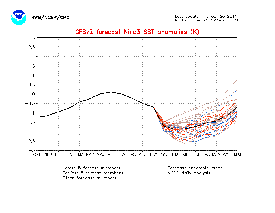
temperature and precipitation. The sea surface temperature models used by the
CPC indicate this La Nina could become as strong or even exceed the strength of
last winter's event with three-month anomalies approaching -2 degrees Celsius.
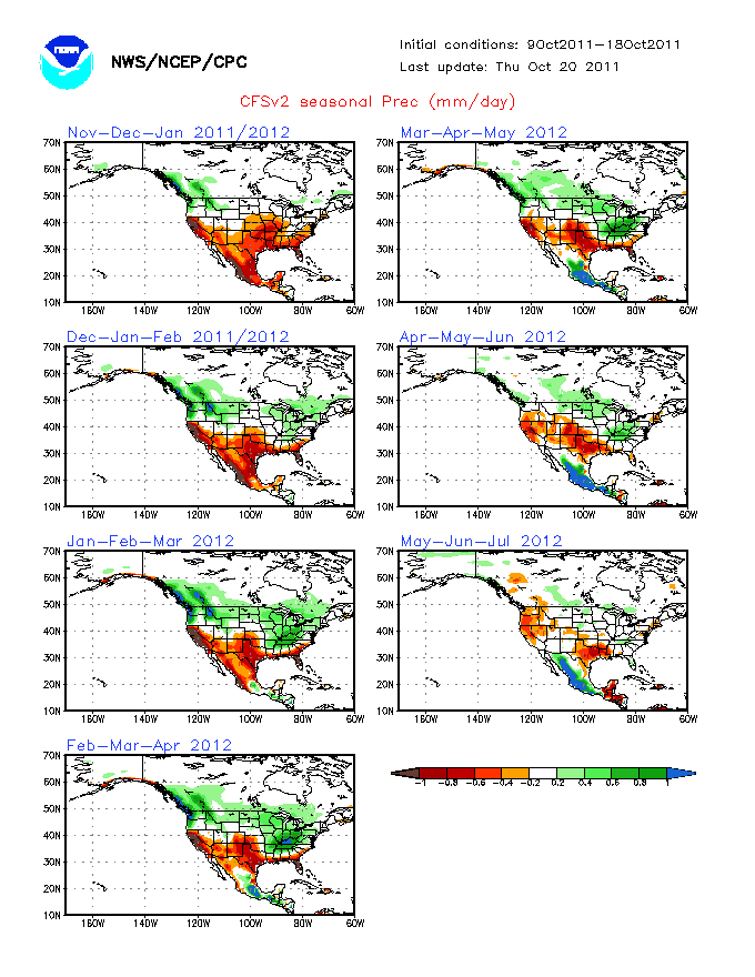
The resultant precipitation forecasts from those same models tell the story
in pictures with precipitation deficits continuing through next spring for the
western half of the state.
As I said at the top, there is little good news in this information, especially
for Oklahoma agriculture. However, all hope is not lost. Here are some important
caveats.
1) We should not necessarily expect the extreme deficits of the last year.
Those were "extreme" extremes, and don't come around very often (and they were
certainly not forecast).
2) Outlooks are not infallible, nor do La Nina impacts always follow the script.
3) A few well-placed precipitation events can keep the current wheat crop going
through the worst of what Mother Nature has to offer. If there is one thing
Oklahoma agricultural producers know, it's not always the amount of
precipitation that is most important. Timing is everything.
4) No information is contained within these outlooks or forecasts about extreme
snow or ice events, although the dry signal would indicate less precipitation
of any form. Remember, Oklahoma set its all-time 24-hour snowfall record last
February with 27 inches at Spavinaw and the first half of that month was
basically one big blizzard. The state's all-time record low temperature of -31
degrees was reached at Nowata last February 10.
5) Many eservoir levels are very low going into our driest time of the year.
That will become a greater concern should the precipitation deficits continue
into the warm months. Water usage bottoms out during the winter months so any
precipitation that does fall is very important for recharge. The same goes for
soil moisture.
We will continue to monitor the latest from the CPC and other governmental
agencies to keep you informed as best as possible. Hopefully there will be
better news as we go through the next several months.
We're Okies ... we've been through worse.
Gary McManus
Associate State Climatologist
Oklahoma Climatological Survey
(405) 325-2253
gmcmanus@mesonet.org
October 20 in Mesonet History
| Record | Value | Station | Year |
|---|---|---|---|
| Maximum Temperature | 96°F | CAMA | 2003 |
| Minimum Temperature | 23°F | NOWA | 2011 |
| Maximum Rainfall | 3.10 inches | LANE | 1996 |
Mesonet records begin in 1994.
Search by Date
If you're a bit off, don't worry, because just like horseshoes, “almost” counts on the Ticker website!