Ticker for October 6, 2011
MESONET TICKER ... MESONET TICKER ... MESONET TICKER ... MESONET TICKER ...
October 6, 2011 October 6, 2011 October 6, 2011 October 6, 2011
The Drought before the storm
We've all heard by now that rain is possible this weekend. News of this sort has
become oddly paramount when it used to be oddly ordinary. Probably a result of
how infrequent these rainfall events have become. If you can recall, our last
widespread event was three weeks ago from on September 16-18. And the one before
that was on August 10-13. The one previous to that was ... well, let's go with
June 10-12. Throughout those events, western Oklahoma has been left largely high
and dry. This next event looks like a decent soaker for the western third of the
state and the Panhandle. How much that translates into central and eastern
Oklahoma is up for debate in the computer models. For a fantasy-cast, here's the
5-day precipitation totals from the HPC good for this morning through Tuesday
morning.
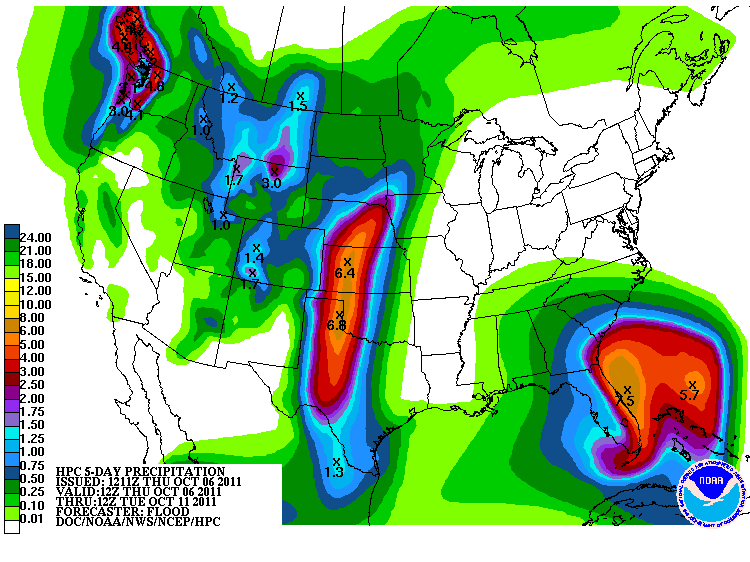
I think 6.8 inches west of Cheyenne might be pushing it, but let's hope for a
couple-three inches at least. The rest is gravy. A very muddy gravy, but gravy
nonetheless.
Where are we starting? Well, much the same place we've been at for the last
several months. Simply put, the western half of the state has experienced its
driest water year on record, carrying out into the beginning of this new water
year. And it's not even close, topping the previous driest water year by
several inches. Reminder, the water year runs from Oct 1-Sep 30.
So this:
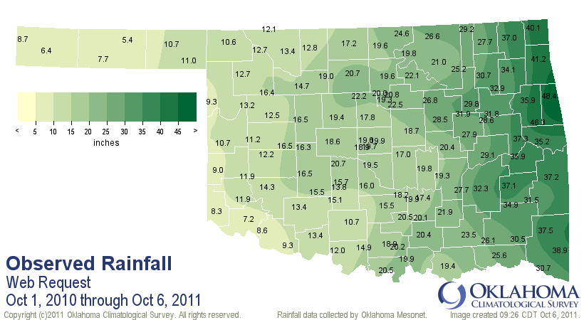
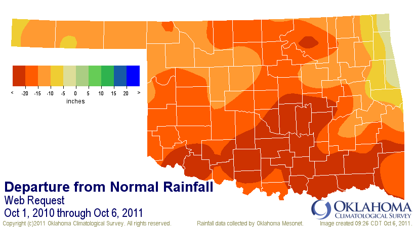
and this:
Oklahoma Rainfall Statistics (Oct. 1, 2010-Oct. 6, 2011)
Climate Div. Total Dep. Pct. Rank Prev. Driest
Panhandle 8.72" -12.56" 41% 1st driest 11.35" (1955-56)
N. Central 16.59" -15.88" 51% 2nd driest 15.00" (1955-56)
Northeast 29.95" -13.59" 69% 9th driest 21.62" (1955-56)
W. Central 12.64" -17.02" 43% 1st driest 15.87" (1955-56)
Central 19.59" -18.42" 52% 1st driest 19.66" (1955-56)
E. Central 33.52" -13.46" 71% 10th driest 22.52" (1955-56)
Southwest 12.26" -19.08" 39% 1st driest 16.91" (1955-56)
S. Central 18.46" -21.98" 46% 2nd driest 15.97" (1955-56)
Southeast 33.01" -18.75" 64% 3rd driest 25.67" (1955-56)
Statewide 20.44" -16.76" 55% 2nd driest 18.20" (1955-56)
begets this, the latest U.S. Drought Monitor map, fresh off the presses:
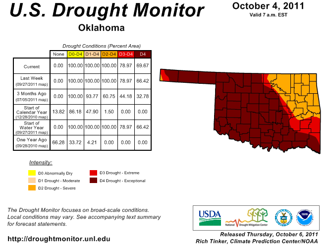
The changes were slight, a 3% increase in D4 in southeastern Oklahoma. Notice
the bottom line on the table in the figure where we were last year at this time
with only 4% of the state in a drought designation (and D1 at that).
The latest Seasonal Drought Outlook contains some fair/good news for western
Oklahoma with an area of "drought ongoing, some improvement" noted from I-35
westward through most of the Panhandle.
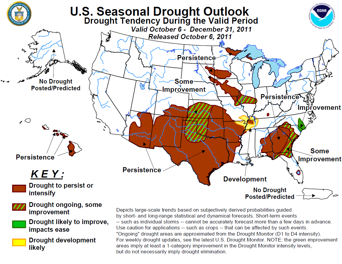
I can tell you from discussions with the CPC forecasting team that the
improvement area is due mainly to this upcoming rainfall event. Quoting the
CPC folks:
"A large area of extreme to exceptional drought continues across the
southern Plains where below normal precipitation has persisted since
mid-September. During the second week of October, an upper-level
trough is expected to bring much needed rainfall to western Oklahoma,
the Texas Panhandle, and northwest Texas. The potential exists for 1
to 3 inches of rainfall, with locally higher amounts, where some
improvement is forecast. Across the remainder of Oklahoma and Texas
persistence is based on the OND precipitation outlook calling for
enhanced odds of below median precipitation."
Note that this outlook pertains to the remainder of the year through December
31, so this outlook is definitely weighted towards the next few days. They
decided against the all-green "Drought likely to improve, impacts ease" just
yet since the rains are falling in places where the deficits are 15-25" over
the last year.
Regardless, any rain that does fall will be very much welcomed, especially by
the winter wheat crop waiting for moisture so planting can occur, or the crop
that's been dusted in and now needs moisture. If you will recall, timely rains
in western Oklahoma allowed for planting in October and even a late-planting
in November last year.
October 2010: 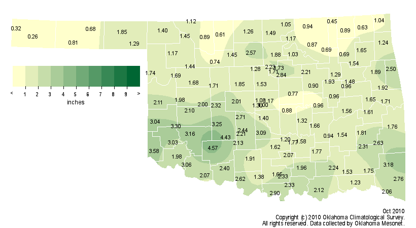
November 2010: 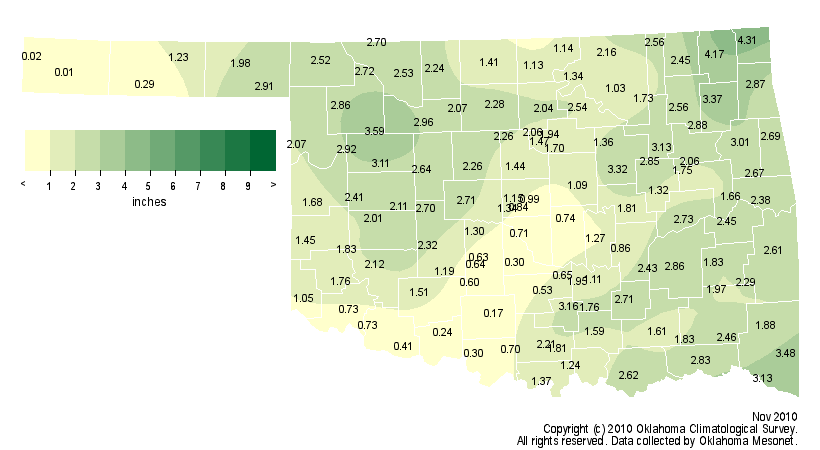
Once this chance is gone, it might be awhile if things continue working the
way they have.
CPC outlooks for October 11-19:
6-10 day precip: 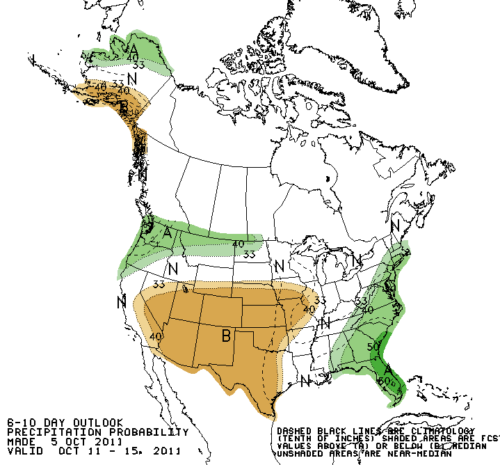
6-10 day temps: 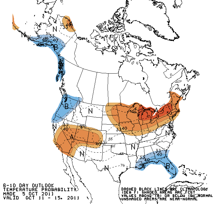
8-14 day precip: 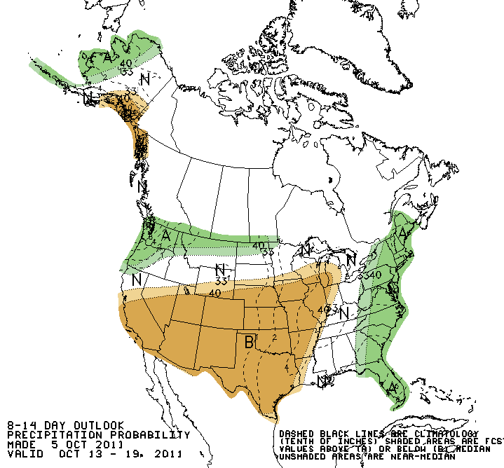
8-14 day temps: 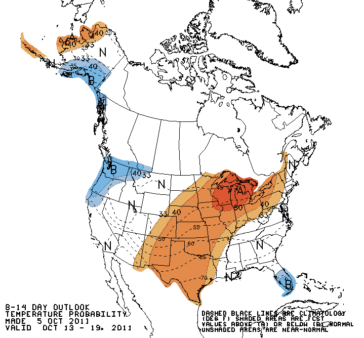
As usual, I'm loving this rain, but hoping for less of a wait on the next.
Gary McManus
Associate State Climatologist
Oklahoma Climatological Survey
(405) 325-2253
gmcmanus@mesonet.org
October 6 in Mesonet History
| Record | Value | Station | Year |
|---|---|---|---|
| Maximum Temperature | 95°F | FREE | 2016 |
| Minimum Temperature | 27°F | KENT | 2013 |
| Maximum Rainfall | 7.75 inches | JAYX | 2019 |
Mesonet records begin in 1994.
Search by Date
If you're a bit off, don't worry, because just like horseshoes, “almost” counts on the Ticker website!