Ticker for September 16, 2011
MESONET TICKER ... MESONET TICKER ... MESONET TICKER ... MESONET TICKER ...
September 16, 2011 September 16, 2011 September 16, 2011 September 16, 2011


Rain scattered thus far, but welcomed

There's probably yet another hair joke in that title somewhere, but I've just
about run out. Of hair. Sorry, couldn't resist.

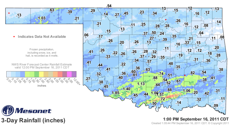
The rainfall through 12:30pm or so the last couple of days, including a radar-
estimated deluge of up to 5 inches in a narrow band in south central Oklahoma.


The rest of the state? Welllll, not so much. A widespread area of about an inch
a little farther to the north than that narrow band, and between 1-2 inches in
parts of Tillman and Cotton counties. And let's not forget Goodwell in the
Panhandle with an inch as well. So congrats to those that have received the
rainfall thus far, and more is promised over the next few days.

The 1.85 inches at Grandfield from September 14th through today matches their
rainfall total over the last 117 days, dating back to May 20th. It raises their
total since October 1, 2010, from 5.9 inches to 7.8 inches. I'm betting there
are folks down there looking for the nearest ark-building company. Let's hope
more is on the way.

The rain did raise the statewide average by a few tenths, from 14.16 inches
last week to 14.71 inches through 1 p.m. or so.

Remember, rain falling in this type of weather will be very beneficial since
it won't be followed up by triple-digit temperatures. The gray skies are a great
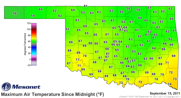
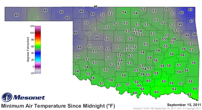
help. Yesterday was very cool across the state with low temperatures in the
40s and 50s and highs mostly in the 60s.


Thanks to the front and the rain, those lows mostly occurred during the day
while those highs occurred in the wee hours on the morning. With a statewide
average of 58.5 degrees (highs and lows averaged together), yesterday was the
coolest day in the state since May 16th's 57.4 degrees. For reference, August
2nd was the warmest day this year at 94.5 degrees and February 2nd was the
coldest at 9.7 degrees.

Gary McManus
Associate State Climatologist
Oklahoma Climatological Survey
(405) 325-2253
gmcmanus@mesonet.org
September 16 in Mesonet History
| Record | Value | Station | Year |
|---|---|---|---|
| Maximum Temperature | 102°F | WALT | 1997 |
| Minimum Temperature | 37°F | KENT | 2012 |
| Maximum Rainfall | 3.52 inches | BURB | 2013 |
Mesonet records begin in 1994.
Search by Date
If you're a bit off, don't worry, because just like horseshoes, “almost” counts on the Ticker website!