Ticker for April 15, 2011
MESONET TICKER ... MESONET TICKER ... MESONET TICKER ... MESONET TICKER ...
April 15, 2011 April 15, 2011 April 15, 2011 April 15, 2011
Rain for some, wind for all
A few parts of eastern Oklahoma received heavy rainfall from last night's
destructive storms.
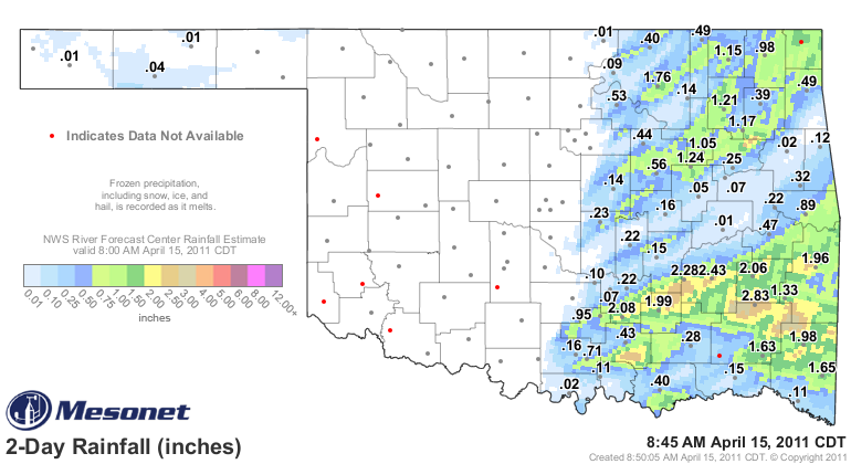
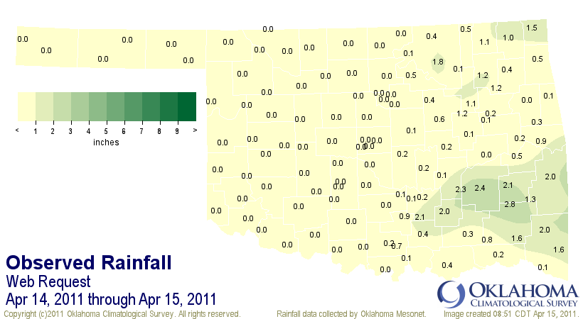
The Oklahoma Mesonet gauges and the River Forecast Center radar estimate overlay
show 1-3 inches of rain over the southeastern quarter. Here are the Mesonet
rainfall totals of at least an inch from last night.
Clayton 2.83 Broken Bow 1.65
McAlester 2.43 Cloudy 1.63
Stuart 2.28 Miami 1.54
Fittstown 2.08 Talihina 1.33
Wilburton 2.06 Hectorville 1.24
Centrahoma 1.99 Claremore 1.21
Mt Herman 1.98 Inola 1.17
Wister 1.96 Nowata 1.15
Wynona 1.76 Bixby 1.05
Robust totals for some, but 83 of the 120 Mesonet stations received less than a
quarter-inch of rain and 59 of those 83 received nothing at all. Little solace
will be found in those beneficial rains considering the terrible price paid by
some of the folks in the eastern half of the state.
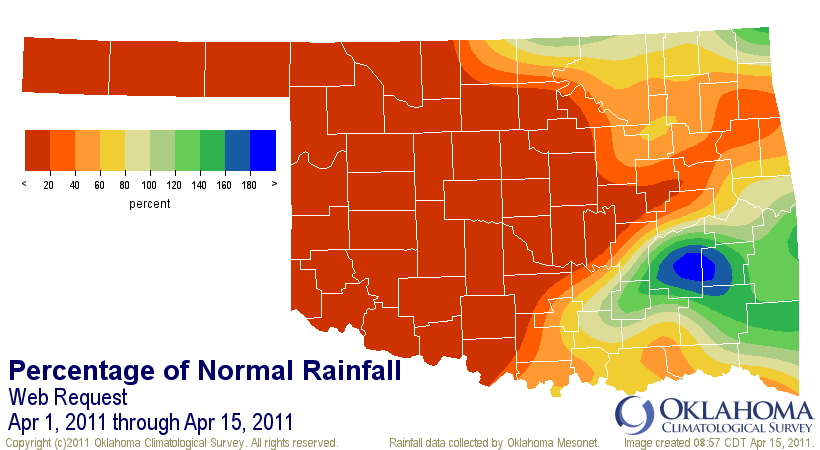
At least for April, areas surrounding Pittsburg and Latimer counties are ahead
of the curve for April rainfall. Most of the western half of the state is one
huge void of moisture according the this map, however.
*************************************
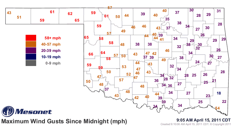
High winds are now the focus as seen in these two Mesonet maps - maximum wind
gusts in the last hour and since midnight. Gusts from 40-60 mph are prevalent
throughout the western half of the state.
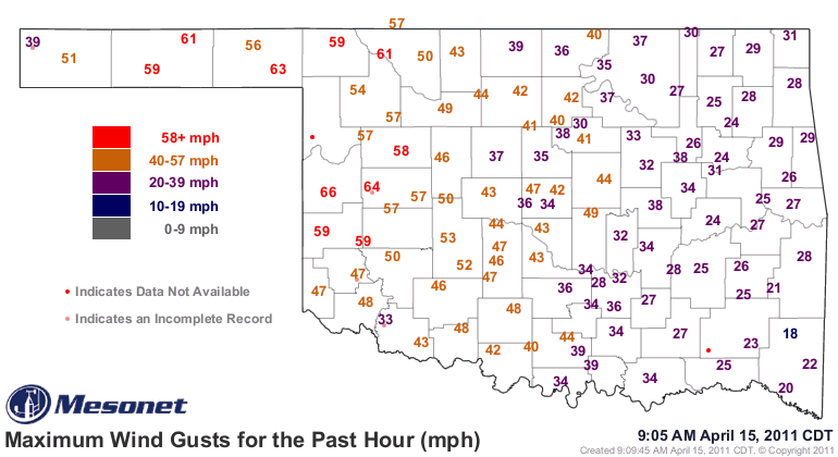
The gusts from yesterday reflect the high winds associated with the severe
weather in eastern Oklahoma.
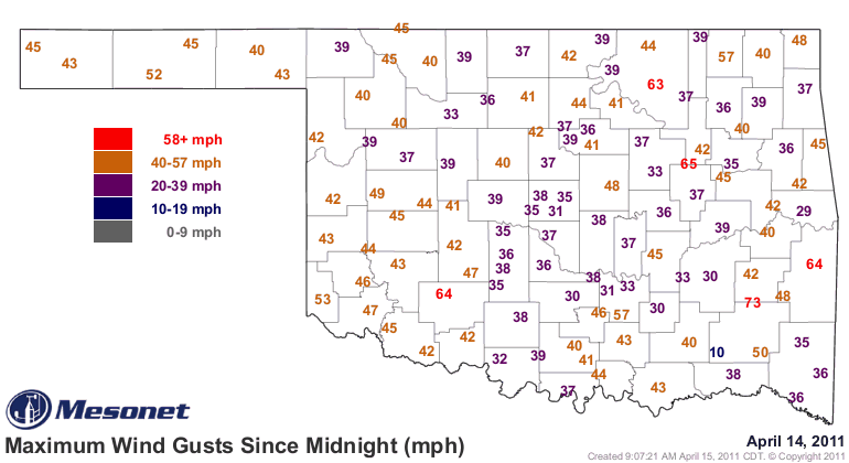
In just the last hour alone there have been 38 wind gusts of at least 58 mph
(NWS severe levels) and 86 in the last 24 hours. Here is the top 10 highest
wind gusts, a mixture of thunderstorm and non-thunderstorm related reports:
Clayton 73 mph Apr 14 09:35 PM
Clayton 69 mph Apr 14 09:40 PM
Cheyenne 66 mph Apr 15 08:50 AM
Cheyenne 66 mph Apr 15 08:20 AM
Arnett 65 mph Apr 15 06:15 AM
Slapout 65 mph Apr 15 05:50 AM
Hectorville 65 mph Apr 14 09:25 PM
Butler 64 mph Apr 15 09:05 AM
Slapout 64 mph Apr 15 07:50 AM
Medicine Park 64 mph Apr 14 10:35 PM
*****************************************
Finally, a bit of an oddity was spotted by a couple of Mesonet folks last night,
Student Operator Zach Elliott and Lead Operator Cindy Morgan. Check out the
Mesonet meteogram from yesterday through today, specifically the dewpoint
temperature.
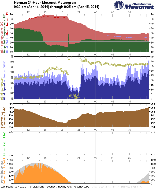
Zach and Cindy did such a great job spotting and diagnosing it I'll let their
words tell the story. Zach's description of the dewpoint spike around 7 p.m.:
"... at 7pm the Dewpoint went from 19.4 at 7, 33.5 at 7:05, and 48.2 at 7:10
and then 29.7 at 7:15 where it leveled out."
Cindy diagnosed the spike using radar:
"If you pull up the enhanced base reflectivity (tilt 1), you'll see that the
dry line retreats just a little bit as the cold front approaches (both show up
as very faint lines). The dry line begins to retreat over Norman just as the
cold front hits NRMN, causing the increase in TDEW, then abrupt decrease."
Great find and detective work, guys!
Gary McManus
Associate State Climatologist
Oklahoma Climatological Survey
(405) 325-2253
gmcmanus@mesonet.org
April 15 in Mesonet History
| Record | Value | Station | Year |
|---|---|---|---|
| Maximum Temperature | 102°F | GRA2 | 2006 |
| Minimum Temperature | 19°F | KENT | 2020 |
| Maximum Rainfall | 3.01″ | BOIS | 2016 |
Mesonet records begin in 1994.
Search by Date
If you're a bit off, don't worry, because just like horseshoes, “almost” counts on the Ticker website!