Ticker for April 19, 2011
MESONET TICKER ... MESONET TICKER ... MESONET TICKER ... MESONET TICKER ...
April 19, 2011     April 19, 2011     April 19, 2011     April 19, 2011


Antlers Mesonet site moves

The Antlers Mesonet site has been a faithful sentinel in the southwest corner of
Pushmataha County for more than 17 years (by the way, try and Push My Ta Ha and
we'll have words!). Through that time, it has seen some of the best and worst
Oklahoma weather has to offer.  Site Extremes since commissioning on January 01,
1994 were:

Maximum air temperature (?F) 	110 	09/03/2000
Minimum air temperature (?F) 	1 	02/10/2011
Maximum daily rainfall (in.) 	6.03 	04/07/2002
Maximum monthly rainfall (in.) 	13.18 	11/1996
Maximum annual rainfall (in.) 	64.64 	1996
Maximum wind speed (mph) 	52.5 	06/13/2009

Over the last week or so, the hardest working folks in weather, the Oklahoma
Mesonet technicians, moved the Antlers site from its spot 5 miles west of town
to a new home 3 miles west northwest of town.

The particulars of the new station are:
ANT2 (replaces ANTL)
Commissioned on:  April 15, 2011 (00 UTC)
Location: 3 miles WNW of Antlers
Latitude: 34.249670
Longitude: -95.668440
Elevation: 172 meters AMSL

So to quote Officer John McClane from "Die Hard": Welcome to the party, ANT2!

***********************************

Since we have been getting the dust from three or four different states in our
mouths with each weather system that goes through, that prompted a few of us
around here to wonder "Am I in the Panhandle again?" No wait, that was just me.
But a few of us thought that it seemed a tad windier than what we were
accustomed to. Luckily, I have access to this handy-dandy contraption known as
"the Mesonet" so if I expend the effort, I can actually rank just how windy it
has been (at least through 1994).

I looked at the average wind speeds for each January 1-April 18 period back
through 1994 and it looks like my memory deceived me. Here are the rankings
of the 18 periods in miles per hour.

1996	10.92
2009	10.81
2008	10.63
2006	10.27
2002	10.22
1999	10.06
1994	9.96
2011	9.88
1998	9.61
1995	9.56
2007	9.54
2003	9.51
1997	9.42
2010	9.39
2000	9.39
2004	9.32
2005	9.05
2001	8.67

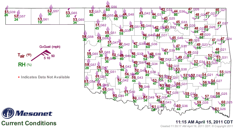
Of course, these rankings are of little solace when your fence just blew down
and the Mesonet maps have pennants (average wind speeds of at least 50 mph) on
them:


But that's okay, Memory does that to you. Sometimes it can even be useful. For
example, in my memory I still have a flowing head of hair!

Now, off to make fists with my toes.

Gary McManus
Associate State Climatologist
Oklahoma Climatological Survey
(405) 325-2253
gmcmanus@mesonet.org
April 19 in Mesonet History
| Record | Value | Station | Year |
|---|---|---|---|
| Maximum Temperature | 95°F | HOLL | 2023 |
| Minimum Temperature | 21°F | BOIS | 2013 |
| Maximum Rainfall | 4.77″ | NEWP | 2025 |
Mesonet records begin in 1994.
Search by Date
If you're a bit off, don't worry, because just like horseshoes, “almost” counts on the Ticker website!