Ticker for April 14, 2011
MESONET TICKER ... MESONET TICKER ... MESONET TICKER ... MESONET TICKER ...
April 14, 2011     April 14, 2011     April 14, 2011     April 14, 2011


Not about tornadoes!

Okay, the three of you left will enjoy this I hope. Since my previous Ticker
contained an unfortunate but completely understandable and forgivable (see what
I did there??) mistake, let's head back to something a bit more concrete ...
drought. And it is still apropos, since the western half of the state is going
to be dessicated today while eastern Oklahoma tries to avoid being decimated.

Never a dull moment in Oklahoma!

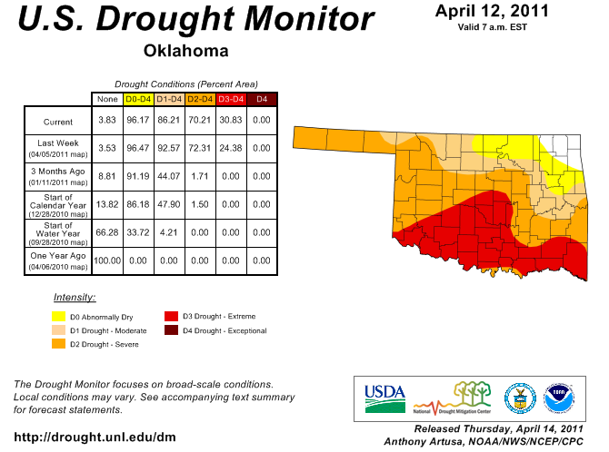
The new Drought Monitor map came out today and not many changes occurred. A bit
of expansion of D3 drought to the north and a lessening of drought in Grant, Kay
and Osage counties.


So the rain in north central Oklahoma at least put a dent in some of the impacts
for that area (i.e., the wheat received a nice big gulp of water). The 2"+
(2+"??) down in the southeast was not enough to move it down the Drought
Monitor scale. The trouble for the southeast is that the drought is occurring
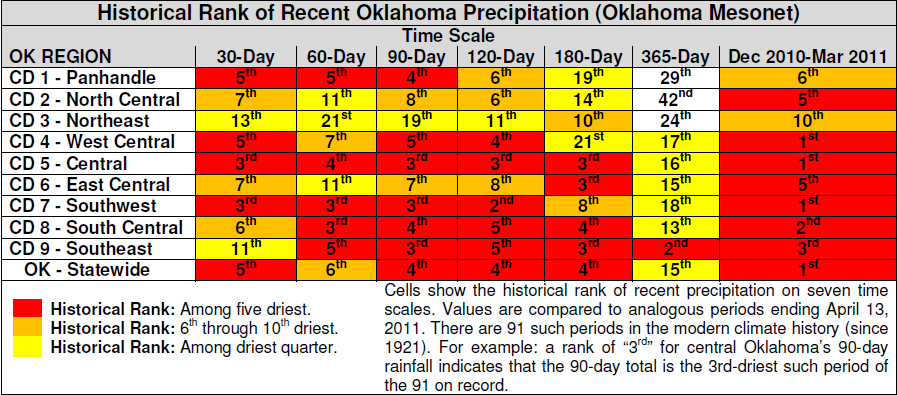
on a long-term basis. That is exemplified by the following table which shows
the historical rainfall rankings for the nine climate divisions in the state, as
well as for the state as a whole.


The color scheme makes it easy to gauge the severity of the drought. Basically,
the more red you see the drier it has been compared to history (red = bad? Take
it away OSU fans!!). Notice the 365-day ranking for the southeast? That
2nd-driest mark amounts to a deficit of nearly 20". With an average rainfall
total of 31.75", that places the current period less than 3" ahead of the worst
such period on record for that area (Apr 14, 2010 - Apr 13, 2011).

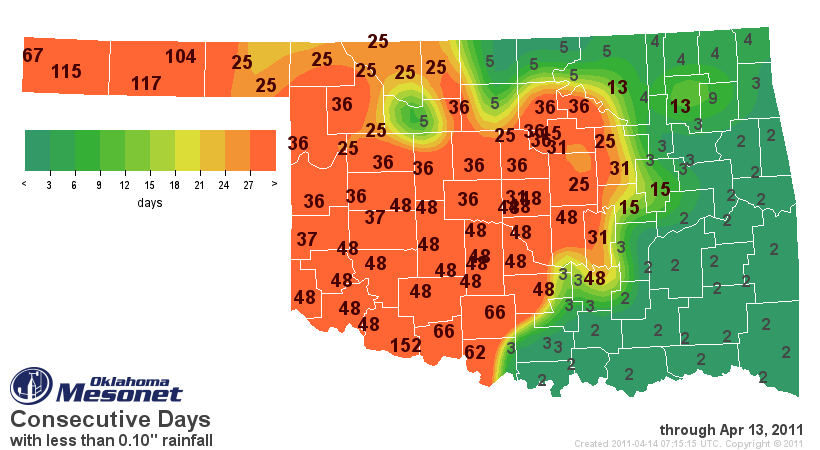
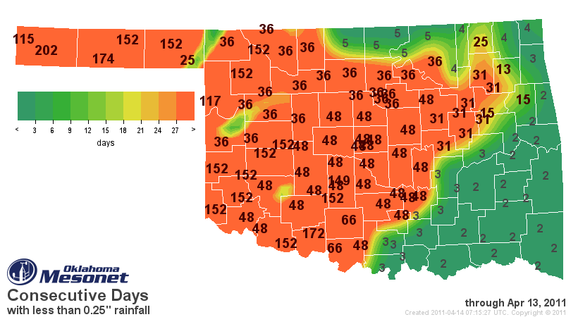
As an exclamation point, check out the consecutive days without 0.10" and 0.25"
of rain maps from the Oklahoma Mesonet. Grandfield has now gone 152 days without
a measly tenth of an inch in a single day and Boise City is at 202 days without
a quarter of an inch.


So depending on where you are at today, enjoy your tornadoes (east), 60 mph
non-storm wind gusts (NW), 5% RH (southwest), blowing dust (west of I35) and
your 203rd consecutive day without a quarter-inch of rain (Boise City).

Gary McManus
Associate State Climatologist
Oklahoma Climatological Survey
(405) 325-2253
gmcmanus@mesonet.org
April 14 in Mesonet History
| Record | Value | Station | Year |
|---|---|---|---|
| Maximum Temperature | 97°F | HOOK | 2003 |
| Minimum Temperature | 16°F | EVAX | 2022 |
| Maximum Rainfall | 3.12″ | GUTH | 2012 |
Mesonet records begin in 1994.
Search by Date
If you're a bit off, don't worry, because just like horseshoes, “almost” counts on the Ticker website!