Ticker for March 16, 2011
MESONET TICKER ... MESONET TICKER ... MESONET TICKER ... MESONET TICKER ...
March 16, 2011     March 16, 2011     March 16, 2011     March 16, 2011


Wheat Killer


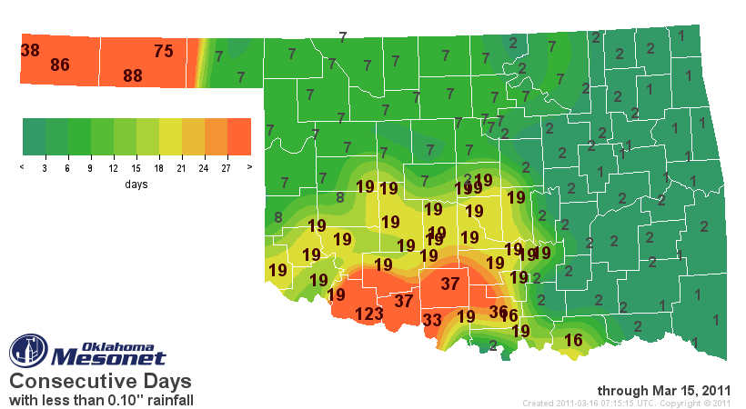
Yes, you are reading that correctly. It has now been 123 days since our Mesonet
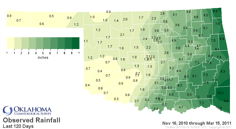
site at Grandfield has recorded 0.10 inches of rainfall in a single day. In
fact, they have only had 0.3 inches in the last 120 days, dating back to
November 16, 2010.


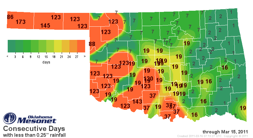
Much of the western Oklahoma is suffering a similar fate. I can't bring myself
to look at the 0.25-inch map, so I'm posting this with my eyes closed.


Rats, I had to sneak a peak just to make sure I didn't post one of my many
pictures of Slim Whitman. Ugly ugly ugly (and I'm not talking about Slim,
who is a very handsome man and an even better singer).

We have also gotten word of livestock sell-offs and a devastated winter wheat
crop in parts of south central Oklahoma, so I would imagine the crops to the
west of there are in similar shape. This is in addition to word from last week
that the dryland wheat crop in the western Panhandle will not materialize this
year.

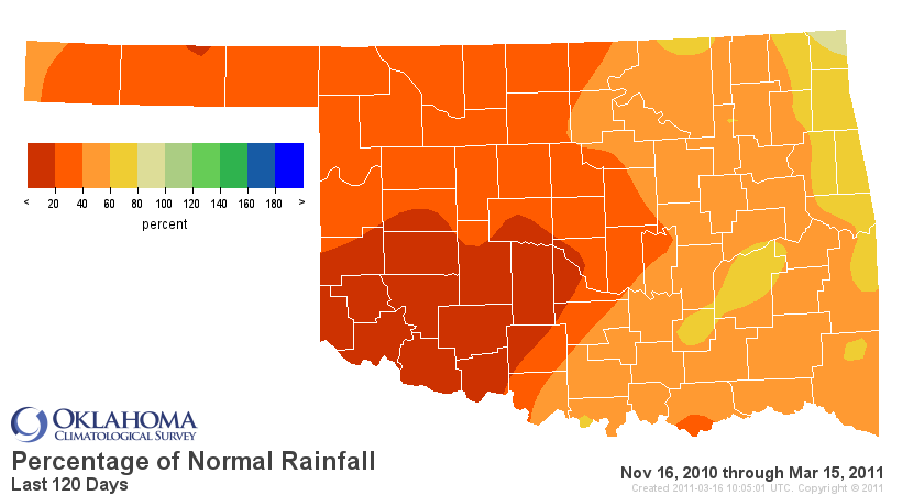
Over the last 120 days, southwestern Oklahoma has had an average of 0.77 inches
of rainfall (-4.96 inches below normal, 13% of normal) to rank as the 2nd driest
such period since 1921 for that part of the state. Here is a look at all areas
of the state over the last 120 days:

Region         Total Rainfall  Dep. from Normal  Pct. of Normal  Rank since 1921
Panhandle            0.86"           -2.31"           27%            7th Driest
N. Central           1.86"           -3.92"           32%            7th Driest
Northeast            5.50"           -3.91"           58%           15th Driest
W. Central           1.09"           -4.10"           21%            4th Driest
Central              2.42"           -5.79"           29%            3rd Driest
E. Central           6.43"           -5.24"           55%           12th Driest
Southwest            0.77"           -4.96"           13%            2nd Driest
S. Central           4.67"           -5.24"           47%            9th Driest
Southeast            8.03"           -6.69"           55%            6th Driest
Statewide            3.47"           -4.68"           43%            5th Driest


To put it bluntly, things are serious in the western one-half of Oklahoma. *IF*
we don't get rain soon out in that part of the state, expect a brief green-up
that will take advantage of the available soil moisture, then a rapid decline
to dormant/dead vegetation once that resource is gone. Keep in mind that the
soil moisture will also be depleted thanks to increasing daylight hours and
temperatures. In turn, that will mean a prolonged wildfire season.

The Norman NWS forecasters are indicating the possibility of a more active
weather pattern next week, so there is hope. The long-range outlooks for the
rest of spring will be out tomorrow, but please keep in mind the skill on those
diminish as we get further into spring, especially for precipitation.

Here is the bottom line: a fall-through-spring drought in Oklahoma can be a
wheat-killer, plain and simple. We have seen that in our recent past
(Fall 2005-Winter 06, 2008-09) and it is occurring now for some parts of
Oklahoma.

Writing a Ticker like this has almost guaranteed rain in the past. We'll keep
our fingers crossed.

Gary McManus
Associate State Climatologist
Oklahoma Climatological Survey
(405) 325-2253
gmcmanus@mesonet.org
March 16 in Mesonet History
| Record | Value | Station | Year |
|---|---|---|---|
| Maximum Temperature | 91°F | BEAV | 2015 |
| Minimum Temperature | 11°F | BOIS | 2005 |
| Maximum Rainfall | 3.01″ | CALV | 1998 |
Mesonet records begin in 1994.
Search by Date
If you're a bit off, don't worry, because just like horseshoes, “almost” counts on the Ticker website!