Ticker for March 17, 2011
MESONET TICKER ... MESONET TICKER ... MESONET TICKER ... MESONET TICKER ...
March 17, 2011 March 17, 2011 March 17, 2011 March 17, 2011
Things are getting droughtier and droughtier
I couldn't mention this yesterday since the map was not due to be released until
today, but OCS asked the U.S. Drought Monitor author this week to introduce "D3" or
"extreme drought" into Tillman and part of Cotton counties. That change is now
reflected in the new map.
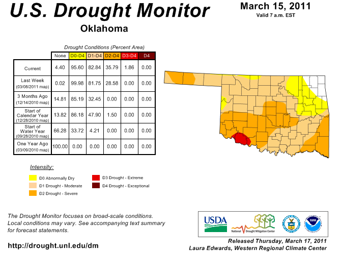
Note that the date says March 15, 2011. The cutoff time for any new precipitation
to be considered in the rendering of the map is 12Z (or 7 a.m.) each Tuesday. The
map is new today, however. As you can see, a D3 designation is indeed present in
the southwest. That was based upon several factors, not the least of which was
the area has had less than a half of an inch of rain in the last 120 days, as
detailed yesterday. Also note that D2 (severe drought) has spread in the
southeast and the southwest as well as in the Oklahoma Panhandle.
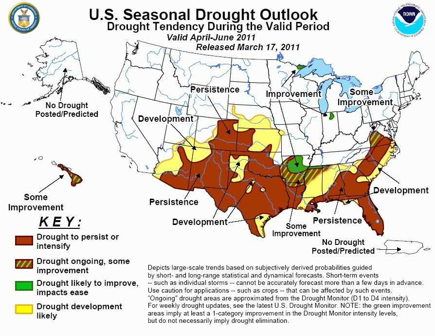
A new drought outlook product was also released by the NWS' Climate Prediction
Center this morning. In their mind, prospects are bleak for Oklahoma, save the
far eastern edge of the state. For the rest, they see drought persisting or
intensifying for April through June.
La Nina still has enough "oomph" left to give an increased chance of above
normal temperatures and below normal precipitation for western Oklahoma during
April.
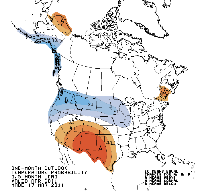
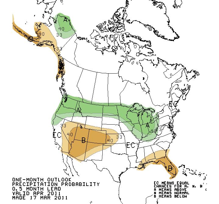
With La Nina fading away, the loss of a primary climate driver reduces
CPC's confidence in any long-range temperature or precipitation forecasts, as
evidenced by the latest April-June outlooks.
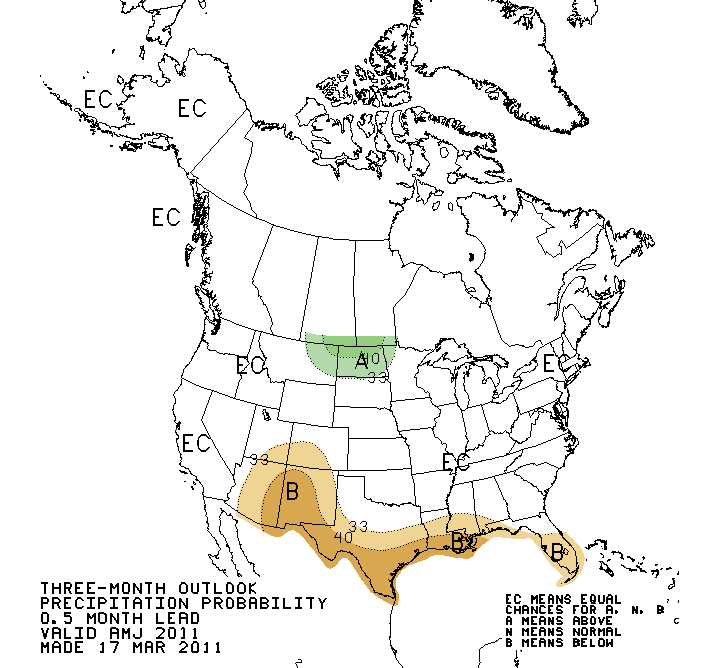
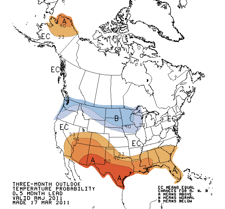
Other than the slight increased chance of above normal temperatures in southern
and northwestern Oklahoma, both maps show an abundance of "EC" or "Equal
Chances". That indicates the forecasters have no confidence in any forecast
of above-, below-, or near-normal chances ... basically they give each a 33%
chance of occurring.
Yes, it's a punt. As I've cautioned before, though, the long-range outlooks
have less skill as we go from winter into spring (and summer), especially
without a strong climate driver, like El Nino or La Nina.
Now it's time for Mother Nature to return that punt for a touchdown.
Gary McManus
Associate State Climatologist
Oklahoma Climatological Survey
(405) 325-2253
gmcmanus@mesonet.org
March 17 in Mesonet History
| Record | Value | Station | Year |
|---|---|---|---|
| Maximum Temperature | 95°F | ALTU | 2011 |
| Minimum Temperature | 13°F | BOIS | 2000 |
| Maximum Rainfall | 3.03″ | BESS | 2008 |
Mesonet records begin in 1994.
Search by Date
If you're a bit off, don't worry, because just like horseshoes, “almost” counts on the Ticker website!