Ticker for March 8, 2011
MESONET TICKER ... MESONET TICKER ... MESONET TICKER ... MESONET TICKER ...
March 8, 2011      March 8, 2011      March 8, 2011      March 8, 2011


Rain!

Some parts of Oklahoma are beginning to look like something out of a Frank
Herbert novel ... "Whoa. Sandworms. You hate 'em right?" (I think I just mixed
"Dune" with "Beetle Juice". Oh yes, I'm well versed in the classics!)

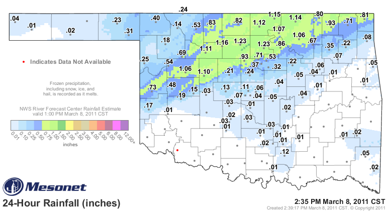
We had some nice rain totals overnight and into today, with more expected. Again,
with the current drought situation, none of these are a drought killer, but
they're definitely cumulative. Here are some of the more hefty rain totals from
the Oklahoma Mesonet thus far:

Breckinridge	1.23	   Wynona	1.06
Red Rock	1.23	   Nowata	0.93
Lahoma	        1.16	   Marshall	0.93
Newkirk	        1.15	   Pawnee	0.86
Foraker	        1.14	   Cherokee	0.83
Fairview	1.11	   Miami	0.81
Blackwell	1.10	   Copan	0.80
Watonga	        1.10	   Medford	0.76
Burbank	        1.07	   Cheyenne	0.73
Putnam	        1.06	   Vinita	0.70

North central Oklahoma produces the most wheat in the state, so those totals
are absolutely huge, even at just over an inch.


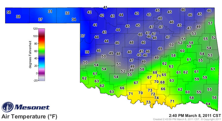
Storms are now firing up in eastern Oklahoma. A look at the 2:40 p.m. air
temperature map gives me vertigo, so I'll throw it your way to interpret.


I think there are a couple of fronts in there, maybe a dryline, wet-bulbing,
etc.

As a true climatologist, I'll let you know tomorrow how it all turns out.

Gary McManus
Associate State Climatologist
Oklahoma Climatological Survey
(405) 325-2253
gmcmanus@mesonet.org
March 8 in Mesonet History
| Record | Value | Station | Year |
|---|---|---|---|
| Maximum Temperature | 84°F | HOLL | 2002 |
| Minimum Temperature | 7°F | SEIL | 2008 |
| Maximum Rainfall | 3.01″ | BESS | 2016 |
Mesonet records begin in 1994.
Search by Date
If you're a bit off, don't worry, because just like horseshoes, “almost” counts on the Ticker website!