Ticker for March 1, 2011
MESONET TICKER ... MESONET TICKER ... MESONET TICKER ... MESONET TICKER ...
March 1, 2011 March 1, 2011 March 1, 2011 March 1, 2011
OCS PRESS RELEASE: February Weather Full of Extremes, and Records
In a state accustomed to extreme weather, February was a bit startling to even
the most seasoned veteran of Mother Nature?s whimsy. The roller coaster ride
began on the month?s first day with a crippling blizzard and ended on its last
with tornado warnings. The month was peppered with records, including the
state?s all-time lowest minimum temperature and greatest 24-hour snowfall total.
Those extremes occurred amidst the larger backdrop of an intensifying drought
across the western two-thirds of the state.
Statewide temperature and precipitation averages look relatively boring in
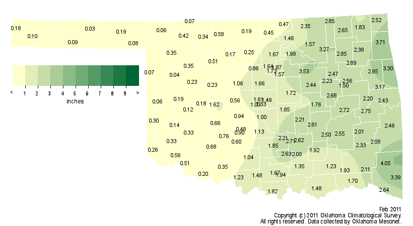
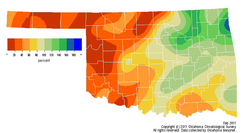
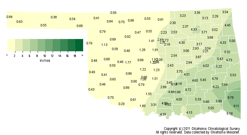
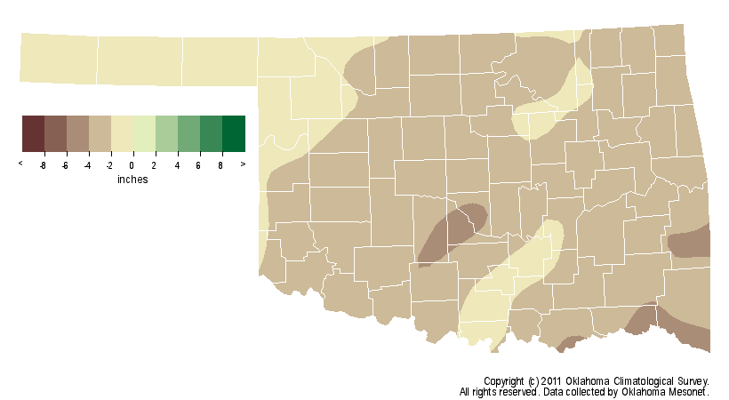
comparison to the singular extreme events. The statewide average precipitation
total finished a tad below normal at 1.36 inches, the 55th driest February
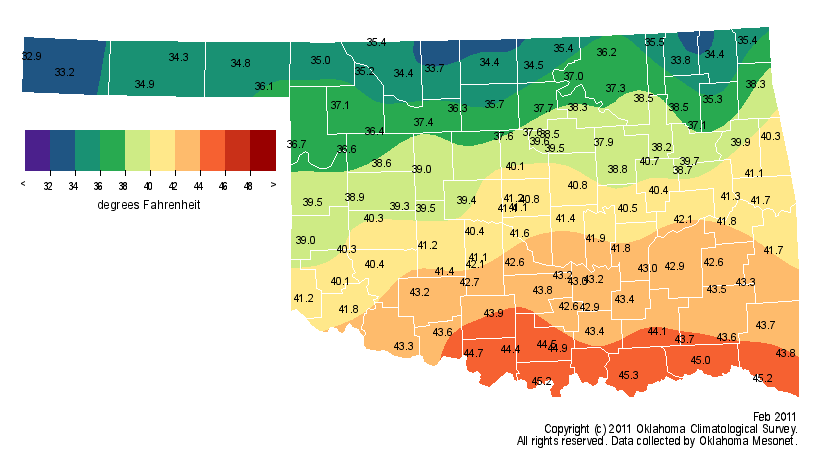
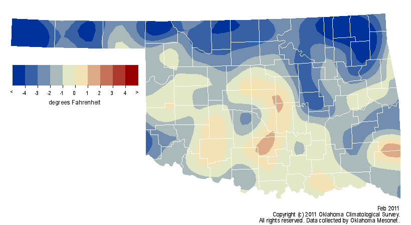
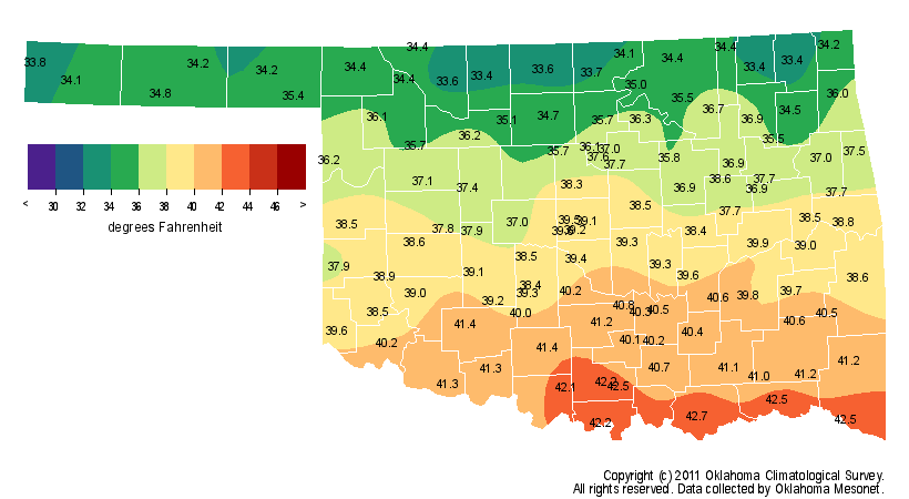
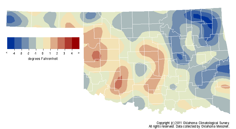
since 1895. Temperatures moderated throughout the month and ranked as the 43rd
coolest on record, around 2 degrees below normal. February also marks the end
of the climatological winter, which goes in the books as the 32nd coolest and
11th driest on record.
NOTE: Mesonet precipitation maps are of liquid equivalent amounts and will be
an underestimate in some areas due to blowing snow.
February:
Winter:
The month?s first 10 days brought three separate snowstorms and a prolonged
visit with arctic air. The first storm combined heavy sleet and snow with winds
of over 60 mph to produce blizzard conditions over much of the state. Tulsa set
a record for its snowiest day ever with 13.2 inches on the first. Oklahoma City
reported 12.1 inches to set the record for its snowiest day ever in February.
Totals of 10-15 inches were common across the northeast with 1-6 inches
reported in southern Oklahoma. Another 2-6 inches fell across the eastern half
of the state on the fourth before a more powerful storm system moved in on the
ninth. That storm dumped over 20 inches of snow in the northeast, including 27
inches in less than 24 hours at Spavinaw, breaking the state?s all-time 24-hour
snowfall record. The final epitaph of those three storms was remarkable.
Preliminary reports indicate approximately 40 inches of snow fell in some areas
in the northeast. The 22.5 inches of snow ranks February as the snowiest of any
month in Tulsa?s history and helps its seasonal total of 26.1 inches to rank as
the most on record as well. Oklahoma City?s final total of 18.9 inches shatters
its previous February record of 12.9 inches from 1913.
The snow cover on the 10th combined with calm winds and clear skies to drop
temperatures into territory never before seen in Oklahoma. The Oklahoma Mesonet
site at Nowata reached 31 degrees below zero, shattering the record for lowest
temperature ever recorded in the state. The previous record of 27 degrees below
zero was set three times previously at different locations in Oklahoma?s first
half-century of statehood, most recently at Guthrie in January 1947. Lows from
15-25 degrees below zero were reported across the northern half of the state
that morning. That set the stage for yet another extreme as the temperature at
Nowata rose to 79 degrees seven days later on the 17th. That 110-degree
temperature swing within a week was the greatest such change within seven days
in Oklahoma history. Fifteen other Mesonet sites achieved a 100-degree swing
within that same period, a feat accomplished only twice previously in Oklahoma
since 1890.
Warm weather was the rule for the second half of the month. Widespread
record-high temperatures were recorded on the 17th with temperatures in the 70s
and 80s statewide. Strong southerly winds brought more warmth on the 27th with
the Oklahoma Mesonet stations at Grandfield and Walters both recording a high
temperature of 90 degrees, the month?s highest reading.
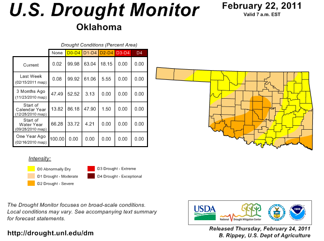
The ongoing drought was the other big story during February. The prodigious
snowfalls in the northeast helped that area somewhat, but the western half of
the state continued with very dry conditions. Much of western Oklahoma received
less than a half-inch of precipitation during the month. That continued the
ongoing drought intensification in that part of the state, a reflection of the
dry winter. The Panhandle, north central, west central and southwestern regions
of the state all experienced winters that were within their top-five driest on
record, dating back to 1895.
The most recent U.S. Drought Monitor depiction indicates moderate-to-severe
drought continuing for much of Oklahoma:
FEBRUARY BY THE NUMBERS:
Statewide average precipitation: 1.36 inches, 0.40 inches below normal
Driest location: Hooker and Camargo, 0.03 inches
Wettest location: Mt. Herman, 4.05 inches
Statewide average temperature: 39.6 degrees, -2.1 degrees below normal
Highest temperature: 90 degrees, Grandfield and Walters
Lowest temperature: -31 degrees, Nowata
Warmest location (monthly average temperature): Durant, 45.3 degrees
Coolest location (monthly average temperature): Kenton, 32.9 degrees
Gary McManus
Associate State Climatologist
Oklahoma Climatological Survey
(405) 325-2253
gmcmanus@mesonet.org
March 1 in Mesonet History
| Record | Value | Station | Year |
|---|---|---|---|
| Maximum Temperature | 95°F | NEWP | 2006 |
| Minimum Temperature | 7°F | GOOD | 2001 |
| Maximum Rainfall | 1.86 inches | HUGO | 1997 |
Mesonet records begin in 1994.
Search by Date
If you're a bit off, don't worry, because just like horseshoes, “almost” counts on the Ticker website!