Ticker for November 5, 2010
MESONET TICKER ... MESONET TICKER ... MESONET TICKER ... MESONET TICKER ...
November 5, 2010 November 5, 2010 November 5, 2010 November 5, 2010
Pass the Mashed Potatoes
This Ticker will also describe the turkey I normally get on Thanksgiving ...
cold and dry.
************************************
Dry Conditions Spreading in Oklahoma
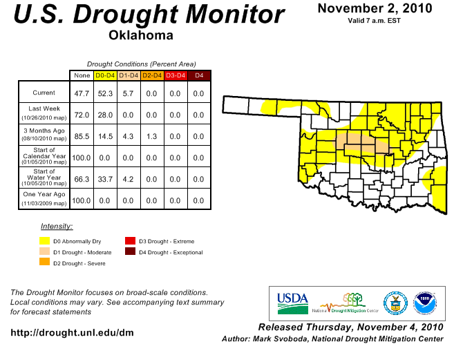
The latest U.S. Drought Monitor shows the spread of dry conditions across
the state with moderate drought (D1) being added to central Oklahoma and
abnormally dry (D0) conditions added to much of northeastern Oklahoma.
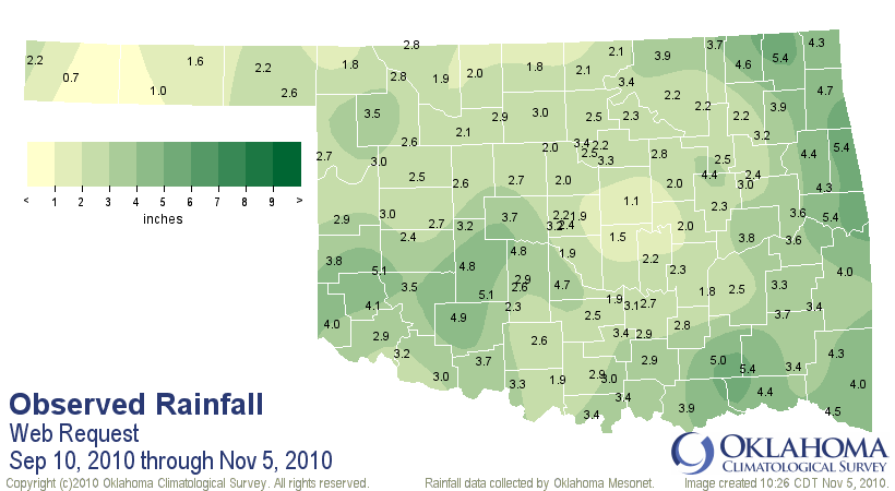
The rains of a couple of weeks ago certainly helped the southern half of
the state, but the northern half of the state continues to struggle for the
last 30-60 days. In fact, since Tropical Storm Hermine (NOT EARL!!) dropped
a good 2-6 inches over much of eastern Oklahoma, the spigot had been largly
just dripping.
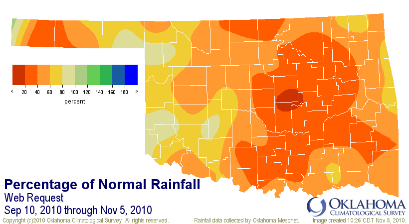
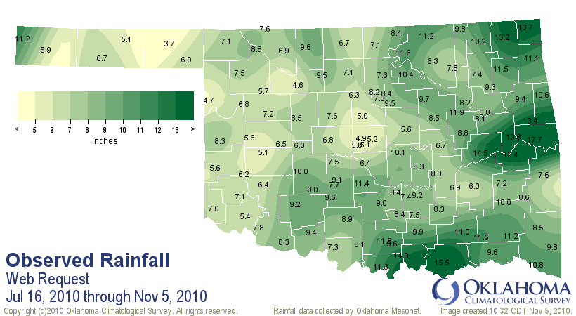
Then on the longer term, we can go back to the summer months and observe what
has occurred since the rains quit in mid-July:
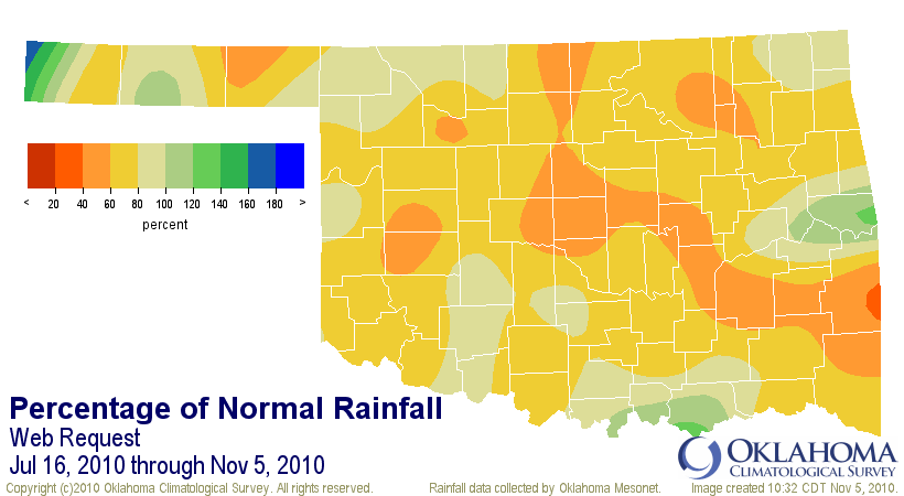
Much of the state has had from 40-60% of normal rainfall over that time with
only a few pockets of significant surplus. Remember, much of the second half of
summer saw the state mired in triple-digit temperatures. That in itself acts
as a moisture deficit since it tends to increase evaporation.
Since July 16, the statewide average rainfall total for Oklahoma is 8.46 inches,
3.36 inches below normal and the 17th driest such period on record for the
state. The central region of the state is suffering its 14th driest July 16-
November 5 on record. Oklahoma City has had a paltry 5.08 inches during that
period and Tulsa has had 5.92 inches.
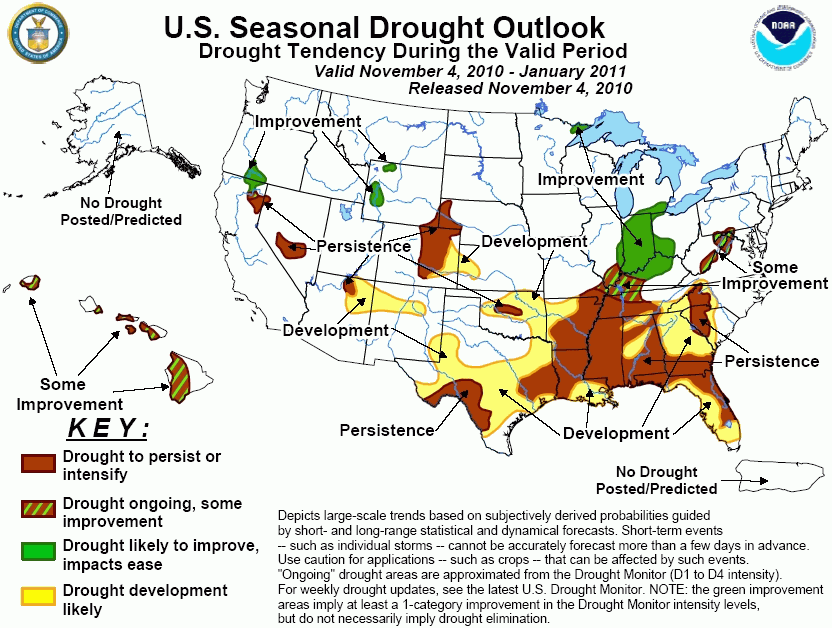
Yes, we need rainfall. Our secondary wet season has disappointed most, and
prospects are diminished thanks to our friend La Nina out in the pacific. The
Drought Outlook shows a tendency for persistence and development of drought in
Oklahoma (and much of the southeast) through January 2011 due in large part to
that climate phenomenon.
Eventually we'll see a storm system break through this upper-level ridging and
approach us from the west. We'll get southerly winds and the Gulf of Mexico
will open up to us again and we'll get some rainfall. Keeping with the
Thanksgiving theme ... any rain we can get here in the next few weeks is gravy.
Yeah, sorry about that one.
******************************
Temperatures Plummet Overnight
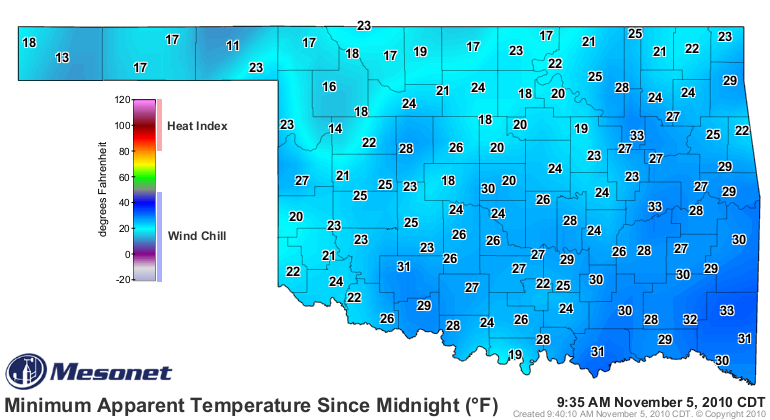
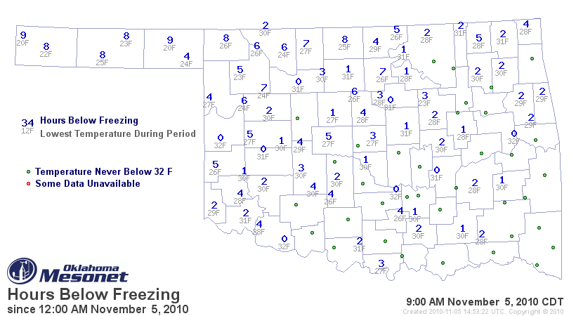
Low temperatures dropped into the 20s and 30s statewide, nary a 40 to be found,
although we got close to the teens in the Panhandle. After last night, most of
the state how now seen a low temperature below freezing this cool season.
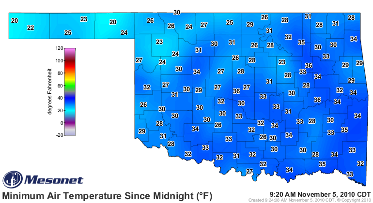
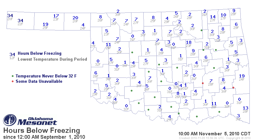
If you want teens, though, just add the winds to get some lovely wind chill
values.
Many areas dropped below freezing for more than just a few hours.
The Mesonet's 15 Lowest Temperatures this morning
Coolest Minimum Temperatures
1 - Beaver 20.0F 8:25 am
2 - Kenton 20.1F 8:30 am
3 - Boise City 22.1F 6:50 am
4 - Hooker 23.2F 8:30 am
5 - Woodward 23.2F 6:40 am
6 - Oilton 23.5F 7:20 am
7 - Camargo 23.7F 6:05 am
8 - Seiling 24.4F 8:00 am
9 - Alva 24.5F 8:05 am
10 - Slapout 24.5F 8:10 am
11 - Goodwell 24.7F 7:10 am
12 - Medford 25.2F 6:15 am
13 - Buffalo 25.6F 7:40 am
14 - Sulphur 25.7F 7:45 am
15 - Newkirk 25.8F 7:45 am
The 20 degrees recorded at Beaver ties for the coldest temperature seen this
season. Kenton also recorded at 20-degree reading on October 28.
So there you have it. We need some rain, and the dry cold fronts are getting
tiresome.
By the way, anybody inviting me over for Thanksgiving? I may not be welcome at
my usual stops this year. Seriously, I eat ham too!
Gary McManus
Associate State Climatologist
Oklahoma Climatological Survey
(405) 325-2253
gmcmanus@mesonet.org
November 5 in Mesonet History
| Record | Value | Station | Year |
|---|---|---|---|
| Maximum Temperature | 91°F | BURN | 2017 |
| Minimum Temperature | 20°F | BEAV | 2010 |
| Maximum Rainfall | 4.60″ | IDAB | 2000 |
Mesonet records begin in 1994.
Search by Date
If you're a bit off, don't worry, because just like horseshoes, “almost” counts on the Ticker website!