Ticker for November 2, 2010
MESONET TICKER ... MESONET TICKER ... MESONET TICKER ... MESONET TICKER ...
November 2, 2010 November 2, 2010 November 2, 2010 November 2, 2010
October?s Weather Warm and Dry, November and December Could Be Similar
Dry and warm conditions continued over much of the state, although a late-month
drink gave a bit of relief to drought-plagued southwestern Oklahoma. A powerful
upper-level storm that brought significant rains to the southwestern quarter of
the state kept this October from finishing as one of the state?s top-ten driest
on record. Despite that moisture, however, much of the state still received a
meager 20-60 percent of normal rainfall for the month. According to data from the
Oklahoma Mesonet, October ranked as the 30th driest since records began in 1895
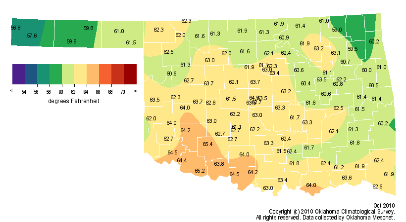
with a statewide average of 1.74 inches, 1.64 inches below normal. Temperatures
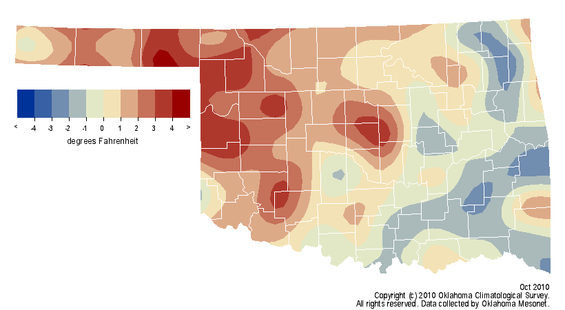
finished above normal for the third consecutive month as well with a statewide
average of 62 degrees, 0.7 degrees above normal, to rank the month as the 51st
warmest on record. In a bit of a change from recent warm months, high
temperatures led the way at 2.6 degrees above normal while low temperatures
were 1.4 degrees below normal.
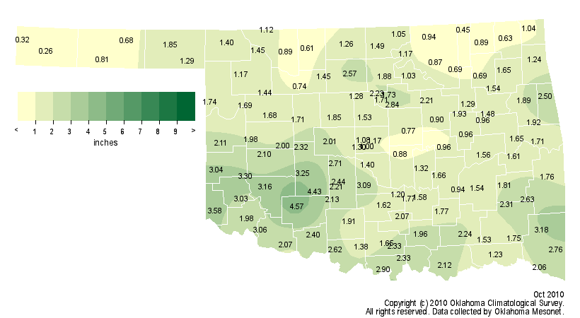
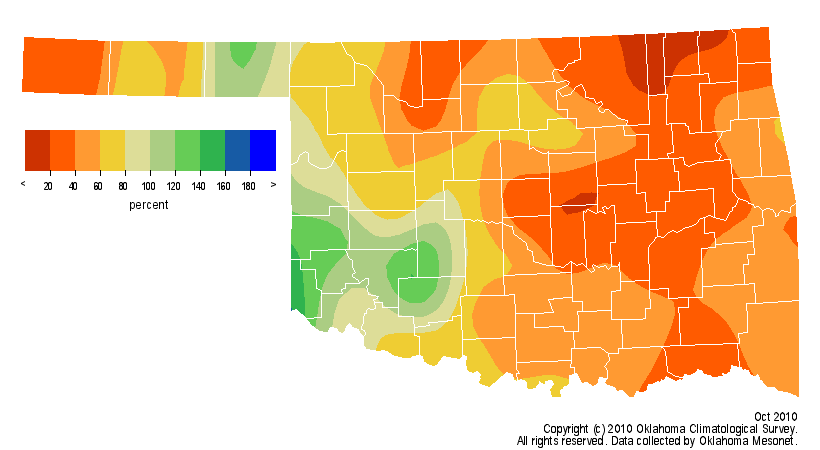
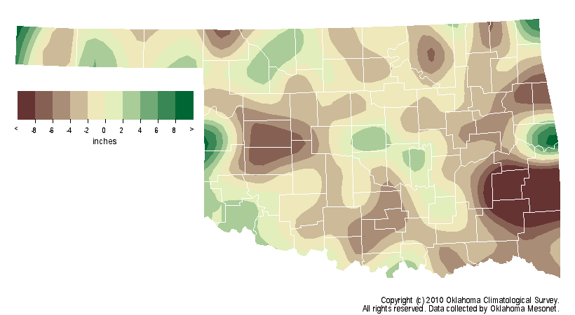
Only southwest Oklahoma saw a significant moisture surplus with 3-5 inches of
rain. Northeastern Oklahoma was particularly dry with an average total of 1.04
inches, more than 2 inches below normal and the 14th driest on record for that
area. The Oklahoma Mesonet site at Medicine Park led the state with 4.57
inches. That stands in stark contrast to Boise City where little more than a
quarter of an inch fell. Of the Mesonet?s 120 stations, 21 saw less than an
inch of rainfall during the month while 79 had less than 2 inches.
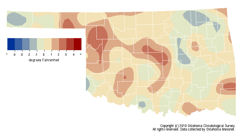
Temperatures were 3-4 degrees above normal in parts of the northwest to 1-2
degrees below normal in the southeast. The average temperature for west central
Oklahoma was 2.4 degrees above normal to rank as the 23rd warmest October on
record. Southeastern Oklahoma, on the other hand, fell 0.5 degrees below normal
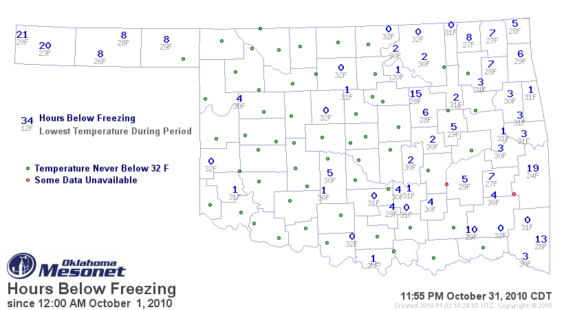
to rank as the 40th coolest. Not surprisingly, Kenton was the coolest locale in
the state with an average temperature of 56.8 degrees. Medicine Park was not
only the wettest site but also the warmest as well with an average temperature
of 65.4 degrees. The highest recorded temperature during the month was 92
degrees at Buffalo on the seventh. Kenton came in with the lowest temperature
of 20 degrees on the 28th. Freezing temperatures were recorded at 64 Oklahoma
Mesonet stations during October.
Barring a cool or wet final two months, the year is on pace to finish warmer-
and drier-than-normal. Through October, the 2010 statewide average temperature
was 63.2 degrees, 0.3 degrees above normal and the 39th warmest such period on
record. On the precipitation side, the statewide average was 2.61 inches below
normal at 29.24 inches. That ranks this January-October period as the 53rd
driest on record.
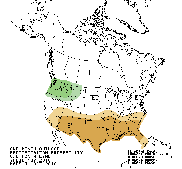
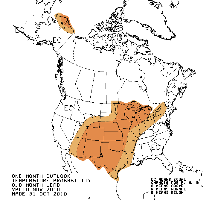
The National Weather Service?s Climate Prediction Center holds little hope for
a cool or wet finish to the year. Long-range outlooks for both November and
November-January indicate an increased chance for above normal temperatures and
below normal precipitation. Those outlooks are influenced by a moderate-to-
strong La Ni?a that developed in the waters of the equatorial Pacific during
the summer. During La Ni?a events, Oklahoma and the southern United States
exhibit an increased tendency for warmer and drier winters.
Gary McManus
Associate State Climatologist
Oklahoma Climatological Survey
(405) 325-2253
gmcmanus@mesonet.org
November 2 in Mesonet History
| Record | Value | Station | Year |
|---|---|---|---|
| Maximum Temperature | 93°F | BURN | 2017 |
| Minimum Temperature | 15°F | KENT | 2004 |
| Maximum Rainfall | 4.12″ | HOLL | 2024 |
Mesonet records begin in 1994.
Search by Date
If you're a bit off, don't worry, because just like horseshoes, “almost” counts on the Ticker website!