Ticker for July 5, 2010
MESONET TICKER ... MESONET TICKER ... MESONET TICKER ... MESONET TICKER ...
July 5, 2010       July 5, 2010       July 5, 2010       July 5, 2010


Keep Your Powder Dry

The Ticker Staff hopes you enjoyed the lovely and soggy July 4th weekend. And for
those of you still on holiday, the joy continues. Heavy rains have brought severe
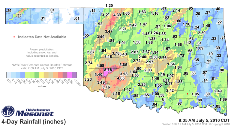
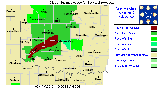
flooding to parched areas in western Oklahoma. A series of gully-washers
inundated parts of Kiowa County with nearly 9 inches of rainfall, and
surrounding areas have had from 3-7 inches. You can thank a not-so-unusual mix
of ingredients for our toad-stranglers...lots of deep tropical moisture due
to the remnants of Hurricane Alex and weak upper-level flow. The result is
what we sometimes call "warm rain." The lack of thunder has been very telling.
It feels very tropical out there and that is not a mistake, so welcome to Costa
Oklahoma! These patterns seem persistent due to that lack of upper-level flow
since there is a lack of impetus to move the upper-air patterns along. Instead
of our endless hot-and-dry, we're now having soggy-cracker weather.

Take a look (and preview) at a new-look Mesonet rainfall map, now with lots of
color thanks to the NWS River Forecast Center! We bought the 64-crayon box WITH
the sharpener for those.


The result is another colorful map, this time from the NWS office in Norman:


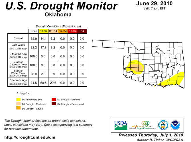
And one of our jobs at the Oklahoma Climatological Survey is to provide local
expertise to the U.S. Drought Monitor folks, and needless to say we'll be
recommending plenty of changes and this map from last week will be mostly free
of those dreaded yellows and oranges:


Here are the top rainfall values since July 2nd:

Hobart	        8.68		Camargo	        3.49
Fort Cobb	5.65		Seiling	        3.47
Mangum	        5.25		Hinton	        3.44
Alva	        4.39		Hollis	        3.22
Medicine Park	4.30		El Reno	        3.21
Retrop	        4.27		Apache	        3.18
Weatherford	3.78		Grandfield	3.18
Tipton	        3.73		Altus	        3.00
Bessie	        3.50

*****************

Always end with a BANG!

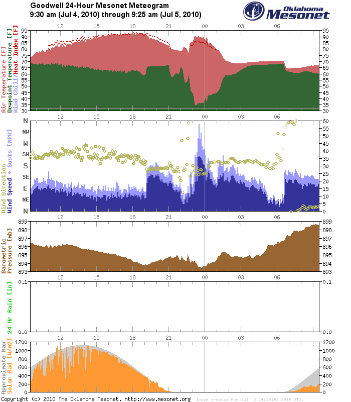
For those missing the summer heat, you should have been in Goodwell last night
between 10-11 PM and you would have experienced temperatures jumping from the
mid-70s to the mid-90s in an hour to go along with winds gusting to nearly 60
mph. The tell-tale signs of a heat burst are evident on the Goodwell meteogram.
Notice the rise in temperature that coincides the strong winds and dramatic
drop in dewpoint:


Gary McManus
Associate State Climatologist
Oklahoma Climatological Survey
(405) 325-2253
gmcmanus@mesonet.org
July 5 in Mesonet History
| Record | Value | Station | Year |
|---|---|---|---|
| Maximum Temperature | 107°F | WALT | 2011 |
| Minimum Temperature | 50°F | KENT | 2004 |
| Maximum Rainfall | 6.39 inches | HOBA | 2010 |
Mesonet records begin in 1994.
Search by Date
If you're a bit off, don't worry, because just like horseshoes, “almost” counts on the Ticker website!