Ticker for July 1, 2010
MESONET TICKER ... MESONET TICKER ... MESONET TICKER ... MESONET TICKER ...
July 1, 2010       July 1, 2010       July 1, 2010       July 1, 2010


June's in the books, May tornadoes are not

According to tornado aficionado and all-around good guy Doug Speheger of the
Norman NWS office, May's preliminary tornado count has now risen to 67. There
are still tornado reports to investigate, however, so that could be headed even
higher. That solidly places May 2010 in second place, eclipsing May 1960's
61 twisters. The count remains well behind the 90 tornadoes of May 1999, which
includes the May 3-4 outbreak that devastated central Oklahoma. The count for
the year has risen to 70. Oklahoma normally sees 20 tornadoes during May and 53
for an entire year.

**********

June Climate Statistics

June?s weather was certainly calmer than May?s, although it did have its
moments, including a 500-year rainfall event and plenty of heat for everybody.
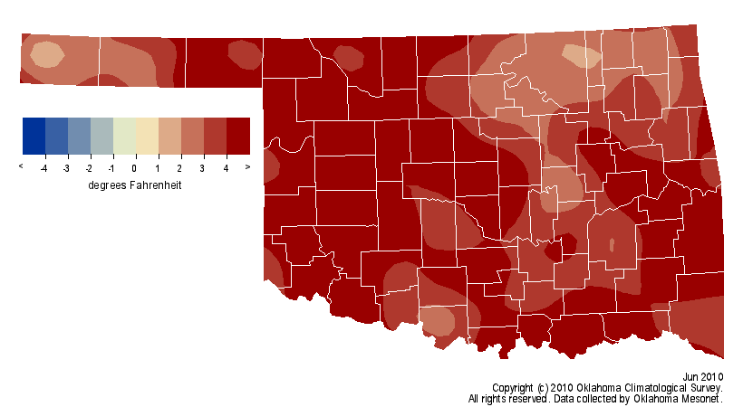
Data from the Oklahoma Mesonet place this June as the seventh warmest since
record keeping began in 1895 with a statewide average temperature of 80.6
degrees, 4.1 degrees above normal. Even the remarkable heat cannot top the
historic rains that fell in central Oklahoma on June 14, however. Rainfall
totals of 9-11 inches were widespread across the Oklahoma City metropolitan
area, with the Oklahoma City North Mesonet site topping the rain gauge at 11.04
inches. More than 9 inches of that total fell in less than six hours, and the
intensity bested both the 500-year 6-hour and 12-hour rainfall event maximums.
Severe flooding that occurred throughout central Oklahoma due to the heavy
rains left hundreds of homes and businesses damaged or destroyed. The official
observation of 7.62 inches from Will Rogers International Airport on the 14th
broke the previous record of 3.95 inches set on that day in 1930, and broke the
June calendar-day rainfall record of 6.75 inches.

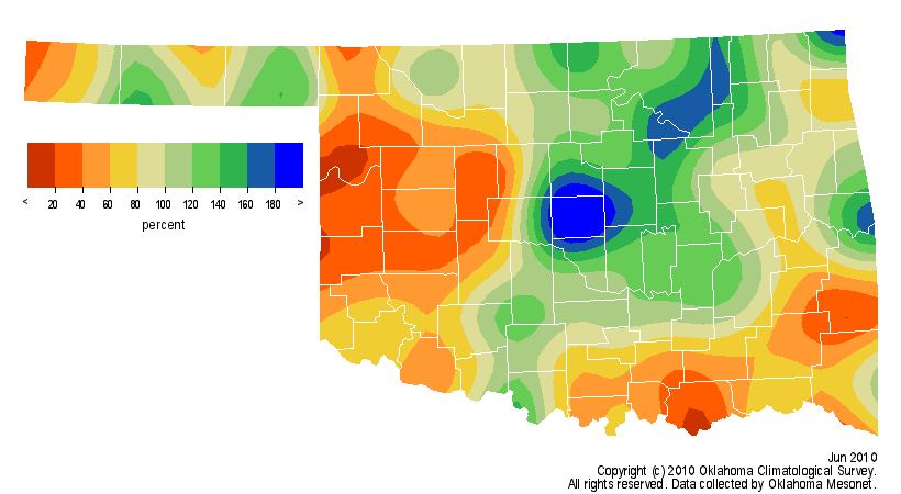
While central and northeastern parts of the state saw an abundant surplus of
moisture, other areas were left high and dry. The Oklahoma Mesonet site at
Camargo recorded less than 20 percent of normal rainfall for the month with a
meager total of 0.63 inches. Much of the western one-half and southeastern
one-third of the state saw totals of 20-60 percent of normal for the month.
West central Oklahoma had an average of 1.36 inches of rainfall and ranked as
the 11th-driest June on record for that area. Just to the east, however,
central Oklahoma had an average of 6.35 inches for the 26th-wettest June. The
statewide average was 3.90 inches, the 56th-wettest June on record despite a
deficit of 0.36 inches.


All areas of the state were abundantly warm for the month. The highest
temperature of the month was 104 degrees, recorded by Mesonet sites at Mangum
on June 5 and Hooker on June 10. The lowest temperature of 51 degrees was
recorded at Boise City on the 15th. Severe weather slowed considerably
following the active May, although flooding reports associated with the June 14
heavy rain event were understandably numerous. A handful of possible tornadoes
were reported in the northwest on June 13, but those numbers are still
preliminary.

Gary McManus
Associate State Climatologist
Oklahoma Climatological Survey
(405) 325-2253
gmcmanus@mesonet.org
July 1 in Mesonet History
| Record | Value | Station | Year |
|---|---|---|---|
| Maximum Temperature | 110°F | ALVA | 1997 |
| Minimum Temperature | 50°F | EVAX | 2017 |
| Maximum Rainfall | 5.82 inches | PAWN | 2016 |
Mesonet records begin in 1994.
Search by Date
If you're a bit off, don't worry, because just like horseshoes, “almost” counts on the Ticker website!