Ticker for June 4, 2010
MESONET TICKER ... MESONET TICKER ... MESONET TICKER ... MESONET TICKER ...
June 3, 2010       June 3, 2010       June 3, 2010       June 3, 2010


Closing the books on a stormy May

The dull beginning to May gave hope to many that Oklahoma?s severe weather
season would bypass the state this year. With only three tornadoes and very
little in the way of other severe weather through May 9, that certainly seemed
possible. Those hopes were dashed by Mother Nature shortly thereafter, however,
and the month became one of the most violent in recent memory. While reports are
still preliminary, it appears likely that the count for May will exceed, 60
tornadoes. The latest count I saw from Norman NWS tornado black belt
Doug Speheger was 56 with more work still to do. That remains well behind the
90 tornadoes of May 1999, which includes the devastating May 3-4 outbreak that
devastated central Oklahoma. However, it stands a chance to eclipse the 61
tornadoes that touched down during May 1961 for second place. It would also best
the 59 tornadoes of May 2003. Oklahoma normally sees 20 tornadoes during May
and 53 for an entire year.

Plenty of severe weather came associated with the multitude of tornado reports.
Hail, severe straight-line winds and flash flooding were also common and
damaging hazards. A hailstorm on May 16 cut a swath of destruction from
northwest Oklahoma through Oklahoma City with numerous reports of golf ball to
softball size hail.

A story in the Oklahoman today details the costs of the May tornadoes and hail,
which could exceed a billion dollars:

http://www.newsok.com/losses-from-oklahomas-may-storms-likely-to-top-1-billion/article/3465717

And now for the exciting stuff! Well, if you are a climatologist ...

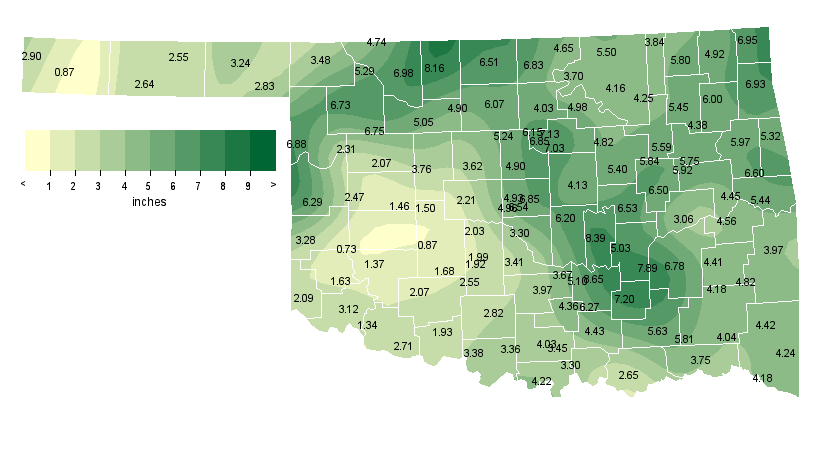
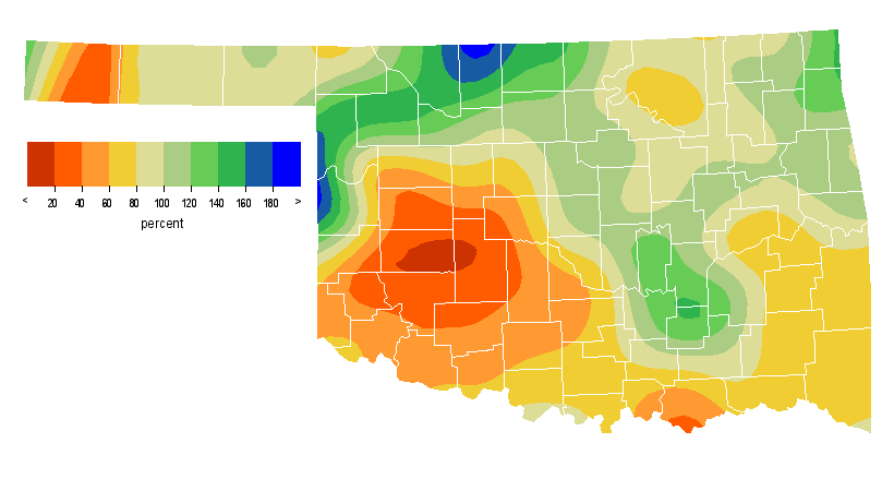
Data from the Oklahoma Mesonet rank the month as the 50th-driest May since
records began in 1895 with a statewide average of 4.35 inches of rainfall, a
little less than an inch below normal. The southern half of the state was quite
dry, especially in southwestern Oklahoma where the deficit for the month rose
to 3.12 inches, the 13th-driest May for that part of the state. Ada recorded
the most precipitation with 8.65 inches while Retrop in southwestern Oklahoma
came in with a paltry 0.73 inches. Check out the maps below showing the total
rainfall and percent-of-normal rainfall for May from the Oklahoma Mesonet.


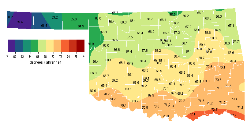
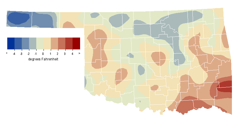
Even though the statewide average temperature finished near normal, most
regions of the state were anything but. Southeastern Oklahoma experienced its
23rd-warmest May at more than 2.4 degrees below normal while the Panhandle was
1.1 degrees below normal, the 35th coolest for that part of the state. Idabel
enjoyed the state?s highest average temperature for the month at 72.8 degrees
while Boise City was the coolest with a 59.3-degree reading. Tipton had the
highest temperature and the state?s first triple-digit reading of the year with
100 degrees on May 30. Boise City had the lowest temperature with 28 degrees on
May 2. These maps show the average temperatures and departure-from-normal
temperatures for May from the Oklahoma Meosnet.


Gary McManus
Associate State Climatologist
Oklahoma Climatological Survey
(405) 325-2253
gmcmanus@mesonet.org
June 4 in Mesonet History
| Record | Value | Station | Year |
|---|---|---|---|
| Maximum Temperature | 107°F | GRA2 | 2014 |
| Minimum Temperature | 43°F | EVAX | 2025 |
| Maximum Rainfall | 8.23 inches | GRAN | 1995 |
Mesonet records begin in 1994.
Search by Date
If you're a bit off, don't worry, because just like horseshoes, “almost” counts on the Ticker website!