Ticker for May 28, 2010
MESONET TICKER ... MESONET TICKER ... MESONET TICKER ... MESONET TICKER ...
May 27, 2010       May 27, 2010       May 27, 2010       May 27, 2010


Hurricane Season Could Be A Whopper

(Warning, the Ticker Staff brought their lunchpail today)

NOAA's Climate Prediction Center (CPC) issued their 2010 Atlantic Hurricane
Season Outlook and it doesn't look good, especially if there is still an oil
slick the size of South Carolina (from latest news reports) floating around in
the Gulf of Mexico. That just screams of a storm-surge environmental disaster.

Atlantic Hurricane Season

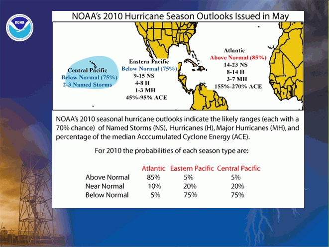
The CPC expects an "active to extremely active" hurricane season, which runs
from June 1-November 30. That means an 85% chance of an above-normal season,
a 10% chance of a near-normal season and a 5% chance of a below-normal season.


Some of the factors that influenced this outlook include:

1) The tropical multi-decadal signal, which has contributed to the high-
activity era in the basin since 1995. Eight of the last 15 seasons rank in
the top ten for the most named storms with 2005 in first place with 28 named
storms.
2) Exceptionally warm sea surface temps in the main development region. Record
warm temperatures ? up to four degrees Fahrenheit above average ? are now
present in this region.
3) Increasing chances of La Ni?a during the season. La Ni?a can increase
favorable hurricane conditions in the Atlantic by decreasing wind shear
(which can tear apart hurricanes) while El Ni?o brings more shear and less
favorable conditions.

In CPC's own words:

"We estimate a 70% probability for each of the following ranges of activity
this season:

* 14-23 Named Storms
* 8-14 Hurricanes
* 3-7 Major Hurricanes
* An ACE range of 155%-270% of the median."

ACE is an acronym for "Accumulated Cyclone Energy" index, which accounts for
the intensity and duration of named storms and hurricanes during the season.
An ACE value above 117% of the 1950-2000 median reflects an above-normal season.
An ACE value above 175% of the median reflects an exceptionally active (or
hyperactive) season (I'm out of my element here, but I suspect an ACE value of
270% means they've gone to plaid).

An important note to keep in mind is that this outlook is not a seasonal
hurricane LANDFALL forecast. It is feasible, of course, to have an extremely
active season with few landfalling storms. It's probably a good thing Oklahoma
is not in that area or that would guarantee 14-23 landfalling storms.

For the oil spill region, all above normal seasons have produced at least one
named storm in the Gulf of Mexico and 95% of those seasons have at least two
named storms in the Gulf. Most of this activity (80%) occurs during August-
October. However, 50% of above normal seasons have had at least one named storm
in the region during June-July.

What does this mean for Oklahoma? Tough to say, although an increase in tropical
storms can mean an increase in landfalling storms which can mean an increased
chance of Oklahoma being impacted by a remnant circulation.

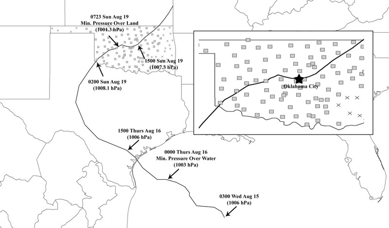
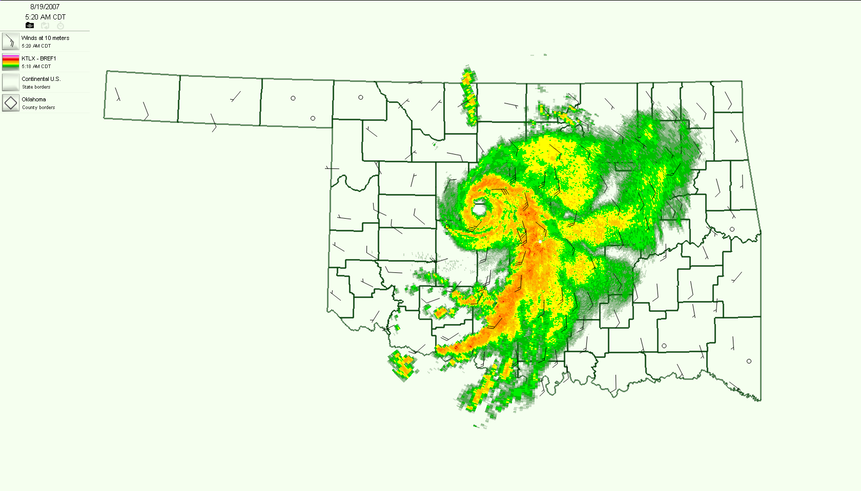
Okay, let me ask again, what would THAT mean for Oklahoma? In our past, it's
meant rainfall, and plenty of it. And we don't have to go back far to remember
the remnants of Tropical Storm Erin that strengthened back to TS strength over
the state and brought us a heap of trouble during August 2007.


A few other notable encounters with Oklahoma Gulf storms include:

* Dean, August 1995: 12-16 inches in parts of OK; interacted with weak,
stalled cold front; major flooding along much of Salt
Fork of the Arkansas River in Grant and Kay Counties;
flooding also occurred on Cimarron, Washita and
Arkansas Rivers.

* Gilbert, September 1988: Interaction with slow-moving front; 4+ inch
rains fell onto saturated soils; flooding on
creeks and rivers.


* Carla, September 1961: Up to 9 inches of rain fell across central and
north central Oklahoma.

* Unnamed, September 1900: The remnants of the hurricane that devastated
Galveston inundated eastern Indian Territory
with flooding rainfall.

So there you have it. An active Atlantic hurricane season CAN have an impact on
Oklahoma, but it's not a guarantee it will. In fact, Oklahoma is probably more
impacted by the Pacific hurricane season, and that side of the continent is
expected to have a less-active season.

Gary McManus
Associate State Climatologist
Oklahoma Climatological Survey
(405) 325-2253
gmcmanus@mesonet.org
May 28 in Mesonet History
| Record | Value | Station | Year |
|---|---|---|---|
| Maximum Temperature | 105°F | BEAV | 2022 |
| Minimum Temperature | 39°F | KENT | 2016 |
| Maximum Rainfall | 4.53 inches | MANG | 2023 |
Mesonet records begin in 1994.
Search by Date
If you're a bit off, don't worry, because just like horseshoes, “almost” counts on the Ticker website!