Ticker for January 30, 2009
MESONET TICKER ... MESONET TICKER ... MESONET TICKER ... MESONET TICKER ...
January 30, 2009 January 30, 2009 January 30, 2009 January 30, 2009
An Anatomic Comic of Winter Precip
We had several inquiries about how and why winter precipitation takes
so many forms. Here's a quick overview of what it takes to make the
winter precip that we've grown to know and, uh, despise.
First of all, some big picture concepts:
1. Around here, nearly all winter precip starts off as snow. That may
be obvious to some, but it's worth stating.
2. The type of precip that we experience at the surface has SO MUCH
to do with the vertical temperature profile of the atmosphere (or,
as you go up and down in the atmosphere, what are the temps like?)
3. Snow melts very readily in above-freezing temperatures, because
it is a delicate crystalline structure with lots of surface area.
4. Liquid water doesn't freeze as fast as snow melts. A good analogy
to think about is this. Remember ice cube trays? When you fill
up with water and stick them in the freezer, they don't freeze
instantly. It takes some time being exposed to sub-freezing
conditions to freeze. Water droplets don't take as long, but the
process is definitely not instant.
Okay with those on record, here's an example of the different precip
types, and the temperature profiles that support them.
Snow.
This one is probably the "simplest" conceptually. Here's a picture
of a profile that supports snow:
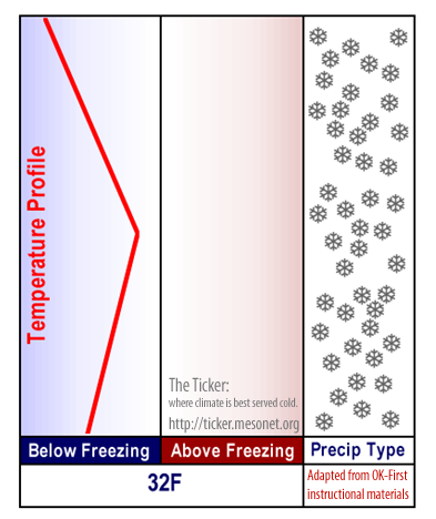
Notice that the atmospheric temperature (red line) is on the cold
side of 32F throughout the depth of the profile. So, the snowflakes
survive the entire trip down, and touch our noses as snowflakes.
Freezing Rain.
Okay, here's where it starts to get flaky ("flaky" ... get it?).
Anyway, things start getting weird when you introduce a layer of
above-freezing temperatures (a "warm layer") somewhere in the
atmosphere. Snow melts rapidly in a warm layer (see concept #3
above). This changes the snow to droplets in the warm layer:
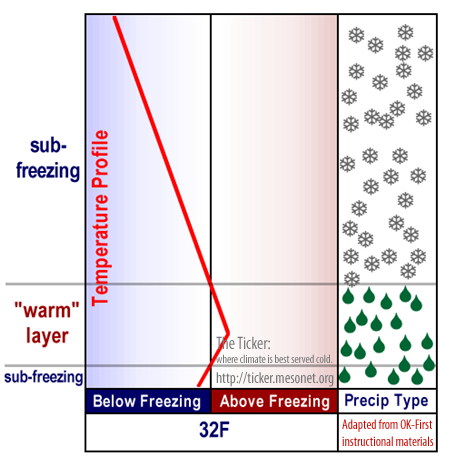
The key for freezing rain is that there is a very shallow layer
of cold air near the surface. In a freezing rain situation, this
cold surface layer is TOO shallow for re-freezing in the air.
In other words, the little droplets don't have the room/time
to re-freeze, even though the temperatures are below freezing
(see concept #4 above).
Instead of freezing in the air, they will freeze shortly after
striking sub-freezing objects attached to the earth. These could
be power lines, roads, grass, tree limbs, whatever. And this is
bad news.
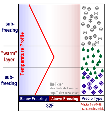
Sleet.
If the surface "cold layer" is deep enough (and cold enough), the
little droplets WILL re-freeze in the air as they fall, and hit
the surface as ice pellets, or sleet:
Rain.
Don't forget rain: our most common form of winter precipitation.
If surface temperatures are above freezing, we'll get rain. Or,
at worst, "Melting snow":

So, for winter storms, it's the depth and location of this "warm
layer" (if there is one) that makes the difference in the
precipitation type we get. And this is why we almost always see
a progression from rain to freezing rain to sleet to snow as we
move from the "warm side" of a precip shield to the cold side.
That's exactly what we saw earlier this week, on a line from
Louisiana through Kansas.
A few other notes regarding winter precipitation:
A. There's rarely a definite line between one precip type and the
next. It's more of a transition from one type to another, with
substantial overlap.
B. Winter weather forecasting is TOUGH business. Not only do
forecasters have to get the freezing line exactly right on
a map, but they have to get it right in the vertical, too!
This, combined with "A", are the main reasons why winter
weather forecasts often change so much from day-to-day or
hour-to-hour, even from the most skilled and experienced
forecasters ... it's just such a delicate situation!
January 30 in Mesonet History
| Record | Value | Station | Year |
|---|---|---|---|
| Maximum Temperature | 85°F | HOLL | 2016 |
| Minimum Temperature | -3°F | HOOK | 2010 |
| Maximum Rainfall | 3.50 inches | VALL | 2025 |
Mesonet records begin in 1994.
Search by Date
If you're a bit off, don't worry, because just like horseshoes, “almost” counts on the Ticker website!