Ticker for January 29, 2009
MESONET TICKER ... MESONET TICKER ... MESONET TICKER ... MESONET TICKER ...
January 29, 2009 January 29, 2009 January 29, 2009 January 29, 2009
February Has Range
We have a piece of breaking news: February starts on Sunday (remember,
you heard it here first). Climatologically speaking, the second month
can do Soprano or Baritone. The statewide average temperature for
February has been as low as 26.6F (in 1899 and 1906) and as warm as
50.7 (1954). This "range" of 24.1 degrees is the largest on the
calendar, slightly wider than flexible January's 22.9, and laughing
at July's quite rigid 12.2 degrees.
You can see February's erratic behavior represented by the black
diamonds on this trace of all Februaries since 1895:

Ice: On Slowly, Off Quickly
Here's a cool meteogram sent in by Ticker reader Mark Sessing:
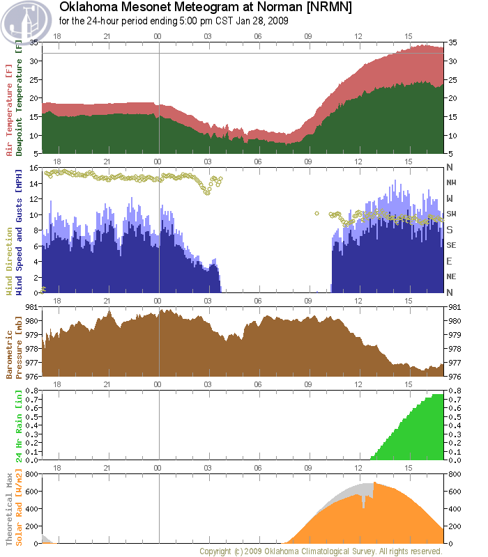
He pointed to an interesting feature in the observed solar radiation
(sunlight) at the Norman site. See how the curve jumps from one arc
to another at about 1pm yesterday? Very cool! What would cause the
sun to suddenly burn about 30% more brightly during the course of
the day?
Turns out, a lot of stuff happened midday yesterday. The wind sensor
(blue traces) sprung to life shortly before noon. The rain gauge
started recording precipitation (increasing green trace). And, not
coincidentally, the temperature warmed to above-freezing.
So, yes, this is exactly what you think: ice melting. It freed the
wind sensor, melted the ice in the rain gauge, and caused that
peculiar trace on the sunlight sensor.
Here's how.
The sky was clear all day. Therefore, the sun trace took a similar
curve to the theoretical "clear sky" trace (gray), except much
reduced. This is clear (well, partially clear) evidence of ice on
the sensor. By partially clear, we mean that ice has some "optical
thickness" (not unlike your Ticker author). Optical thickness means
that a substance filters or obstructs sunlight.
How does ice do this? Well, ice is filled with trapped air and
impurities (not unlike your Ticker author). These reduce the amount
of light that reaches the sensor.
When the ice melted, the sun trace jumped right back to the gray
"clear sky" trace.
January 29 in Mesonet History
| Record | Value | Station | Year |
|---|---|---|---|
| Maximum Temperature | 81°F | MANG | 2016 |
| Minimum Temperature | 2°F | BUFF | 2014 |
| Maximum Rainfall | 3.19 inches | BREC | 1999 |
Mesonet records begin in 1994.
Search by Date
If you're a bit off, don't worry, because just like horseshoes, “almost” counts on the Ticker website!