Ticker for January 28, 2009
MESONET TICKER ... MESONET TICKER ... MESONET TICKER ... MESONET TICKER ...
January 28, 2009 January 28, 2009 January 28, 2009 January 28, 2009
We Prefer the Term "Hydrologically Consistent"
While the precipitation has stopped falling from the skies, the
Oklahoma Mesonet isn't finished observing it. Here's a map of
precipitation accumulation over the past twelve hours (as of 2:30p):
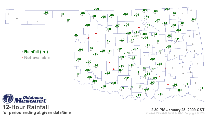
Now, here's the thing: that precip didn't fall from the sky. It did,
however, fall through the rain gauges.
Huh?
The Oklahoma Mesonet is operated by solar power. While this makes for
a much friendlier ecological footprint (not to mention it allows
observation in rural areas where AC power is not realistic), it also
means that some power-budget decisions must be made. One of the
consequences is that Mesonet rain gauges are not heated; therefore,
frozen precipitation is not collected until it melts and drains through
the gauge.
So, today, when the Sun came out, so too did the apparent precip.
And, it also explains why no precip has yet to be observed in the
southeast and east-central parts of Oklahoma: we're still frozen up
over there!
Speaking of frozen up: the wind observations took a beating this week:

All of those non-observations of wind represent sensors that were
frozen up during the course of the ice event (and therefore rendered
useless to observe wind). The Mesonet QA Crew will do some clean-up
of their own in coming days, making sure to restore wind data that
came online as stations thawed out.
January 28 in Mesonet History
| Record | Value | Station | Year |
|---|---|---|---|
| Maximum Temperature | 83°F | MANG | 2015 |
| Minimum Temperature | -1°F | BUFF | 2009 |
| Maximum Rainfall | 2.87 inches | TIPT | 2010 |
Mesonet records begin in 1994.
Search by Date
If you're a bit off, don't worry, because just like horseshoes, “almost” counts on the Ticker website!