Ticker for June 6, 2008
MESONET TICKER ... MESONET TICKER ... MESONET TICKER ... MESONET TICKER ...
June 6, 2008       June 6, 2008       June 6, 2008       June 6, 2008


Extreme Straight-line Winds

Last night was very busy, in a weather sense. No less than 36 severe
wind observations were captured by the Mesonet, including a whopping
98 mph at Cherokee. There were surely many more between Mesonet
stations. A complete list follows today's edition of the Ticker.

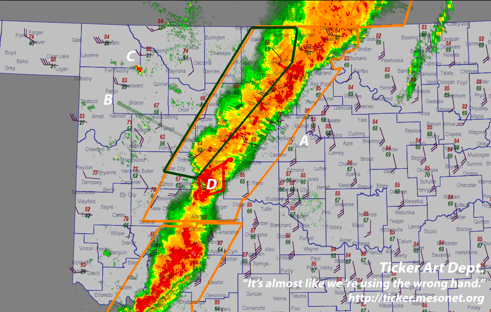
Take a look at a snapshot of last night's action:


It's so busy that you need a scorecard. Here's ours:

TICKER SCORECARD:

A. Position A in the image above highlights the *GIANT* warnings
issued by the National Weather Service Forecast office. Honestly,
when the Weather Radio in the Ticker Office read the counties
involved, it split it into chapters.

Why so big? Well, these storms were driven by an intense dynamic
environment (evidenced by the howling non-storm winds yesterday).
Because of this, these multi-cell part didn't really have
"a severe part" ... they were pretty much severe (58+ winds)
across the board. Hence, big warnings.

B. The Oklahoma City radar is sending out a peculiar spike in this
image. What is it? Just the setting sun, slightly north of the
horizon. This is a case where the radar can offer up the
Leftfielder's Ancient Lament: the sun really did get in its eyes.

C. See that peculiar blip in northern Woodward County? That was
actually observed by the Vance AFB radar (near Cherokee). Care
to guess what it's observing? Here's a hint:


(subtle, huh?)

Now, you might be saying to yourself "Wait a minute, didn't the
Ticker claim, just yesterday, that radar beams travel thousands
of feet above the ground as the move away from the radar site?"

If you are thinking that, first of all, we congratulate you for
the grammatical depth and punctuation in your internal thoughts.
You must be a real Wordsworth. Secondly, you're right, we did
claim that, and obviously, the radar is still picking up the
wind farm. Are they that tall? No. The radar beam was actually
bent (refracted) back toward the ground by a shallow layer
of slightly more dense air behind a "cold" front.

For details on how this happens, see the May 22, 2007 Ticker:
http://ticker.mesonet.org/select.php?mo=05&da=22&yr=2007

D. Finally, notice the traffic jam of warnings for Blaine County.
At the same time, parts of the county are under tornado, severe
thunderstorm, and flash-flood warnings. They are all justifiable
warnings. However, consider how we have become accustomed to
relying on information from the (excellent) television
meteorologists in the area.

And in situations like this, how should they convey the threat
visually? Tornadoes reign supreme here, so most likely, the
entirety of Blaine County was painted red, indicating tornado
threat. But if you were in Watonga or Okeene, are you really
threatened by a tornado?

We bring this up because there have been past cases in which
Oklahomans were found in their basement drowned - they had
presumably been taking shelter from a tornado warning elsewhere
in their county.

It's a serious and challenging issue, and one for which we
have no immediate answers. But, hopefully, this case gets
people thinking and talking about how to differentiate threats
in cases like these.


Yesterday's Severe Winds
Authored by Mother Nature, Recorded by the Mesonet
Cherokee     98 mph       5:10 pm
Watonga      75 mph       7:05 pm
Butler       75 mph       5:05 pm
Pryor        71 mph      12:45 am
Bessie       71 mph       7:35 pm
Medford      69 mph       6:50 pm
Medford      67 mph       6:45 pm
Minco        66 mph       9:20 pm
Fairview     66 mph       5:45 pm
Goodwell     65 mph       5:10 pm
Goodwell     65 mph       5:05 pm
Grandfield   64 mph       9:40 pm
Fairview     64 mph       6:20 pm
Beaver       63 mph       7:25 pm
Bixby        62 mph      12:00 am
Putnam       62 mph       5:10 pm
Bessie       61 mph       7:30 pm
Minco        61 mph       7:15 pm
Fairview     61 mph       6:00 pm
Goodwell     61 mph       5:50 pm
Fairview     60 mph       5:50 pm
Butler       60 mph       5:10 pm
OKC North    59 mph       9:55 pm
Grandfield   59 mph       9:25 pm
Weatherford  59 mph       8:20 pm
Minco        59 mph       7:10 pm
Beaver       59 mph       6:10 pm
Goodwell     59 mph       5:15 pm
Minco        58 mph       9:25 pm
Chickasha    58 mph       9:15 pm
Retrop       58 mph       7:10 pm
Watonga      58 mph       7:00 pm
Minco        58 mph       6:55 pm
Butler       58 mph       6:50 pm
Beaver       58 mph       6:25 pm
Medford      58 mph       6:15 pm
Medford      58 mph       5:55 pm
Hinton       58 mph       5:40 pm
June 6 in Mesonet History
| Record | Value | Station | Year |
|---|---|---|---|
| Maximum Temperature | 104°F | CHER | 2011 |
| Minimum Temperature | 38°F | BOIS | 1998 |
| Maximum Rainfall | 4.75″ | TULN | 2019 |
Mesonet records begin in 1994.
Search by Date
If you're a bit off, don't worry, because just like horseshoes, “almost” counts on the Ticker website!