Ticker for March 30, 2006
MESONET TICKER ... MESONET TICKER ... MESONET TICKER ... MESONET TICKER ...
March 30, 2006 March 30, 2006 March 30, 2006 March 30, 2006
A Picture is Worth a Few Dozen Processes
One radar/Mesonet image from 2:36 this afternoon can convey a number
of different, yet related, happenings in today's chraged environment:

The "D" marks the radar signature of the dryline (also evident in
the Mesonet wind data). Surface boundaries can show up on radar
because of subtle differences in the density of the air masses on
either side (the dust, bugs, and whatnot scooped up by their
convergence doesn't hurt, either).
Several storms that fired along that boundary are prominent. Some
of them became supercells, including the impressive storm marked by
the "S".
A smoke plume from a fire in the dry air northwest of Woodward is
marked by "F". Notice its parallel orientation with the westerly
surface winds.
One of a series of windshift/convergence lines that collectively
constitute a cold frontal zone is marked by "C".
And, the intersection of that convergence line with the dry line
is marked by "T", for "triple point". And triple points are important
on days like today because they often provide the added lift to
ignite convections.
And, take a look at the map an hour later:
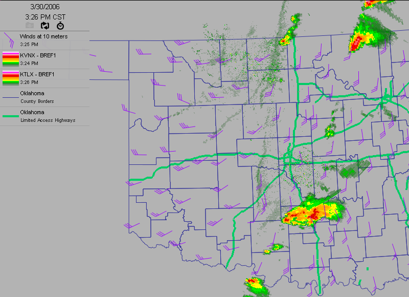
A cell was indeed spawned in the neighborhood of the triple point!
(For extra credit: check out the multiple lines of covergence to
the triple point's west and southwest!).
March 30 in Mesonet History
| Record | Value | Station | Year |
|---|---|---|---|
| Maximum Temperature | 92°F | ARNE | 2010 |
| Minimum Temperature | 20°F | ANTL | 2003 |
| Maximum Rainfall | 5.20 inches | IDAB | 2002 |
Mesonet records begin in 1994.
Search by Date
If you're a bit off, don't worry, because just like horseshoes, “almost” counts on the Ticker website!