Ticker for March 20, 2006
TICKER CORRECTION .... TICKER CORRECTION ...
March 20, 2006 March 20, 2006 March 20, 2006 March 20, 2006
Whoops, we discovered a little bug in our calculations ... which meant
that we over estimated this weekend's rainfall in southern Oklahoma.
The images are fixed, and we've made corrections in the text below.
We'll Walk Down The Lane with a Happy Refrain
If this weekend's weather makes you want to swing from a lamppost
and kiss Debbie Reynolds ... well, get in line, buddy.
Mother Nature is still tweaking her weekend totals, but here's a
breakdown as of noon today (in a refreshing, minty green!):

Of course, we've been mired in drought for months ... and this ain't
the end, but let's hope it's the beginning of the end.
To illustrate how dry it's been, the following two maps show the
number of days going back from Friday it would take to match the
weekend rains. The first map shows the number of days, while the
second shows the date that number represents.
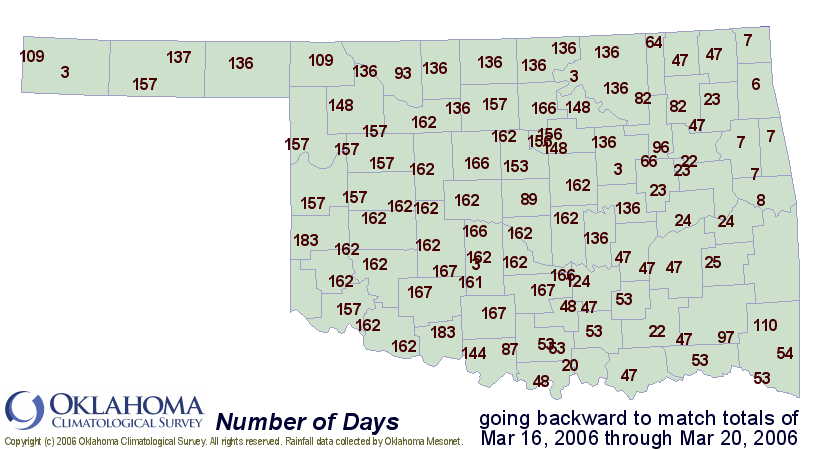
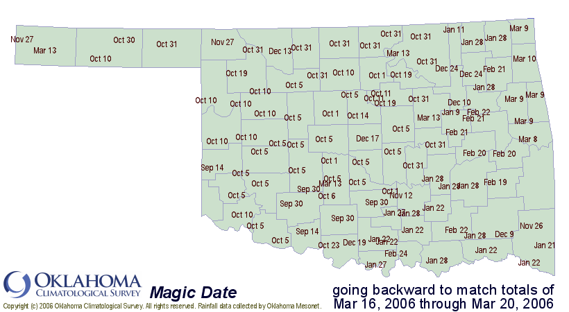
In other words, at the Erick Mesonet site, to match the 1.71" that
has fallen over the weekend, one would have to accumulate all the
rains dating back to September 14th, a span of 184 days!
Use the maps with caution, though ... the 110 days to match Kenton's
weekend total might imply a deluge, when in fact they received a
quarter-inch. It's just been *that* dry in the panhandle.
March 20 in Mesonet History
| Record | Value | Station | Year |
|---|---|---|---|
| Maximum Temperature | 98°F | BUTL | 2017 |
| Minimum Temperature | 8°F | KENT | 2016 |
| Maximum Rainfall | 5.14 inches | FORA | 2007 |
Mesonet records begin in 1994.
Search by Date
If you're a bit off, don't worry, because just like horseshoes, “almost” counts on the Ticker website!