Ticker for June 28, 2005
MESONET TICKER ... MESONET TICKER ... MESONET TICKER ... MESONET TICKER ...
June 28, 2005      June 28, 2005      June 28, 2005      June 28, 2005


Good To Be Home

The Entire Ticker Staff just returned from a weeklong climatology
meeting in Savannah, Georgia. It sure was hot and muggy in the
Deep South. After a week of heat and humidity, stepping off the
plane into an Oklahoma June afternoon was ... uh, never mind.


Seasonal Artifact Appears in Fire Danger Maps

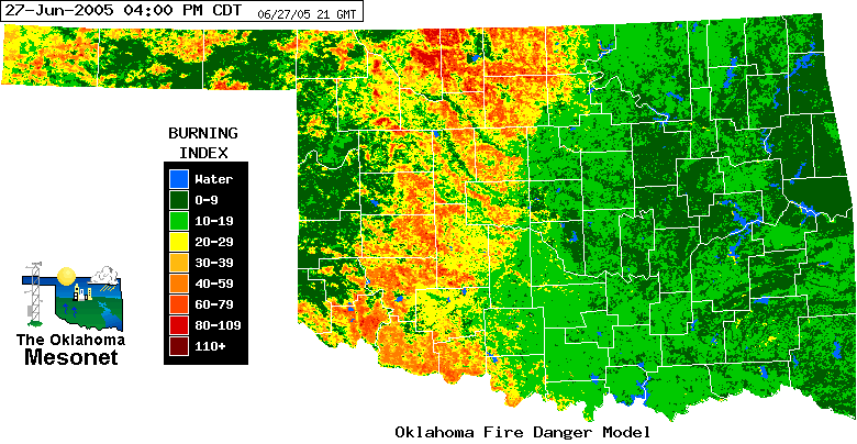
The Burning Index map from yesterday's Oklahoma Fire Danger Model
shows an interesting, and very bright signature from Medford to Altus:


Hmmm ... that line of enhanced fire danger (according to the model,
anyway) looks real familiar. Well, one of the main ingredients of the
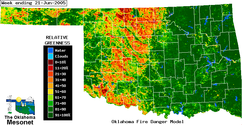
Oklahoma Fire Danger model is vegetation greenness, measured weekly
by satellite. Here is this week's satellite input:


It seems there is a distinct band of non-greenness in that same swath!

Of course, this is Oklahoma's famous winter wheat belt, which was
recently harvested, leaving our decidedly non-green soil naked to the
satellite's eye. The quirky signature made its way into the fire
danger model.

By the way, the exact opposite occurs in winter and early spring, when
the vibrantly green wheat belt is bordered by browner pastures.
June 28 in Mesonet History
| Record | Value | Station | Year |
|---|---|---|---|
| Maximum Temperature | 113°F | ALTU | 2023 |
| Minimum Temperature | 48°F | EVAX | 2022 |
| Maximum Rainfall | 3.95″ | WEST | 2000 |
Mesonet records begin in 1994.
Search by Date
If you're a bit off, don't worry, because just like horseshoes, “almost” counts on the Ticker website!