Ticker for June 17, 2005
MESONET TICKER ... MESONET TICKER ... MESONET TICKER ... MESONET TICKER ...
June 17, 2005      June 17, 2005      June 17, 2005      June 17, 2005


Washington Grabs the Pennant

All professions have their elusive, fabled, singular achievements
that represent the charmed assembly of performance, timing and
fate. Pitchers strive for the perfect game, batters can hit for the
cycle, climatologists try to find a cup of coffee with a lid that
doesn't dribble.

Well, for surface stations, the wind pennant is their perfect game.
The pennant is a little flag that indicates a 50+ mph sustained wind
(not a gust, but a five-minute average). It usually stays on the
shelf, an attractive but unused tool (not unlike china from your
wedding, or that treadmill you got a few years back).

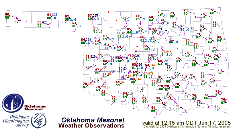
Well, the Washington Mesonet station got to show off its wind pennant
at 12:15 this morning.  Moreover, with a sustained wind of 55 mph,
it added a little-bitty 5-mph wind barb:


How rare is the wind pennant?  The 12:15 am reading was Washington's
1,205,344th wind observation of its 11-year career, and its second
wind pennant.


Storm Wrap-Up

Last night's and this morning's convection featured widespread
strong straight-line winds.  Here are the event's wind gusts that
exceeded the 58 mph severe-wind threshold:

Mesonet Stn    Gust       Date & Time
Washington     79 mph     Jun 17 12:15 am
Tishomingo     75 mph     Jun 17  2:00 am
Marshall       75 mph     Jun 16 10:30 pm
Minco          70 mph     Jun 16 11:30 pm
Chickasha      68 mph     Jun 16 11:50 pm
Tishomingo     66 mph     Jun 17  2:05 am
Acme           66 mph     Jun 17 12:10 am
Slapout        65 mph     Jun 16  8:40 pm
Ninnekah       64 mph     Jun 16 11:55 pm
Camargo        64 mph     Jun 16  9:55 pm
Freedom        64 mph     Jun 16  8:20 pm
Ringling       63 mph     Jun 17  1:20 am
Walters        63 mph     Jun 17 12:50 am
Lahoma         63 mph     Jun 16  9:45 pm
Acme           62 mph     Jun 17 12:05 am
Hollis         61 mph     Jun 17 12:15 am
Weatherford    61 mph     Jun 16 11:15 pm
Marena         61 mph     Jun 16 11:05 pm
Alva           61 mph     Jun 16  8:35 pm
Washington     60 mph     Jun 17 12:20 am
Washington     60 mph     Jun 17 12:10 am
Ninnekah       60 mph     Jun 17 12:05 am
Camargo        60 mph     Jun 16  9:50 pm
Lahoma         60 mph     Jun 16  9:40 pm
Washington     59 mph     Jun 17 12:25 am
Weatherford    59 mph     Jun 16 11:00 pm
Putnam         59 mph     Jun 16 10:15 pm
Seiling        59 mph     Jun 16  9:55 pm
Hobart         58 mph     Jun 16 11:40 pm
Perkins        58 mph     Jun 16 11:20 pm
Bessie         58 mph     Jun 16 10:55 pm
Slapout        58 mph     Jun 16  8:45 pm


Nowhere to Go But Up

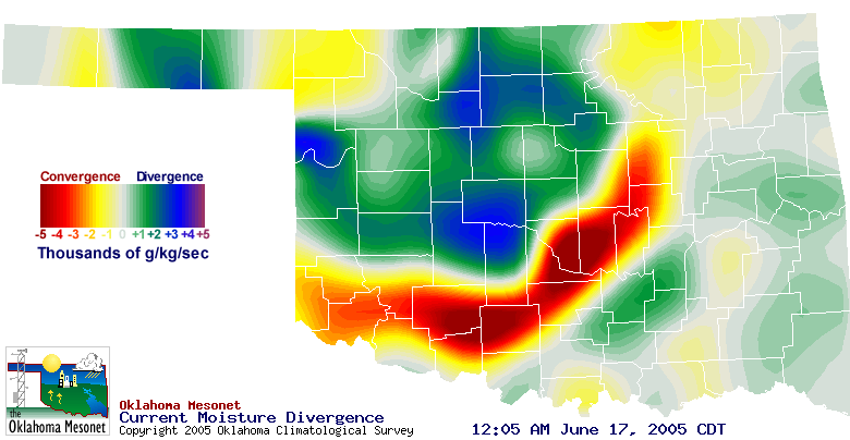
The generally northerly winds rushing from the storms met generally
southerly winds to produce very strong convergence:


This map shows where air and its many passengers (water vapor molecules)
are coming together (convergence) and where they are spreading apart
(divergence). The red belt shows high levels of this "moisture
convergence". When convergence is strong, air has nowhere to go but up!
Convergence and moisture convergence is an essential ingredient of
storm development and propagation.
June 17 in Mesonet History
| Record | Value | Station | Year |
|---|---|---|---|
| Maximum Temperature | 114°F | GRA2 | 2011 |
| Minimum Temperature | 45°F | BEAV | 1999 |
| Maximum Rainfall | 10.49″ | NEWP | 2015 |
Mesonet records begin in 1994.
Search by Date
If you're a bit off, don't worry, because just like horseshoes, “almost” counts on the Ticker website!