Ticker for March 28, 2003
MESONET TICKER ... MESONET TICKER ... MESONET TICKER ... MESONET TICKER ...
March 28, 2003     March 28, 2003     March 28, 2003     March 28, 2003


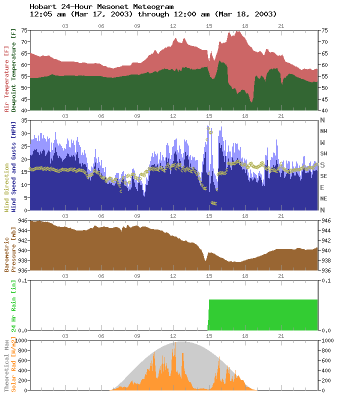
Meteogram Reflects Close Passage of Tornadic Supercell

Early last week, a tornadic supercell passed within a few miles
of the Mesonet site at Hobart.  The meteogram from that site gives
clear evidence of the mesoscale impact of a supercell:


The build-up to the storm's mid-afternoon passage is very interesting.
Shortly after 1:00 pm, solar radiation values indicated a significant
obstacle to the sun.  At about 2:00 pm, winds at HOBA stiffened, and
began to back from southerly to easterly.  Surface pressure decreased
rapidly at this time.

As the storm's core passed to the west and north of the site, its
outflow appeared as northerly and northwesterly flow of significantly
cooler air, with a coincident pressure spike.

Ticker thanks to Jeff Basara, who spotted this meteogram last week.
March 28 in Mesonet History
| Record | Value | Station | Year |
|---|---|---|---|
| Maximum Temperature | 90°F | TIPT | 2022 |
| Minimum Temperature | 11°F | BOIS | 2009 |
| Maximum Rainfall | 4.20″ | ACME | 2017 |
Mesonet records begin in 1994.
Search by Date
If you're a bit off, don't worry, because just like horseshoes, “almost” counts on the Ticker website!