Ticker for March 7, 2003
MESONET TICKER ... MESONET TICKER ... MESONET TICKER ... MESONET TICKER ...
March 7, 2003      March 7, 2003      March 7, 2003      March 7, 2003


Whopper Cold Front: Part 3

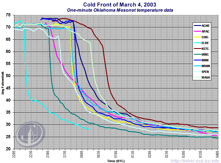
One last interesting image from this week's strong cold front.

The rough-and-ready Mesonet operators stayed late Tuesday night
to collect one-minute Mesonet data from several stations in central
and south-central Oklahoma.  We've compiled much of that data
as a series of temperature traces:


Several features jump out:

1. That was a strong cold front!  Some stations dropped 30 degrees
in 10 minutes.

2. The northwest-to-southeast progress of the front is apparent
in the time lag of these affected stations: El Reno was first,
then Minco, etc.

3. The rounded traces at Washington and Spencer show that these
station were just entering their sunset-time cooling when the
front hit.

Thanks to the Mesonet operators for rounding up one-minute data
during this interesting event!
March 7 in Mesonet History
| Record | Value | Station | Year |
|---|---|---|---|
| Maximum Temperature | 87°F | HOLL | 2006 |
| Minimum Temperature | 8°F | SEIL | 2008 |
| Maximum Rainfall | 3.76″ | PRYO | 1998 |
Mesonet records begin in 1994.
Search by Date
If you're a bit off, don't worry, because just like horseshoes, “almost” counts on the Ticker website!