Ticker for January 10, 2003
MESONET TICKER ... MESONET TICKER ... MESONET TICKER ... MESONET TICKER ...
January 10, 2003   January 10, 2003   January 10, 2003   January 10, 2003


Next Week: Wind Rose Appreciation Week

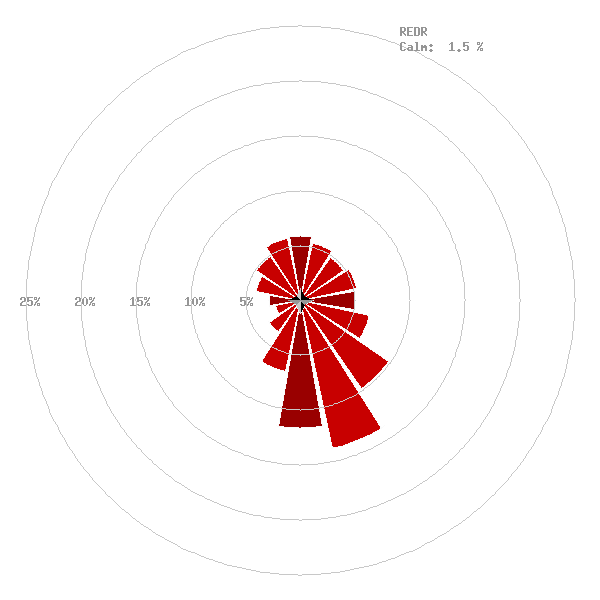
Wind roses are a useful climatological tool for understanding the wind
regime at a given location.  Each "petal" on the rose indicates the
frequency that the wind blows from that direction.  For example, this
wind rose describes the regime at the Red Rock Mesonet station:


It indicates that at Red Rock, south-to-southeasterly winds prevail.
This pattern is true for most of Oklahoma.  The data for this rose
came from eight years (1994-2001) of round-the-clock Oklahoma Mesonet
data.  At 288 observations per day, it's a sample of a little more
than 800,000 different wind reports.

That's great, but when we start slicing up data by region, or time
of day, or month, or temperature, or whatever, we can discover some
really interesting happenings with a wind rose.  Throw in wind speed
and the applications of the wind rose are almost limitless.

Over the holidays, we put together five interesting wind rose topics.
So, next week is Wind Rose Appreciation Week around here.  Stick around
for some (forgive me) rose-colored classes.
January 10 in Mesonet History
| Record | Value | Station | Year |
|---|---|---|---|
| Maximum Temperature | 84°F | BURN | 2023 |
| Minimum Temperature | -6°F | VINI | 2010 |
| Maximum Rainfall | 4.31″ | MADI | 2020 |
Mesonet records begin in 1994.
Search by Date
If you're a bit off, don't worry, because just like horseshoes, “almost” counts on the Ticker website!