Ticker for February 16, 2001
MESONET TICKER ... MESONET TICKER ... MESONET TICKER ... MESONET TICKER ...
February 16, 2001 February 16, 2001 February 16, 2001 February 16, 2001
Oklahoma's Ice Belt Wreaks Havoc on Wind Observations
Light freezing precipitation over the last few days left a belt of
ice-encrusted conditions over (roughly) Oklahoma's I-44 corridor
during the past few days.
The ice accumulated on pretty much any exposed, non-heated surface -
a group that includes Mesonet stations. Here are some images from
the Norman Mesonet station:
10m wind monitor:
1.5m air temperature and relative humidity:

Unless it's totally encased in ice, the T&RH sensor is not affected
significantly. However, the wind instruments rely on moving parts
to observe conditions, so they can get bogged down by the ice. And
that's exactly what happened at several stations.
Here's a meteogram from Burneyville, where ice accumulation was not
a problem:
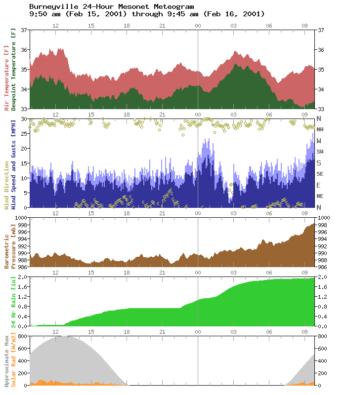
Notice that the wind speeds are generally 5-10 mph, with gusts of
10-15 or more.
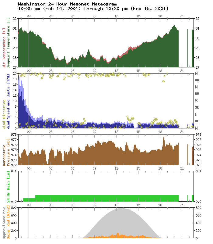
When looking at stations in this week's "ice belt", you can see that
ice accumulations caused observation of wimpy winds at Washington:
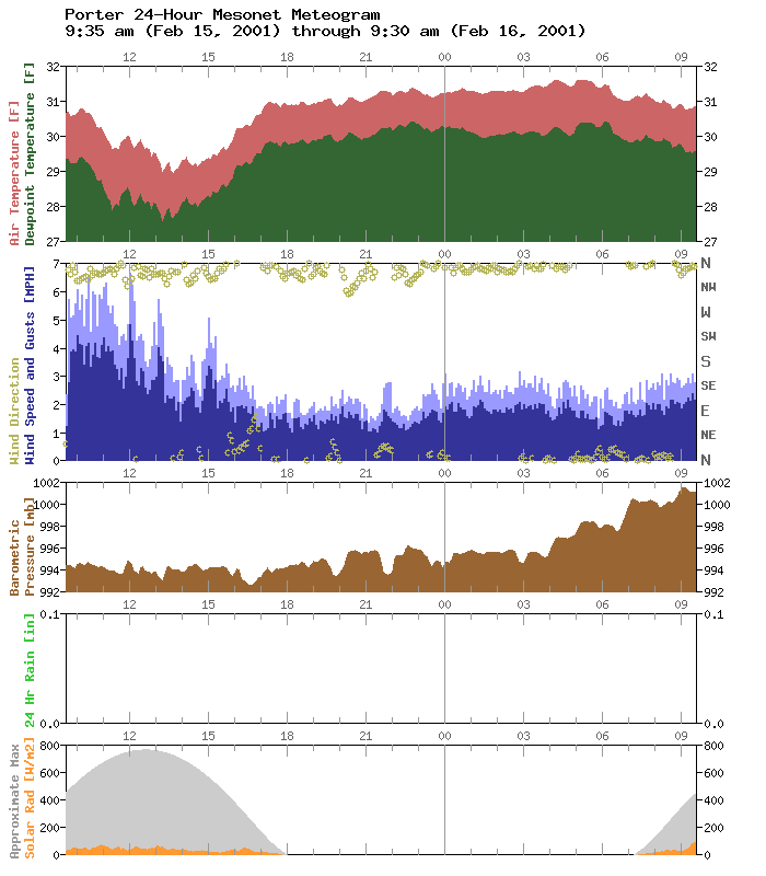
and puny puffs at Porter:
and Ninnekah (we'll stop the alliterative fun-poking here):
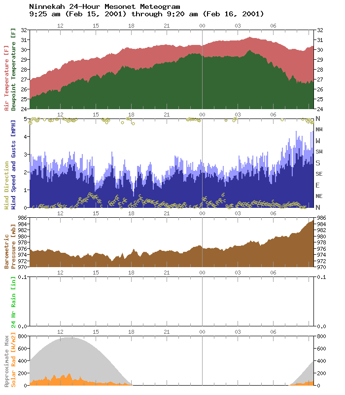
The Mesonet QA Manager will have his hands full next week when he
looks back through the archive and determines which wind observations
are true and which need to be flagged as affected by the ice.
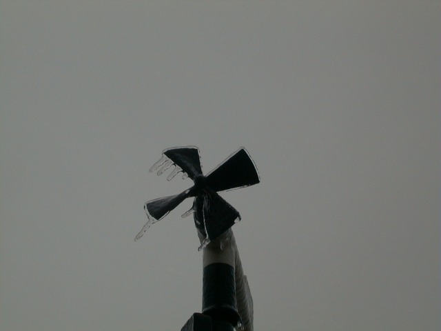
The Best Icicle Picture You'll See for a While
In addition to the meteorological standard 10-meter wind observation,
almost all Mesonet stations observe wind speeds at two meters. This
provides a canopy-height wind for agricultural and other applications.
Here's an image that the Mesonet Project Manager took of the Norman
station's 2-meter wind anemometer:
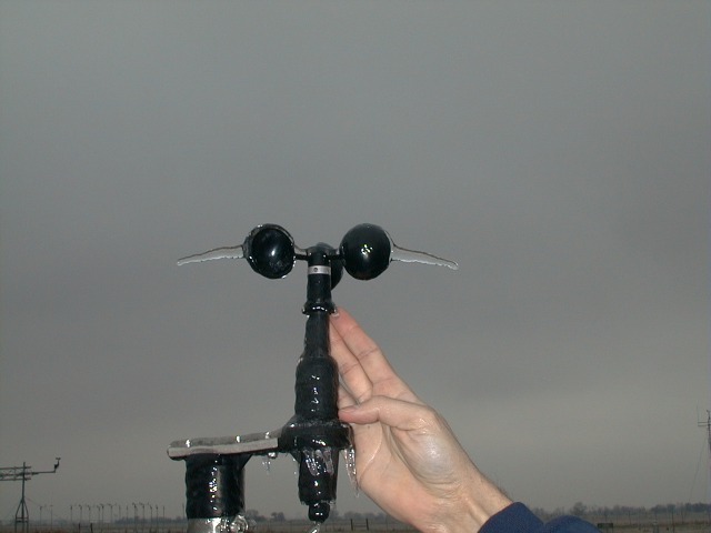
Look at those ice spikes sticking out horizontally! What are those?
Well, they are just like the icicles that form on your house, if your
house were to spin around at several revolutions per second.
In this case, cold water droplets on the spinning anemometer were
subject to centrifugal accelerations that dominated gravity. So,
instead of dripping downward before freezing, they "dripped" outward
before freezing.
So be careful the next time you're walking near a 2-meter anemometer
in freezing conditions. You tall folks could get whacked on the head
with an icicle!
February 16 in Mesonet History
| Record | Value | Station | Year |
|---|---|---|---|
| Maximum Temperature | 85°F | HOLL | 2011 |
| Minimum Temperature | -22°F | NOWA | 2021 |
| Maximum Rainfall | 3.37 inches | TALI | 2008 |
Mesonet records begin in 1994.
Search by Date
If you're a bit off, don't worry, because just like horseshoes, “almost” counts on the Ticker website!