Ticker for December 7, 1999
MESONET TICKER ... MESONET TICKER ... MESONET TICKER ... MESONET TICKER ...
December 7, 1999 December 7, 1999 December 7, 1999 December 7, 1999
What a Difference a Few Meters Makes
Yesterday morning provided an example of how terrain can strongly
influence local weather. Here is the map of weather conditions at
5:45 am Monday morning:
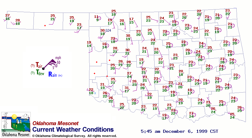
In northwestern Oklahoma, the Buffalo and Camargo Mesonet stations
were observing air temperatures of 11 F and 16 F, respectively.
Woodward, located in between these two stations, was reporting 30 F!
This discrepancy was a terrain-related feature. The Buffalo and
Camargo stations are located 559 and 587 meters above sea level,
respectively. Woodward sits at 625 meters. This means Woodward is
at a relative maximum in elevation on the Buffalo-Camargo transect.
That relative maximum was apparently enough to dictate that the
Woodward station was observing conditions above a very shallow
inversion layer, while Buffalo and Camargo were sampling the frigid
(for we Oklahomans, anyway) temperatures below.
The difference in wind speed is further evidence of this. Gusty winds
at the Woodward station, compared to calm observations at the other two
stations, suggest that it was poking out of an inversion layer that had
decoupled from the windy layer aloft during the overnight hours.
December 7 in Mesonet History
| Record | Value | Station | Year |
|---|---|---|---|
| Maximum Temperature | 80°F | BURN | 2007 |
| Minimum Temperature | -9°F | BOIS | 2005 |
| Maximum Rainfall | 1.27 inches | BBOW | 1997 |
Mesonet records begin in 1994.
Search by Date
If you're a bit off, don't worry, because just like horseshoes, “almost” counts on the Ticker website!