Ticker for December 6, 1999
MESONET TICKER ... MESONET TICKER ... MESONET TICKER ... MESONET TICKER ...
December 6, 1999 December 6, 1999 December 6, 1999 December 6, 1999
Old Man Winter Does a Number on Northwest Mesonet Stations
The Oklahoma Mesonet is a well-designed operation which archives well
over 99% of possible observations. However, last night provided a
couple of examples of how freezing precipitation can play with the
readings of an unmanned weather station. Yesterday's meteograms from
Boise City and Slapout show rainfall accumulation during a sunny
afternoon:
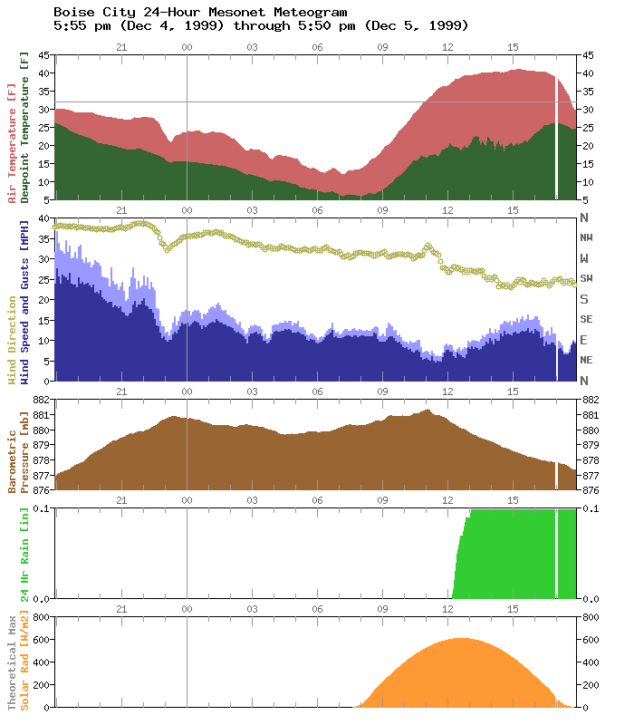
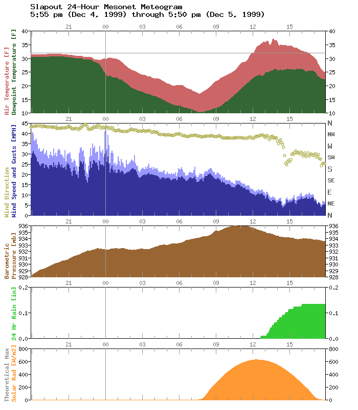
In fact, the bell-shaped solid orange curves in the solar radiation
panels indicate an entire day of cloud-free skies! How did this happen?
Is it real precipitation?
Yes, it is real, but the representation is a little bit late and in
a different form. The precipitation fell earlier as snow or ice and
accumulated in the catch basin of the rain gauge. As the icy morning
temperatures warmed to near freezing (and with the help of the
aforementioned sunny skies), the frozen stuff melted, dripped through
the funnel, and was recorded as rainfall.
An even rarer event occurred at the Buffalo station. Comparing its
pressure trace to nearby Slapout's, there's little agreement in the
trend during the morning hours.

Buffalo's pressure trace falls then rises dramatically, and this
certainly doesn't agree with Slapout's pressure trace. Slapout's
barometer was working fine. And the barometer at Buffalo was working
perfectly at the time. How?
Because that Buffalo pressure trace isn't really a recording of the
atmospheric pressure at Buffalo. And freezing precip is the culprit
here, too. In fact, this pressure trace is an almost certain indicator
of freezing rain at the station. How?
Mesonet barometers are housed in a plastic box with a little air port
on the bottom, to keep the pressure inside the box equalized to the
outside environment. As rainfall struck the housing it dripped to the
bottom and froze. When the port was frozen shut, the box became a
closed system with constant volume and (get out your old thermo book
here), according to Charles' Law, for finite amount of gas at a constant
volume, pressure is a function of temperature only.
That's why Buffalo's pressure trace is a faithful imitation of its
temperature trace between 3:00 am and 11:00 am. At about 11:00 am, just
like at the other stations, melting commenced. The ice jam broke, and
the barometer went back to measuring atmospheric pressure (the "leap"
back to reality can be seen at about exactly 11:00 am).
Those are a couple of examples of how freezing precip can throw a
wrinkle in your data. As the old oleo advertisement used to say:
"It's not nice for Mother Nature to fool the Mesonet."
Or something like that.
December 6 in Mesonet History
| Record | Value | Station | Year |
|---|---|---|---|
| Maximum Temperature | 77°F | ANTL | 2001 |
| Minimum Temperature | -6°F | KENT | 2011 |
| Maximum Rainfall | 1.31 inches | OKEM | 2004 |
Mesonet records begin in 1994.
Search by Date
If you're a bit off, don't worry, because just like horseshoes, “almost” counts on the Ticker website!