Ticker for June 11, 1999
MESONET TICKER ... MESONET TICKER ... MESONET TICKER ... MESONET TICKER ...
June 11, 1999      June 11, 1999      June 11, 1999      June 11, 1999


Western Oklahoma Shares the Wealth

A unique situation presents itself today.  As moderate to heavy
rainfall spreads over the western tier of counties, the runoff from
from this event will be routed all over the state.

Rainfall in most of Beckham County will be delivered to the Red by
its North Fork at a location near Altus.  Just a few miles north in
Roger Mills County, rain is partitioned between the Washita River
(destination: Lake Texoma) and the Canadian (Lake Eufaula by way of
Norman and Purcell).  Ellis County is primarily serviced by the
North Candian/Beaver River (Lake Eufaula by way of OKC and Shawnee).
The majority Harper County delivers into the Cimarron Basin.  This
water will visit Stillwater on its way to the Arkansas above Tulsa.

So, today's band of rain from Sayre to Buffalo (barely 100 miles apart)
will be delivered all over Oklahoma.


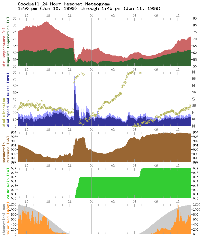
Goodwell Meteogram: There's a lot in there!

Last night, thunderstorms moved through the panhandle, with strong wind
gusts and heavy rains.  The Goodwell Mesonet station has observed quite
a bit of meteorology in the last 24 hours:


The temperature/dew point window shows a burst of rain-cooled air just
before 10:00 pm last night.

The winds window shows the wind gusts of 60, 74, and 59 mph which
delivered the rain-cooled air.  The wind direction behavior is also
very interesting.  The winds slowly turned clockwise around the entire
compass and more!

The pressure window shows the meso-high which accompanied the storm
system, as well as a slow decrease, then increase, in station pressure.
This might account for the slow rotation of the wind direction.

The rainfall window shows two distinct periods of heavy rain since
sunset last night.

Finally, the solar radiation window suggests intermittent cloudiness
yesterday afternoon, and mostly cloudy skies today.

This author is always surprised at the amount of meteorology that can
be packed into one Mesonet meteogram.
June 11 in Mesonet History
| Record | Value | Station | Year |
|---|---|---|---|
| Maximum Temperature | 108°F | ALTU | 2022 |
| Minimum Temperature | 44°F | KENT | 2004 |
| Maximum Rainfall | 6.05″ | COPA | 2007 |
Mesonet records begin in 1994.
Search by Date
If you're a bit off, don't worry, because just like horseshoes, “almost” counts on the Ticker website!