Ticker for June 16, 1999
MESONET TICKER ... MESONET TICKER ... MESONET TICKER ... MESONET TICKER ...
June 16, 1999 June 16, 1999 June 16, 1999 June 16, 1999
Rainall in Eastern Oklahoma
Heavy thundershowers have produced large local rainfall amounts in
northeastern Oklahoma today. According to Oklahoma Mesonet amounts,
the heaviest rains have fallen in a triangle from just south of the
Tulsa metropolitan area to near the Missouri border to near Ponca City.
Some selected 24-hour rainfall amounts from the Mesonet (updated every
15 minutes at  )
)
Blackwell 3.09"
Medford 2.20"
Hectorville 2.18"
Vinita 1.73"
Nowata 1.54"
Bixby 1.42"
Preston 1.35"
McAlester 1.24"
Jay 1.09"
Burbank 1.05"
Okmulgee .98"
Okemah .97"
Skiatook .89"
Foraker .89"
Haskell .86"
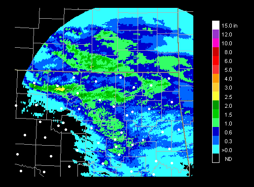
The amounts at Blackwell and Medford are supported by Weather Service
WSR-88D storm total amounts, which show a finger of larger precip events
at or very near the Mesonet stations (white dots) in Grant and Kay
Counties: 
June 16 in Mesonet History
| Record | Value | Station | Year |
|---|---|---|---|
| Maximum Temperature | 108°F | ALTU | 2011 |
| Minimum Temperature | 45°F | KENT | 1998 |
| Maximum Rainfall | 3.93″ | BLAC | 1997 |
Mesonet records begin in 1994.
Search by Date
If you're a bit off, don't worry, because just like horseshoes, “almost” counts on the Ticker website!